
The term ‘monitoring’ identifies the set of activities aiming at observing a phenomenon, or a variable which characterizes the phenomenon, to follow its regular development and/or to highlight the occurrence of critical or alarming conditions. Environmental monitoring, in particular, is directly linked to the management of natural resources which is carried out on the basis of information derived from the observation and/or data on the conditions of the Earth surface and of the atmosphere.
In this framework, data acquired by sensors onboard satellite platforms offer a unique opportunity of systematically observing natural vegetation, agro-ecosystems and water resources with a synoptic view and over large areas. Several satellite sensors are currently available for environmental monitoring, and the choice of the most suitable source of data in terms of revisiting time (frequency of observation) and geometric and radiometric resolutions depends on the type of application.
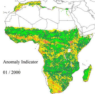
The use of time series of satellite data is of key importance for monitoring natural resources and the environment. The availability of long time series, which today can be as long as 30 years, allows the identification of geographic regions where present conditions are significantly different from the long time trends and thus need further and detailed analysis. In addition, near-real time (or quasi near-real time) satellite image acquisitions during a period of interest is crucial for a prompt intervention aimed at protecting the vegetation and/or limiting the damages as well as for the implementation of farming practices driven by the actual crop conditions.
In this framework, satellite images can be exploited to estimate parameters which are descriptors of the status of the environment; these parameters, together with in situ measurements and/or observations collected by traditional field campaigns and/or sensor networks, can be assimilated into mathematical models of the natural processes or used as source of information in operative monitoring systems.
For what concerns the land compartment, some of the parameters which can be estimated from satellite images are the biophysical properties of the vegetation (e.g. Biomass, Leaf Area Index – LAI, water content), the forest cover characteristics and status (forest cover classes, species composition, forest productivity, burned areas and fire occurrence), and the crops phenology and conditions (productivity and yield, phenological stages, water stress conditions, health status). For what concerns the water compartment of the ecosystems, some of the parameters which can be estimated from satellite images are related to the characteristics of the snow cover (e.g. snow cover extent, snow cover water equivalent) and the parameters which describe surface water quality as, for example, surfaxce temperature, transparency, chlorophyll concentration.