
Revealed, for the first time in Italy, in the Pollino area, the presence of slow fault movements during a sequence of low magnitude earthquakes, which help to explain why in this area, compared to the rest of the Apennines, the earthquakes of higher magnitude are less frequent. The study was published in "Scientific Reports".
During the long seismic sequence which affected the Pollino area (Italy) from 2010 to 2014, there were not only earthquakes but also a slow and continuous slip of faults, without any seismic activity. This has been pointed out the first time in Italy by a research just published in "Scientific Reports" by a team of researchers from the Institute of Geophysics and Volcanology (INGV), the Institute for Electromagnetic Sensing of the Environment of the National Research Council (IREA -CNR), in collaboration with the Civil Protection Department. The findings of the study shed new light on the seismicity in historical times in the Pollino area.
"In recent years," says Daniele Cheloni, Researcher at INGV and first author of the work, "it was noted that low magnitude seismic sequences are often accompanied by aseismic slip, although the lack of a sufficient number of ground deformation measurements during these sequences has prevented, so far, the proof of such hypothesis in the Italian area".
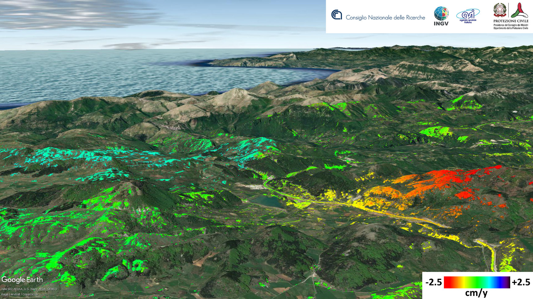
Earthquakes, as known, are caused by movements of faults, i.e., crustal fractures, which occur very quickly (within seconds). In other cases, the same faults may move slowly (over weeks or months) without generating earthquakes (aseismic slip). To demonstrate the simultaneous presence of seismic activity and aseismic movements, researchers have used the GPS station data (constellation of satellites of the Global Positioning System) of the INGV RING network (http://ring.gm.ingv.it), installed in 2011 as part of an INGV project for the study of the tectonic deformation in the Pollino area, and radar images collected from the COSMO-SkyMed satellite of the Italian Space Agency (ASI), provided as part of the ASI Open Call COSMO-SkyMed.
"Available Satellite data," explains Eugenio Sansosti Senior Researcher at IREA-CNR, "provided a high detail, both in space and in time, unimaginable with other sensors, allowing us to measure such subtle and slow ground deformations, like those related to aseismic slip". This was possible also thanks to the intensification of satellite acquisitions in the Pollino area set up by ASI, following a Civil Protection Department advice, during the seismic sequence.
The huge amount of satellite data available requires a precise and complex processing operation. "We used innovative techniques developed at our Institute over past years, to follow the changes over the time of the deformation signal," specifies Gianfranco Fornaro Senior Researcher at IREA-CNR, "and comparison of our results with GPS data did not leave room to any doubt on the reliability of our measurements."
The obtained results are important for the understanding of the seismicity in the Pollino area. Historical records of the last centuries show no evidence of large seismic events that, in fact, affect adjacent areas of the Apennines and Calabria. "The aseismic movement contributes to the release of a part of the tectonic deformation that would be released, otherwise, by earthquakes. This may explain why, compared to the rest of the Apennines, large magnitude earthquakes are relatively less frequent in the Pollino area. Further advances in the understanding of the seismogenic phenomena in the Italian area need observational systems like the RING GPS network, the COSMO-SkyMed mission, and the National Seismic Network," says Nicola D'Agostino, Senior Researcher at INGV and coordinator of the research.