FOREST FIRES IN EUROPE
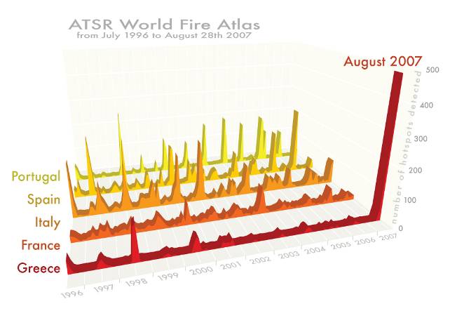
 In Europe, on average, about 65000 fires occur every year, burning approximately half a million hectares of vegetated areas; more than 85% of the area affected by fires is in Mediterranean countries (southern France, Greece, Italy, Portugal and Spain) (San-Miguel-Ayanz and Camia, 2010). Fires can become uncontrolled and cause large environmental and economic damages. Human activities are the main cause of forest fires and are responsible for over 97% of all European fires (Ganteaume et al., 2013). In southern Europe, 2003 and 2007 were the most dramatic fire seasons of the last years as shown by the fire records of the ESA ATSR World Fire Atlas. According to statistics provided by the EC-JRC European Forest Fires Information System (EFFIS), 700,117 ha and 862,452 ha of forest burned in 2007 and 2003, respectively.
Field surveys provide highly reliable information on the area affected by fires but for regional monitoring they become expensive and time consuming while remotely sensed techniques can provide consistent and continuous data. In the last decade, the decrease of imagery acquisition costs, the increase of images spatial resolution have pushed forward the use of EO (Earth Observation) technologies for wildfire monitoring. Although almost all of the available satellite sensors, both active and passive, have been exploited for fire monitoring (Corona et al., 2008), optical systems proved to be the most appropriate ones. In particular, Landsat TM/ETM+ (Thematic Mapper / Enhanced Thematic Mapper Plus) images have been widely used for regional burned area mapping in Europe. Moreover, the opening of the US-USGS (Glovis) and ESA archives has stimulated research for the development of automated methods for mapping burns (e.g. Mitri and Gitas, 2004; Bastarrika et al., 2011). Finally, the launch of the Operational Land Imager (OLI) and Thermal Infrared Sensor (TIRS) instruments onboard the Landsat 8 satellite (February 2013) will give continuity to the research effort and achievements.
In the framework of forest fires monitoring, IREA-CNR has carried out research on the use of satellite data acquired by both optical and radar sensors for mapping burned areas at regional scale (fuzzy algorithm for mapping burned areas).


