
The geophysical processes that take place in several kilometers below the earth's surface, such as the movement of a seismogenic fault, the accumulation of magma, the variation of pressure in the reservoirs magmatic, in many cases cause deformation of the earth's surface that can be measured with geodetic methods and remote sensing techniques such as SAR interferometry (InSAR). The results of these measurements and the subsequent geophysical modeling of the sources, due to the deformation, can provide crucial information for the assessment of volcanic and seismic risk and the proper planning of human activities.
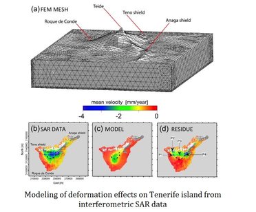
It is possible to model the deforming sources through analytical and numerical approaches. In analytical modeling, the most common models can reproduce the observed deformation in a sufficiently realistic way by using simple functions characterized by a limited number of parameters. Although in these simplified approaches are neglected several aspects (the properties of magma inside the source, including its compressibility, the asperities along the fault plane, the crustal heterogeneity), the analytical models are still a valuable tool for a preliminary evaluation on the localization and the geometric characteristics of the sources that have generated the observed deformation, information obtained through the inversion of surface deformation data (InSAR, GPS, EDM, tiltmetric, etc ...).
Numerical modeling is a powerful tool that can allow realistic simulations of geophysical processes, using heterogeneous information and efficient mathematical methods. There are various numerical modeling techniques; the most used in the Earth Sciences is the FEM (Finite Element Method) technique. The exponential increase in knowledge of geophysical systems and technological development of numerical modeling tools have enabled the implementation of more and more complex modeling approaches, able to represent the spatio-temporal variability of the physical parameters that influence the development of a natural system. In this context, the finite element modeling multi-physics is a new frontier for the understanding the spatial and temporal evolution of different geodynamic settings such as volcanic and seismic areas and those with a hydrogeological instability.
IREA is committed to the development of research activities on the geophysical modeling of remote sensing data; these activities have already provided important results in the study of the major earthquakes that have hit our country in recent years. Relevant are also the results of the analysis of the main Italian volcanoes and various other volcanic sites of great scientific interest.
