
 An international team of researchers from the Institute for Electromagnetic Sensing of the Environment (CNR-IREA) in Naples and the Instituto Volcanológico de Canarias (INVOLCAN) in Tenerife (Spain) recently published an innovative study on the largest historical eruption ever recorded in La Palma, one of the Canary Islands, which occurred on September 19, 2021. The Tajogaite eruption aroused interest not only for its immediate impacts, but also for the significant amount of information obtained useful for scientific purposes.
The study, published in the prestigious journal Scientific Report, examined in detail the previous eight days and the first ten days of the eruption, revealing unknown elements of the dynamics and evolution of the island's volcanism.
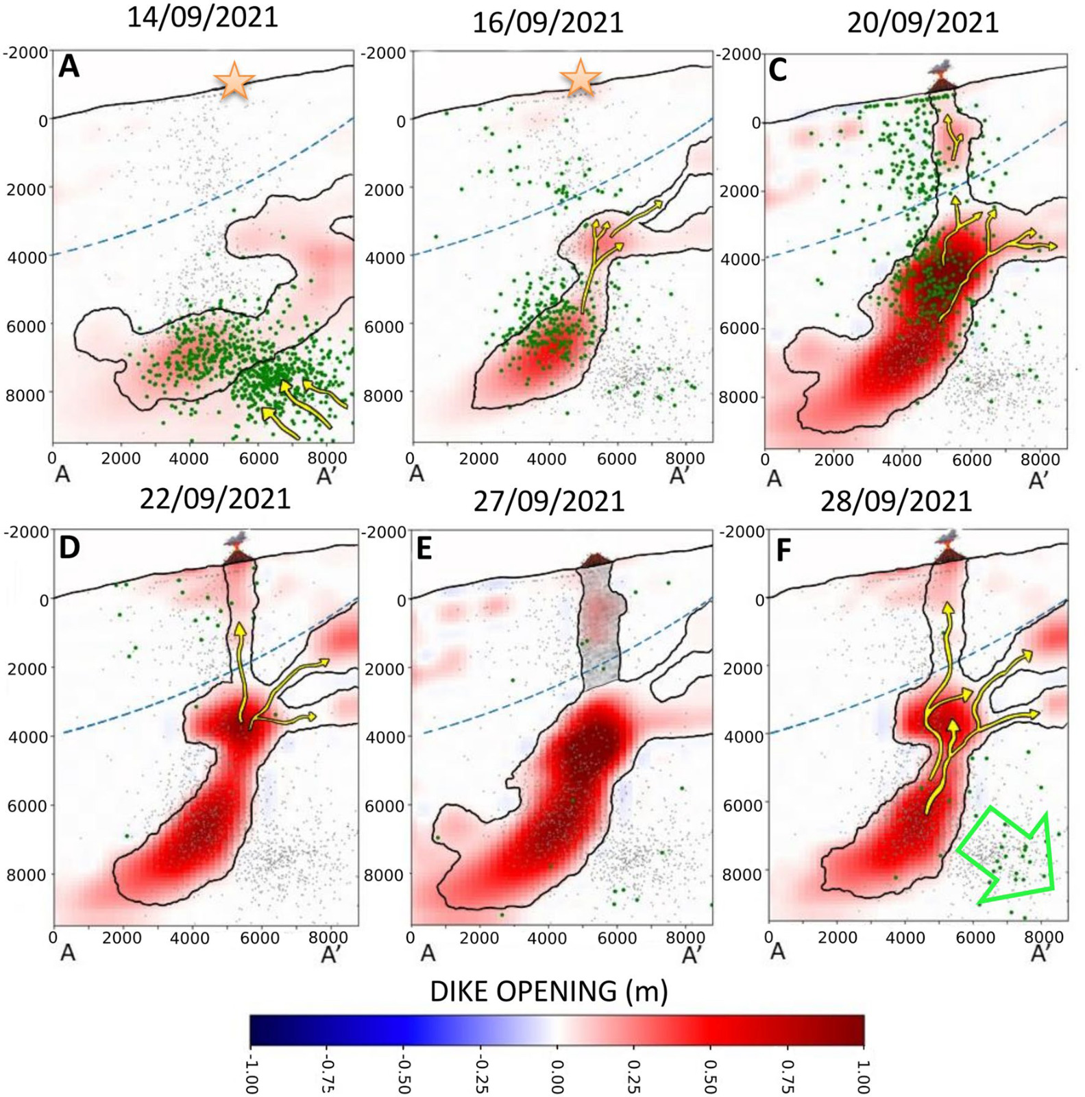
“The prelude to the eruption lasted 8 days and was characterized by precursory signals that manifested themselves starting from 11 September 2021,” explains Luca D'Auria, Geophysicist and Director of the INVOLCAN Volcanic Surveillance Area. “The seismicity, with migration towards the west and towards the surface of the hypocentres”, continues D’Auria, “anticipated the onset of the imminent eruptive event”.
The permanent GPS-GNSS stations, active on the island western side, have also recorded, starting from 12 September, ground deformations of more than 15 cm, offering significant indications of the evolution of the underlying magmatic pressure. After the start of the eruption, ground deformations then reached their maximum peak on September 22nd, showing a tendency towards deflation in the following months. In particular, the observations showed that, on September 27th, the eruption suffered a pause of a few hours attributed to a temporary collapse of the surface feeding system along the active fracturing system.
To fully understand the volcano dynamics, the research team used GPS-GNSS time series and satellite data from the European Sentinel-1 constellation, examining ascending and descending orbits. The resulting source geometry revealed a dyke, which is a sub-vertical, spatially articulated intrusive magmatic structure, bent towards the east. Specifically, the aforementioned power system conditioned the rise of magma along two main branches showing a close correlation with pre-eruptive seismicity, and was also influenced by the presence of a ductile and thermally anomalous layer beneath the volcano. In-depth analyzes also revealed early surface deformations attributed to the effects of ascending hydrothermal fluids.
These results underline the importance of advanced modeling for understanding pre-eruptive processes in complex basaltic volcanoes. “The geodetic analysis carried out” states the geophysicist Pietro Tizzani, senior researcher of CNR-IREA, “has demonstrated the great potential of this technique in the study of magma ascent processes”.
The researchers involved in the study concluded that these findings provide evidence of the complexity of fracturing propagation processes and temporal changes in a volcano's surface fuel system, opening new perspectives for understanding and mitigating risks related to future eruptions.
In the figure: Schematic model of the dynamics of the magmatic supply system (Volcano Plumbing System). The orange stars represent the position of the volcanic vent compared to the days preceding the eruption. The volcano symbols, instead, represent the actual position of the current volcanic vent. The yellow arrows represent the directions of magma rise, while the green arrow indicates the incipient collapse of the magma reservoir. The blue dashed lines represent the rheological boundary limit of the system under consideration.