
A further development, particularly important in urban areas, has had with the extension of the SBAS processing of SAR data at full spatial resolution (about 5-10 m) in order to detect deformation, even very localized spatially, showing a shift relative to the average of the ground.
The approach allows SBAS, therefore, to generate time series of deformation at two different spatial scales, defined at regional and local levels. The first exploits the SAR data at medium spatial resolution (pixel size of around 90-100 m), which allow you to generate maps of average speed and time series of deformation for the entire frame (typically around 100 x 100 km). At the local scale, the technique exploits the single-look interferograms generated at full spatial resolution (pixel size around 5-10 m), that identify and analyze localized deformation that may affect individual isolated buildings and structures. The SBAS approach requires two spatial scales, as a starting point, average soil deformation information generated from the analysis at the regional scale, which is appropriately subtracted from the interferograms at full spatial resolution to isolate the single component with high frequency, which must then be processed to extract the signal of deformation at high spatial resolution.
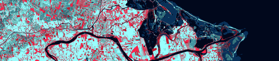
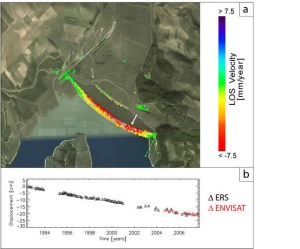
An example of the ability of the approach SBAS-DInSAR at full spatial resolution to identify highly localized deformation at the scale of the single structure is shown in Figure 1, which shows the map of strain rate at full spatial resolution, overlaid on an optical image of the dam on Lake Locone on data processing ERS-1 / 2 and ENVISAT orbits acquired by descendants during the period 1992-2007. And 'to note the precision with which it was possible to trace the deformation field at full resolution of the structure.
In this context, the current activity is mainly focused on the generation of time series of deformation at full spatial resolution using long sequences of SAR data acquired from multiple sensors, including sensors European ERS-1 / 2 and ENVISAT. One result of this type allows you to take full advantage of the archive of SAR data acquired by the sensors ERS and ENVISAT European Space Agency from 1992 to date and allows you to create very long time series of deformation related to a range of study even higher to 15 years, allowing, thus, to study deformation lenses in place for several years.
The approach allows SBAS, therefore, to generate time series of deformation at two different spatial scales, defined at regional and local levels. The first exploits the SAR data at medium spatial resolution (pixel size of around 90-100 m), which allow you to generate maps of average speed and time series of deformation for the entire frame (typically around 100 x 100 km). At the local scale, the technique exploits the single-look interferograms generated at full spatial resolution (pixel size around 5-10 m), that identify and analyze localized deformation that may affect individual isolated buildings and structures. The SBAS approach requires two spatial scales, as a starting point, average soil deformation information generated from the analysis at the regional scale, which is appropriately subtracted from the interferograms at full spatial resolution to isolate the single component with high frequency, which must then be processed to extract the signal of deformation at high spatial resolution.
An example of the ability of the approach SBAS-DInSAR at full spatial resolution to identify highly localized deformation at the scale of the single structure is shown in Figure 1, which shows the map of strain rate at full spatial resolution, overlaid on an optical image of the dam on Lake Locone on data processing ERS-1 / 2 and ENVISAT orbits acquired by descendants during the period 1992-2007. And 'to note the precision with which it was possible to trace the deformation field at full resolution of the structure.
In this context, the current activity is mainly focused on the generation of time series of deformation at full spatial resolution using long sequences of SAR data acquired from multiple sensors, including sensors European ERS-1 / 2 and ENVISAT. One result of this type allows you to take full advantage of the archive of SAR data acquired by the sensors ERS and ENVISAT European Space Agency from 1992 to date and allows you to create very long time series of deformation related to a range of study even higher to 15 years, allowing, thus, to study deformation lenses in place for several years.
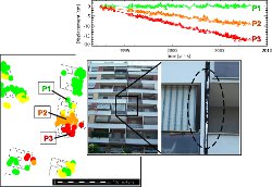 Results so far have shown the importance of having available data at high spatial resolution with short revisiting the lowest possible for the effective analysis of localized deformation at the scale of individual buildings. In this regard, the availability of SAR data acquired by new generation sensors, such as the Italian COSMO-SkyMed constellation and sensor TerraSAR-X, certainly has important implications on the study and monitoring of deformations affecting individual isolated buildings and structures. These sensors, operating in X-band, due to their high spatial resolution (about 3m and up to 1 m in the spotlight mode called), the geometric accuracy of images produced and the reduction of time revisiting the same satellites (about 8 days ) become for the monitoring of the territory, allowing a very thorough monitoring of urban areas, with the ability to detect differential movements of the buildings (movements intra-buildings).