News in evidence
Friday, 29 September 2017 12:03
Gloria Bordogna Fellow of the International Fuzzy Systems Association

During the World Congress of the International Fuzzy Systems Association (IFSA) held from June 27 to 30 in Otsu, Gloria Bordogna, Senior Researcher at IREA, was awarded the IFSA Fellow grade. The title, reserved reserved for distinguished contributors whose works have had a significant impact on fuzzy logic theory and…
Read 27712 times
Friday, 01 September 2017 14:05
European and Italian satellites measure the surface displacements induced by the Ischia earthquake
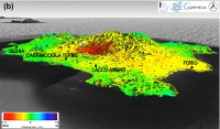
Immediately after the Ischia earthquake of 21 August 2017, researchers at CNR-IREA measured the Earth surface displacements thanks to the data acquired by the European Sentinel-1 and Italian COSMO-SkyMed constellations of satellites. A subsidence up to 4 centimetres was measured close to Casamicciola Terme. During the post-event phase, the Department…
Read 21228 times
Monday, 24 July 2017 15:18
Conference Europt(r)ode XIV
IREA, together with the Institute of Applied Physics at Carrara (IFAC-CNR) and the Italian Society of Optics and Photonics (SIOF), is organizing in Naples the XIV edition of Europt(r)ode, one of the most important Conferences worldwide in the field of optical sensors for chemical and biological applications. Submission of contributions…
Read 22849 times
Monday, 15 May 2017 15:17
Satellite radars and GPS detect slow fault movements
Revealed, for the first time in Italy, in the Pollino area, the presence of slow fault movements during a sequence of low magnitude earthquakes, which help to explain why in this area, compared to the rest of the Apennines, the earthquakes of higher magnitude are less frequent. The study was…
Read 41792 times
Tuesday, 14 February 2017 17:53
INSPIRE, from theory to practice: GET-IT software contributes to spatial data interoperability in Europe
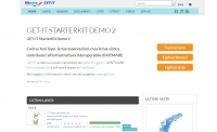
The GET-IT software was recently recognized a useful tool to make the INSPIRE Directive operational. GET-IT is now reviewed and registered in the “INSPIRE in Practice” catalogue. “INSPIRE in Practice” is the official INSPIRE platform dedicated to every user engaged in geographic information domain who would adopt tools contributing to…
Read 28435 times
Thursday, 02 February 2017 14:21
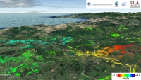
The Italy 18 January 2017 earthquakes captured by the Sentinel-1 and ALOS-2 satellite radar data
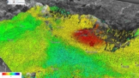
Despite the copious snow cover and the adverse weather conditions, the Sentinel-1 and ALOS-2 satellites allowed a team of IREA-CNR scientists to retrieve the Earth’s surface deformation induced by the recent seismic sequence in central Italy, whose main shock reached a magnitude of Mw 5.5 on 18 January 2017. Thanks to the…
Read 39998 times
Thursday, 15 December 2016 13:58
EDI Metadata Editor: a software for the management of spatial data

The National Directory of Territorial Data has reported EDI software as a new tool for all Public Administrations committed to enhancing their territorial data heritage. EDI, developed by IREA-CNR under the RITMARE project, responds in particular to the challenges of quality and coherence of geographic information by giving a variety…
Read 27594 times
Wednesday, 14 December 2016 11:56
Gianfranco Fornaro elevated to IEEE Fellow

Gianfranco Fornaro, Senior Researcher at IREA, has been elevated to Fellow by IEEE for his for contributions to SAR processing in differential interferometry and tomography. The Fellow grade will be effective by 1 January 2017. IEEE, “the Institute of Electrical and Electronics Engineers”, is the world's largest technical professional organization dedicated…
Read 26761 times
Monday, 21 November 2016 11:55
A European Geosciences Union Medal to Riccardo Lanari
Riccardo Lanari, director of IREA, has been announced as the recipient of the 2017 Christiaan Huygens Medal, one of the prizes that the European Geosciences Union (EGU) awards each year to eminent scientists for their outstanding research contribution to the Earth, planetary and space sciences. In particular, the Christiaan Huygens…
Read 25574 times
Wednesday, 02 November 2016 14:40
New results on the 30 October 2016 earthquake retrieved from the Sentinel-1 satellite radar data
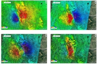
The study of ground deformation and seismic sources, now focused on the 30 October 2016 earthquake, is enriched with new important results obtained from the processing of radar images collected from the Sentinel-1 constellation along ascending and descending orbits Thanks to the new radar images, acquired on 1 November 2016 from…
Read 42233 times

Tag Cloud
IREA social
Research activity in evidence
-
Mircowave and terahertz sensors
The measurements of the dielectric properties of materials are subject…