
Maria Consiglia Rasulo
<
The mission of the Institute for Electromagnetic Sensing of the Environment is the development of methodologies and technologies for acquisition, processing, fusion and interpretation of images and data obtained by electromagnetic sensors - operating on satellite, aircraft and in situ - and the dissemination of information extracted, aimed at monitoring environment and territory, at non-invasive diagnostic and at electromagnetic risk assessment. In addition, methodologies and technologies are developed for the construction of infrastructures for geospatial data and biomedical applications of electromagnetic fields. Finally, activities of investigation, research and experimentation on the public communication of science are carried out, as well as activities on science education.
The Institute has consolidated expertise in the fields of optical and microwave remote sensing, diagnostics in situ for environment and territory, combined with the biological one for risk assessment from exposure to electromagnetic fields but also for their possible applications in medicine.
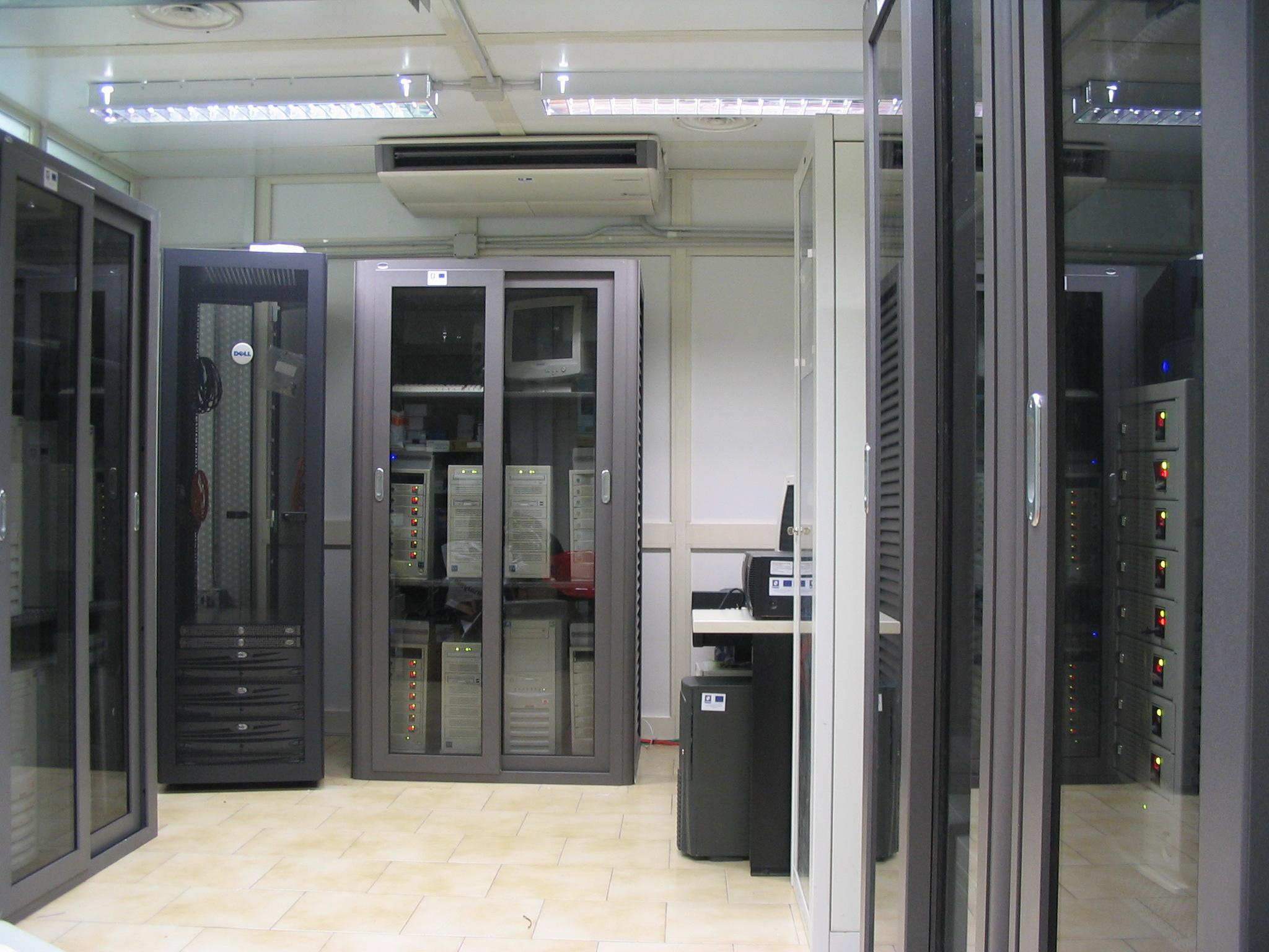 The cluster dedicated to Synthetic Aperture Radar (SAR) data processing has been designed and built at IREA with the aim to optimize the performance depending on the particular type of application. The processing of radar data, in fact, requires considerable disk space usage and a large number of data access operations. The system has a high degree of scalability and redundancy and is therefore intrinsically resistant to the partial failure of its components.
The architecture, composed of 16 compute nodes, is based on AMD Opteron 64-bit processors, quad-core for a total of 128 processing units (cores) and 512 GB of RAM. Each processing node, on which has been installed the 64-bit version of the Linux operating system, is equipped with a unit disk in Direct Attached Storage (DAS) and RAID 5. The total available disk space is currently about 90 TB.
 The airborne SAR platforms provide high operational flexibility, overcoming some limitations of satellite acquisitions. As a matter of fact, in some circumstances DInSAR by satellite cannot be fully adequate. Indeed, the orbits described by the satellites used for remote sensing applications do not allow measurements of ground deformation along the North-South direction. In addition, the time interval between two consecutive acquisitions of the same illuminated area on the ground (“revisiting time”) is fixed and does not allow monitoring deformation phenomena occurring on a daily scale, as required in emergency scenarios. Unfortunately, the extension of the DInSAR technique to airborne data is not trivial, due to the so-called residual motion errors that typically characterize the airborne SAR datasets.
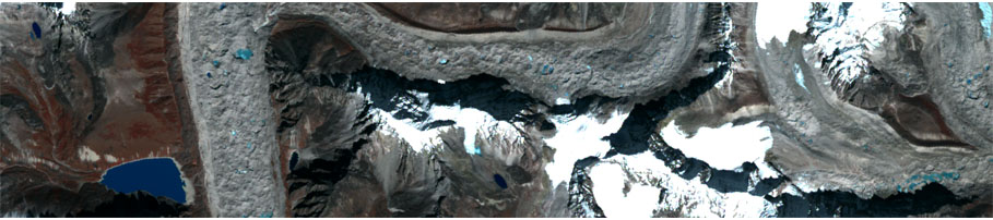
At IREA, several techniques have been developed to compensate residual motion errors in airborne SAR images. Such techniques have been applied to data acquired by the OrbiSar airborne sensor (operating at X-band) over the Perugia area during an experimental campaign organized in 2004 in collaboration with the Institute of Research for the Hydrogeological Protection (IRPI) of the National Research Council (CNR), the Vesuvius Observatory and the OrbiSat Remote Sensing company. This has allowed the generation of X-band airborne SAR differential interferograms characterized by accuracies of the order of millimeters.
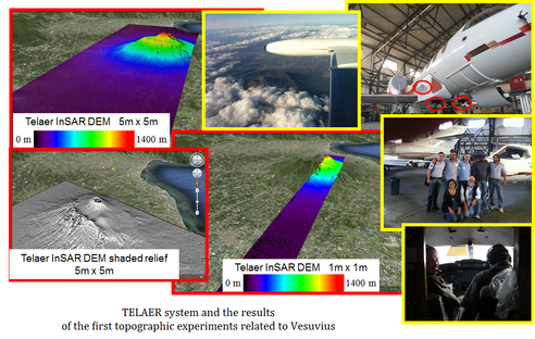
More recently, in order to successfully apply the aforementioned techniques also to Italian sensors, IREA has been involved in the upgrading of the AeS4 TELAER airborne SAR system operating at the X-band (10 GHz) and owned by the Agency for Agriculture Subsidy Payments (AGEA). In particular, CNR has funded (on its own MIUR funding) the upgrading of the TELAER SAR system in the frame of cooperation with AGEA. Moreover, CNR has entrusted IREA for managing all the activities related to such a system upgrading, included the flight-tests. The aim of this upgrading was twofold. First, the system, which was originally equipped with a single TX/RX antenna, has been upgraded to a single-pass interferometric configuration that allows carrying out single-pass across-track as well as along-track applications. Second, a modern inertial navigation system has been acquired for DInSAR applications.
The system upgrading has been completed in January 2013. Subsequently, a flight-test campaign has been carried out over the Somma-Vesuvius volcanic complex, the Campi Flegrei caldera and the Ischia island, Italy, covering an area of about 4000 km2 . The InSAR data processing of the acquired data has been carried out at IREA and has allowed the generation of Digital Elevation Models (DEMs) characterized by accuracies and resolutions on the order of the meter.
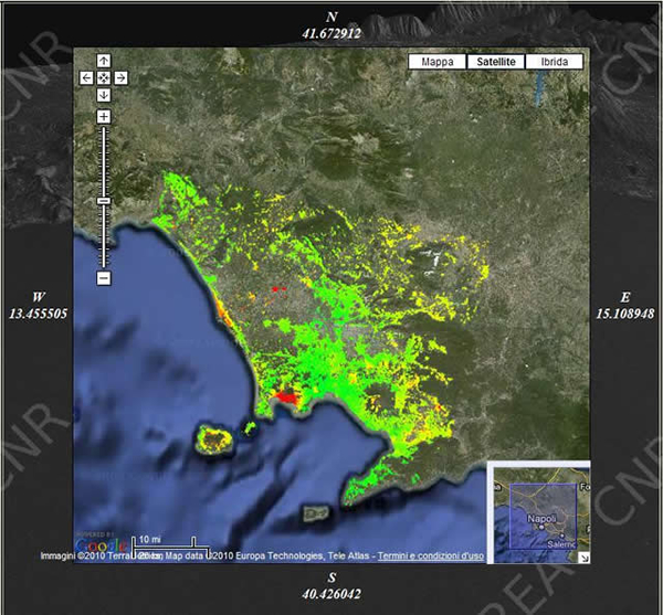
Thanks to an interface based on a GoogleMap technology, it is possible to access all the data concerning the earth deformation using satellite data very easily.
In the deformation maps the green dots represent the stable zones, while the red or purple ones indicate areas that have deformed. Clicking on any colored ball, you can see a graph showing the trend of the deformation over time (remember to unblock popups!)
Click on this link to see the results of some areas where we processed the data:
The analysis of data relating to IREA funding and scientific output in the period 2013-2016 shows both a remarkable ability to find external financial resources, resulting from participation in national and European research projects, cooperation with industry, and a high scientific output, characterized by publications in the most prestigious journals in their respective sectors, confirming a trend of steady improvement over time of these fundamental parameters, as evidenced by the two graphs reported below

A positive picture comes out as regards the Institute functioning and climate, the ability to exploit its specific multi-disciplinary and interact with the scientific and socio-economic reality, the motivation and productivity of researchers.
The remarkable level reached is evidenced by the outcome of the Evaluation of the Research Quality (VQR) conducted by the ANVUR (National Agency for Evaluation of Universities and Research Institutes) for the period 2011-2014, whose trial ended in November 2015. This evaluation placed IREA among the institutes of excellence in the CNR.
The Institute for Electromagnetic Sensing of the Environment (IREA) was founded in 2001 as a result of the reorganization process of the National Research Council of Italy (CNR), from the union of Electromagnetism and Bioelectromagnetism departments of the Research Institute for Electromagnetism and Electronic Components (IRECE) in Naples and Remote Sensing department of the Research Institute for Seismic Risk (IRRS) in Milan.
In these Institutes research activities focused on remote sensing, diagnostics, and monitoring of environmental risk, with particular reference to the electromagnetic one, were well-established, with a significant recognition at national and international level.
The merging of the scientific know-how produced a new reality within CNR, which, over the years, has proved its value in the national and international research scenery. The remarkable level reached is demonstrated not only by the high scientific production, characterized by publications in the most prestigious journals in their respective sectors, but also by the evaluation of the CNR institutes, carried out by 150 Italian and foreign experts and whose process ended in 2010. The final results of this evaluation, which examined the scientific production, ability to attract external funding, infrastructure and human resources, placed IREA among the top 20 institutes of excellence in CNR.