
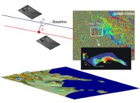
Earthquakes, landslides, volcanic eruptions, or, more generally, deformation phenomena of the earth's surface, can be monitored through the use of Synthetic Aperture Radar (SAR) sensors.
The SAR is able to revisit the same area at regular intervals, providing information at very high spatial resolution of the observed scene. In the case of ERS 1 / 2 and Envisat European Space Agency (ESA), active since 1992 has set the time to review every 35 days, while for the new generation sensors such as the constellation Cosmo Sky-Med, the interval was reduced to 8 days. Using the technique known as SAR Interferometry (InSAR), in which you compare (they do "interfere") two images acquired from slightly different positions (spatial baseline) you can get three-dimensional images of the Earth's surface, measuring the topography. When images are acquired in different times (temporal baseline), using the Differential SAR Interferometry (DInSAR) technique, it is possible to measure the changes of the surface. These measures are shown by a series of colored bands, the so-called fringes or interferogram. The electromagnetic waves used are characterized by an alternation of crests spaced about 5 cm, this distance is called the wavelength. It is "counting" these crests that the radar is able to understand how far is the object he is observing. Not only that, if the object, which can also be located hundreds of miles away, moving only a few centimeters, the number of crests that characterize the electromagnetic waves will change, allowing you to detect and accurately measure the displacement with centimetric accuracy.
The interferometric techniques produce not only the maps of ground deformation measured along the line of sight of the sensor, but taking advantage of a series of images (instead of only two) acquired over time, allow us to follow the itself temporal evolution of deformation. For example, the measurement of ground deformation in volcanic areas is extremely important because these are often precursors of eruptions, or however indicate an increase of volcanic activity. And when you consider that the first satellites used for this purpose have collected data since 1992,the deformation history of a volcano in the last 19 years can be analyzed with a previously unimaginable detail. Moreover, as a further advantage compared to the more "traditional" techniques especially in case of eruption, these measurement are obtained without any necessity of access to the volcano.
Traditional techniques include manual data collection to be made by measurement campaigns in the area, or the installation, at fixed locations,of GPS receivers. In both cases, the number of measurement points will be limited.
A satellite deformation map, however, can cover large areas and with a very high density of measurement.
Earthquakes, landslides, volcanic eruptions, or, more generally, deformation phenomena of the earth's surface, can be monitored through the use of Synthetic Aperture Radar (SAR) sensors.
The SAR is able to revisit the same area at regular intervals, providing information at very high spatial resolution of the observed scene. In the case of ERS 1 / 2 and Envisat European Space Agency (ESA), active since 1992 has set the time to review every 35 days, while for the new generation sensors such as the constellation Cosmo Sky-Med, the interval was reduced to 8 days. Using the technique known as SAR Interferometry (InSAR), in which you compare (they do "interfere") two images acquired from slightly different positions (spatial baseline) you can get three-dimensional images of the Earth's surface, measuring the topography. When images are acquired in different times (temporal baseline), using the Differential SAR Interferometry (DInSAR) technique, it is possible to measure the changes of the surface. These measures are shown by a series of colored bands, the so-called fringes or interferogram. The electromagnetic waves used are characterized by an alternation of crests spaced about 5 cm, this distance is called the wavelength. It is "counting" these crests that the radar is able to understand how far is the object he is observing. Not only that, if the object, which can also be located hundreds of miles away, moving only a few centimeters, the number of crests that characterize the electromagnetic waves will change, allowing you to detect and accurately measure the displacement with centimetric accuracy.The interferometric techniques produce not only the maps of ground deformation measured along the line of sight of the sensor, but taking advantage of a series of images (instead of only two) acquired over time, allow us to follow the itself temporal evolution of deformation. For example, the measurement of ground deformation in volcanic areas is extremely important because these are often precursors of eruptions, or however indicate an increase of volcanic activity. And when you consider that the first satellites used for this purpose have collected data since 1992,the deformation history of a volcano in the last 19 years can be analyzed with a previously unimaginable detail. Moreover, as a further advantage compared to the more "traditional" techniques especially in case of eruption, these measurement are obtained without any necessity of access to the volcano.Traditional techniques include manual data collection to be made by measurement campaigns in the area, or the installation, at fixed locations,of GPS receivers. In both cases, the number of measurement points will be limited.
A satellite deformation map, however, can cover large areas and with a very high density of measurement.
