
 Sentinel-1 is the first satellite of the Copernicus program and is equipped with a Synthetic Aperture Radar (SAR) sensor that is able to provide day-night acquisitions nearly over the whole World. The Sentinel-1 operational mode on land is the so-called Interferometric Wide Swath (IWS), which guarantees the Earth’s global coverage with a revisit time of 12 days, thus making Sentinel-1 as a powerful system for surface displacement monitoring at global scale through Interferometric SAR (InSAR) technique.
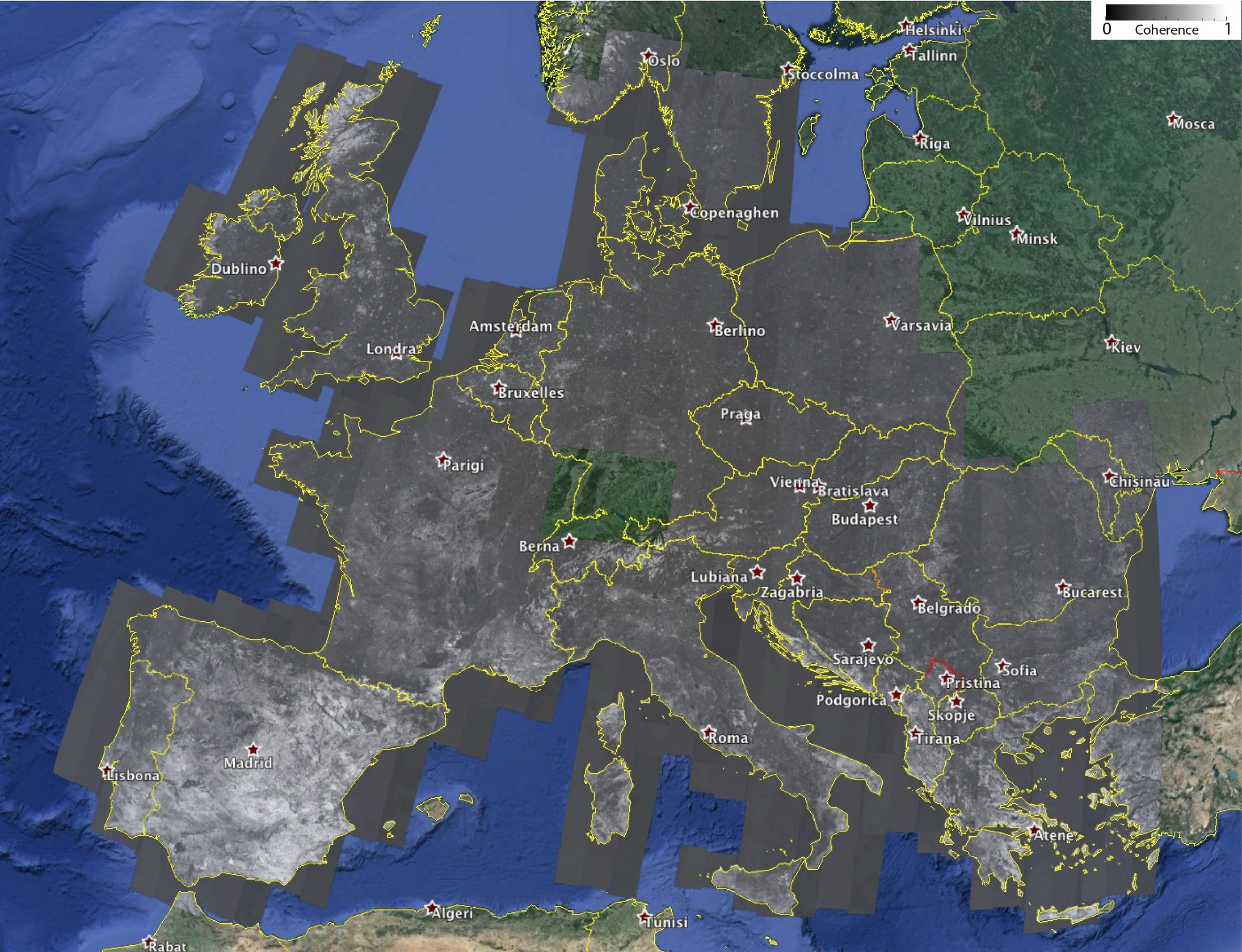
In this context, scientists of IREA-CNR processed 380 Sentinel-1 imagery, acquired over Europe during the June-July 2015 period and coupled in 190 12-days interferometric pairs with 2 looks in azimuth and 10 in range, with the final aim to analyse the InSAR characteristics of the European Continent. Such a study permits to assess the Sentinel-1 InSAR performances as well as to have an idea of the expected InSAR measurements quality over the Europe. As a result, in Figure 1 the 12-days Interferometric Coherence map of almost the entire Europe is shown; note that white and black areas correspond to high (close to 1) and low (close to 0) coherence values, respectively.
“This work demonstrates the high capabilities of Sentinel-1 system for surface displacement detection at global scale”, states Francesco Casu, researcher at IREA-CNR, “and represents the first step towards the generation of continental scale Earth’s surface deformation maps and time series”.
This study has been carried out by exploiting the automated and unsupervised IREA-CNR processing tools integrated within the Geohazards Exploitation Platform (GEP), an ESA initiative for fostering the creation of a novel and dynamic scientific environment where are at user disposal, at the same time and in the same place, data, computing facilities and processing tools.
“The GEP environment, that hosts the IREA-CNR InSAR tools freely accessible to the scientific community”, says Michele Manunta, researcher at IREA-CNR, “permits researchers to change the way they do science, opening new scenarios in terms of data access, processing capacity and result sharing, thus fostering the creation of knowledge”. Within the GEP, the main IREA-CNR task is to set-up an automated service for the systematic generation and update of SBAS-InSAR displacement time series originated from Sentinel-1 data.
This study, realized with the support of the ESA GEP, TEP-QW and G-POD projects, as well as of the Italian Department of the Civil Protection, paves the way for the implementation, in the near future, of new services and products addressed to the scientific community (as for instance the EPOS one), as well as to the National Departments of Civil Protection.
