
The study of the ground deformations and seismic sources related to the events of 24 August 2016 is going on. Thie activity is coordinated by the Department of Civil Protection (DPC) and is carried out by a team of researchers from the National Research Council (Institute for Electromagnetic Sensing of the Environment, CNR-IREA of Naples) and the National Institute of Geophysics and Vulcanology (INGV), centers of competence in satellite radar data processing and seismology, respectively, with the support of the Italian Space Agency (ASI).
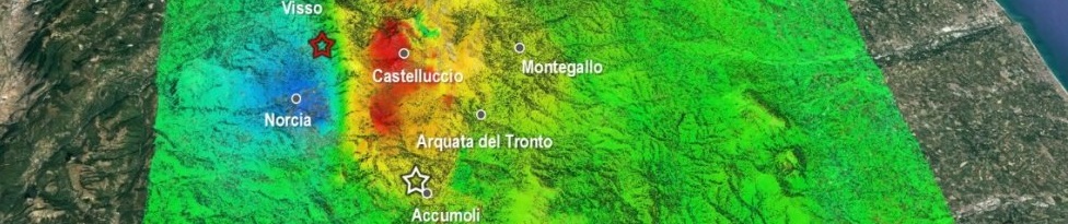
After the first products obtained by using the radar data of the Japanese satellite ALOS 2, the analysis has also been enriched by the results of radar image processing obtained most recently by sensors (operating in C-band) of the Sentinel-1 constellation of the European Copernicus program and those (operating in X-band) of the Italian constellation COSMO-SkyMed developed by the Italian Space Agency in co-operation with the Ministry of Defense. In particular, applying the Differential SAR Interferometry technique to the joint use of Sentinel-1A and Sentinel-1B images acquired by ascending (South-North) and descending (North-South) orbits, it was possible to estimate the ground displacements along the two lines of sight of the radars, and from these, to extract the vertical and east-west components of deformations (Figure 1). The obtained results confirm the ground subsidence with the characteristic shape of a "spoon" that extends for about 20 km northwards, already observed from the analysis of ALOS 2 data, with a deformation of about 20 cm located at the area of Accumoli. Note also that the East-West component concerns an area larger than the vertical one (about 20 x 25 km2); it is characterized by the presence of four alternating displacement areas (blue towards the west and red toward the east, as shown in Figure 1), with maximum deformation values of about 16 cm westward.

Figure 1. At the top are the two co-seismic deformation maps (in the radar view lines) obtained from ascending and descending orbits, with the Differential SAR Interferometry technique, starting from the Sentinel-1A and 1B radar data acquired on 15/08/2016 and 21/08/2016 (pre-event images) and 27/08/2016 (post-event images). Below are shown the maps of the vertical and east-west components of the ground displacement, obtained by jointly using ascending (South-North) and descending (North-South) passages. The blue line represents the trace on the ground of the fault.
In addition to Sentinel-1 data, CNR and INGV researchers benefited from the radar acquisitions of the Italian constellation COSMO-SkyMed X-band sensors. It is emphasized that, thanks to the high spatial resolutions of this system, it is possible to obtain information on the ground deformation pattern with a great spatial detail. In this regard, Figure 2 shows the map of co-seismic deformation, generated from radar data acquired on descending orbits on 20/08/2016 (pre-event) and 28/08/2016 (post-event), relating to the zone stretching from Tufo and Pescara del Tronto to the area of Castelluccio. Note that the best spatial resolution also allows identifying localized deformation effects (landslides, reactivated faults) such as, for example, the ground displacement (identified by the arrow in Figure 2) relating to an area extending approximately 800 x 600m on the side of Mount Vettore, probably linked to a slope instability. The information obtained is particularly relevant for the analysis of geological and geophysical processes underway and for the study of the fault behaviour through the development of advanced physical-mathematical models.

