
Monitoring crustal deformation in active volcanic areas could not be an easy task. Space-borne remote sensing can make the difference with respect to in-situ techniques, due to its capability to provide dense measurements at large spatial scale and at relatively low cost. These results will be presented on April 9th during a scientific talk (Room M2 at 9:30) and a press conference (at 13:00) at the next European Geophysical Union (EGU) General Assembly that will be held from 7th to 12th April in Vienna.
Differential Synthetic Aperture Radar Interferometry (DInSAR) is becoming one of the usual techniques to measure ground deformation with high accuracy and in any atmospheric conditions. The increasing diffusion of the use of DInSAR is due to the recent availability of huge and easily accessible SAR data archives, as those provided, since late 2014, by the Copernicus Sentinel-1 constellation. Sentinel-1 is nowadays providing SAR data every 6 days (in the best case) all over the Earth. It is therefore clear that with such a huge, global, constant and reliable availability of data it is possible to use the DInSAR technique for monitoring purposes, such as those related to the measurements of the ground motion in volcanic areas.
Researchers at the Institute of Electromagnetic Sensing of Environment (IREA) of the Italian National Research Council (CNR) have developed an operative service for monitoring the crustal deformation in active volcanoes through the use of DInSAR technique and Sentinel-1 data. The designed system is fully automatic and the process is triggered by the availability, for every monitored volcano site, of a new acquired Sentinel-1 data. The satellite data are ingested and processed through the well-known Parallel Small BAseline Subset (P-SBAS) DInSAR technique (fully developed at IREA-CNR) in order to generate the displacement time series of the investigated area.
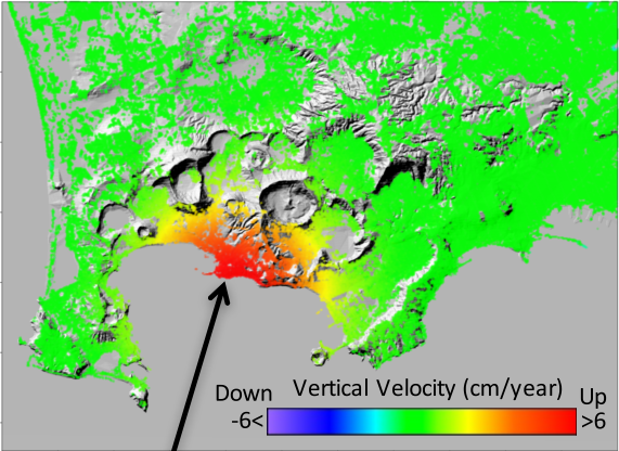
Being a Center of Competence (CoC) of the Italian Department of Civil Protection (DPC), CNR-IREA operates the described service to monitor the ground deformation of the main active Italian volcanoes, such as the Campi Flegrei caldera, Mt. Vesuvius, Ischia, Mt. Etna and Stromboli and provides monthly updates on the volcanoes’ deformation statuses to DPC and others CdC devoted to volcano monitoring. As an example, in the figure is reported the ground deformation affecting the Campi Flegrei caldera, near the city of Naples (Italy), which is experiencing an uplift of about 8.5 cm/year since July 2017.
Although the service is intended to serve the Italian DPC, it has been built to be easily portable and replicable for other volcanoes in the Earth, thus fully benefiting from the DInSAR monitoring capabilities of Sentinel-1.
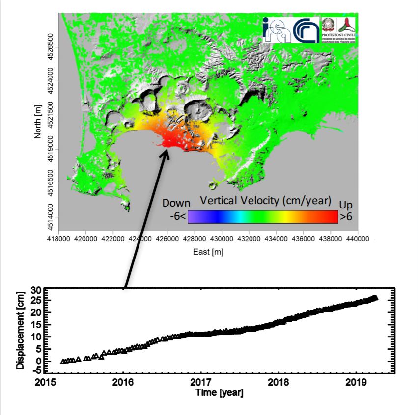
The graph shows the temporal evolution of the deformation that, since March 2015, uplifted of about 25 cm. Contains modified Copernicus data ©2019.
This work is supported by the IREA-CNR and Italian Civil Protection Department 2019-2021 agreement, the H2020 EPOS-IP project (GA 676564), the I-AMICA (PONa3_00363) project, and the IREA-CNR/DGS-UNMIG agreement.
