
 What produced the recent Mount Etna volcanic-tectonic crisis, culminating with the ML 4.8 earthquake occurred along the Fiandaca Fault on the southeastern flank of the volcano? The main cause could be the ascent of deep magma, which could have put under tension the flanks of the volcano, triggering relevant seismic swarms along the Ragalna Fault System (southwest flank), the Pernicana Fault System (northeast flank) and, more violently, along the Fiandaca Fault (southeast flank), where the seismic swarm also produced a widespread surficial faulting and damage. The same ascent of deep magma could also have triggered the brief eruption of Mount Etna on 24-27 December 2018; the entire intrusive and deformative process may not have been completely exhausted (Figure 1 on the left).
This hypothesis is formulated in a study conducted by a team of researchers from the Institute for Electromagnetic Sensing of the Environment of the National Research Council (IREA-CNR, Naples) and the National Institute of Geophysics and Volcanology (INGV, Catania and Rome), in collaboration with the Department of Civil Protection (DPC, Rome).
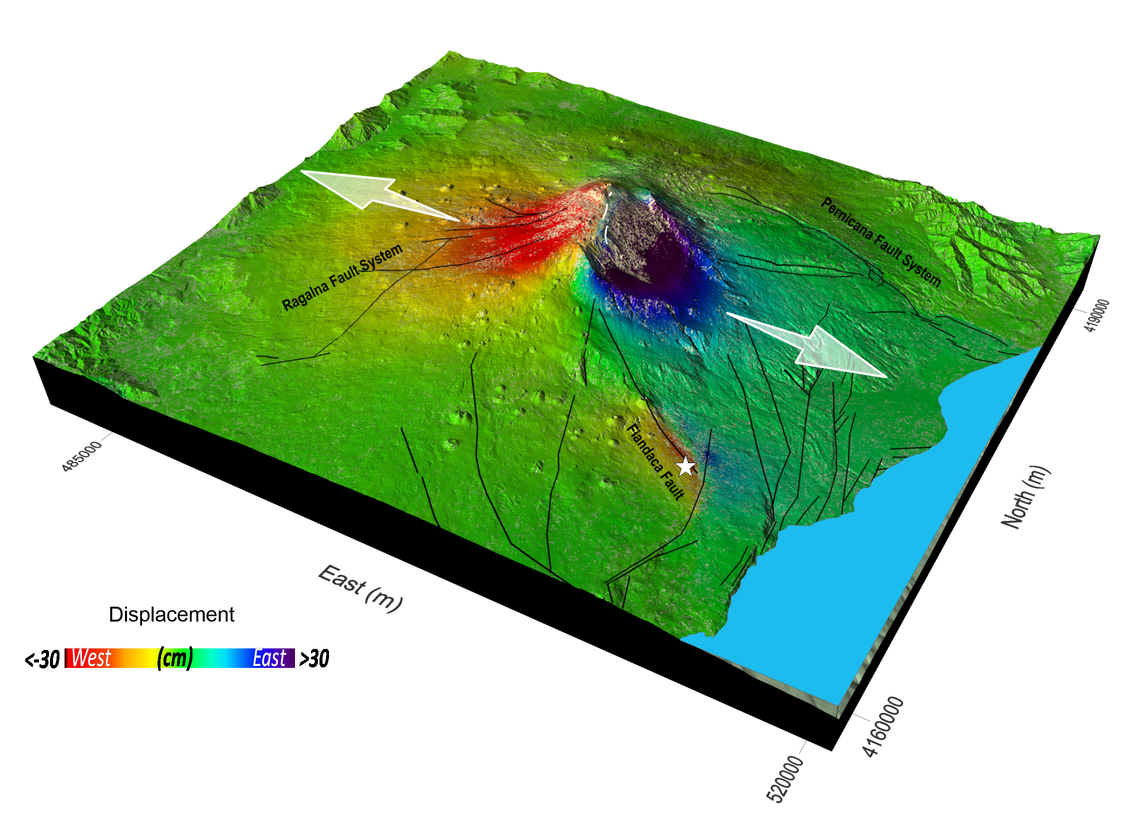
The results of this research are based on the analysis of the radar images of the Sentinel-1 satellites belonging to the constellation of the Copernicus European program, processed through the interferometric technique (InSAR), with which the Mount Etna ground deformations induced by the eruptive and seismic activity were measured with centimetre accuracy. "The availability of satellite radar data of the Sentinel-1 constellation, from the Copernicus European program, and of the COSMO-SkyMed constellation of the Italian Space Agency (ASI) and the Ministry of Defense", highlights Riccardo Lanari, director of IREA-CNR, "has allowed detecting in detail the ground movements that affected the Mount Etna volcanic edifice during the 24-27 December 2018 eruption. The identification of both magmatic and seismogenic sources, which caused the deformations detected by satellites, has been possible thanks to a multidisciplinary approach, which integrated the seismological and field data with the satellite radar data processed by IREA-CNR " (Figure 2).
Through a process called "data inversion" and with the help of mathematical models, the volcanic and seismic sources that generated the deformations were reconstructed, succeeding in demonstrating the causal link between eruption and earthquakes. "The analytical modeling", says Vincenzo De Novellis, IREA-CNR researcher "has allowed us to distinguish two different deformative sources connected with the magma intrusion: a very surficial one, which caused the opening of the observed cracks from which the lava has flown, and a deeper one (from 3 to 8.5 km) which exercised a tension on the volcano flanks, triggering the fault movement and, therefore, generating the numerous earthquakes recorded by the monitoring network of the INGV ” (Figure 3).
"That the strong subsidence of the area close to La Montagnola (about 3 km south of the Mount Etna summit crater area) was a secondary effect of the deep magmatic intrusion was only understood thanks to the analytical modeling" adds Simone Atzori, INGV researcher. "With the same technique," continues Atzori, "we have analyzed and quantified the interactions that occurred between the magma ascent and the surrounding faults, including the Fiandaca, Pernicana and Ragalna structures".
"Understanding the cause-effect relationships between magmatic intrusions and earthquakes has always been an extremely interesting scientific challenge, first of all for the implications that these studies have on the evaluation of seismic and volcanic hazard", concludes Marco Neri, senior researcher at INGV. "And it is not said that it is effectively concluded. By comparing the large ground deformations occurred in the last few months and the small eruption of December, we can suppose that the volcano still has energy to spend. These are important assessments, especially for a densely urbanized area such as the Mount Etna one, where almost a million people live in close contact with one of the most active volcanoes in the world”.
The results of this research, entitled "DInSAR analysis and analytical modeling of Mt. Etna displacements: the December 2018 volcano-tectonic crisis", have just been published on the American journal Geophysical Research Letters (https://doi.org/10.1029/2019GL082467) and are now available to the scientific community and Civil Protection, which has also contributed to the publication: these results will represent a reference point to improve risk estimation in an area with such a high population density.
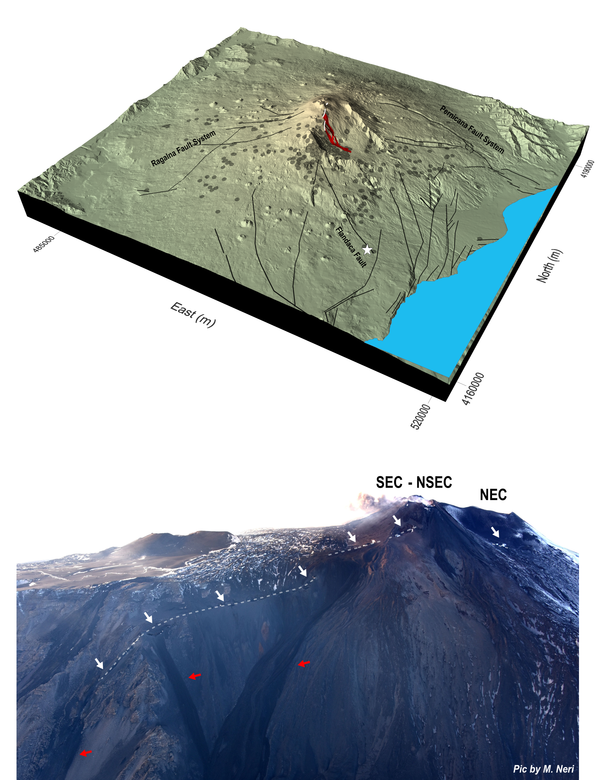
Figure 1. Above: Three-dimensional view of Mount Etna showing the eruptive fissures (white lines) from which the lava (in red) has flown on 24 December 2018, the main structural features of the volcano (black lines) and the 26 December earthquake (white star). The grey circles represent the epicentres of the earthquakes that nucleated from 24 to 27 December. Bottom: photograph acquired during a helicopter flight from west to east, in which it is possible to recognize the eruptive fissures (white dashed lines) and the main lava flow emerging from the cracks (red arrows). SEC: Southeast Crater; NSEC: New Southeast Crater; NEC: Northeast Crater.
|
Figure 2. Three-dimensional view of the horizontal component (in East-West direction) of the reconstructed ground displacements through the analysis of the radar images of the Sentinel-1 satellites belonging to the constellation of the Copernicus European program. The two white arrows indicate the direction of the displacements whose maximum values exceed 30 cm towards west and 50 cm towards east on the top of the volcano. In the area near the epicentre of the 26 December earthquake (white star), the maximum eastward ground displacement is 14 cm, while the corresponding westward shift is of 17 cm. |
|
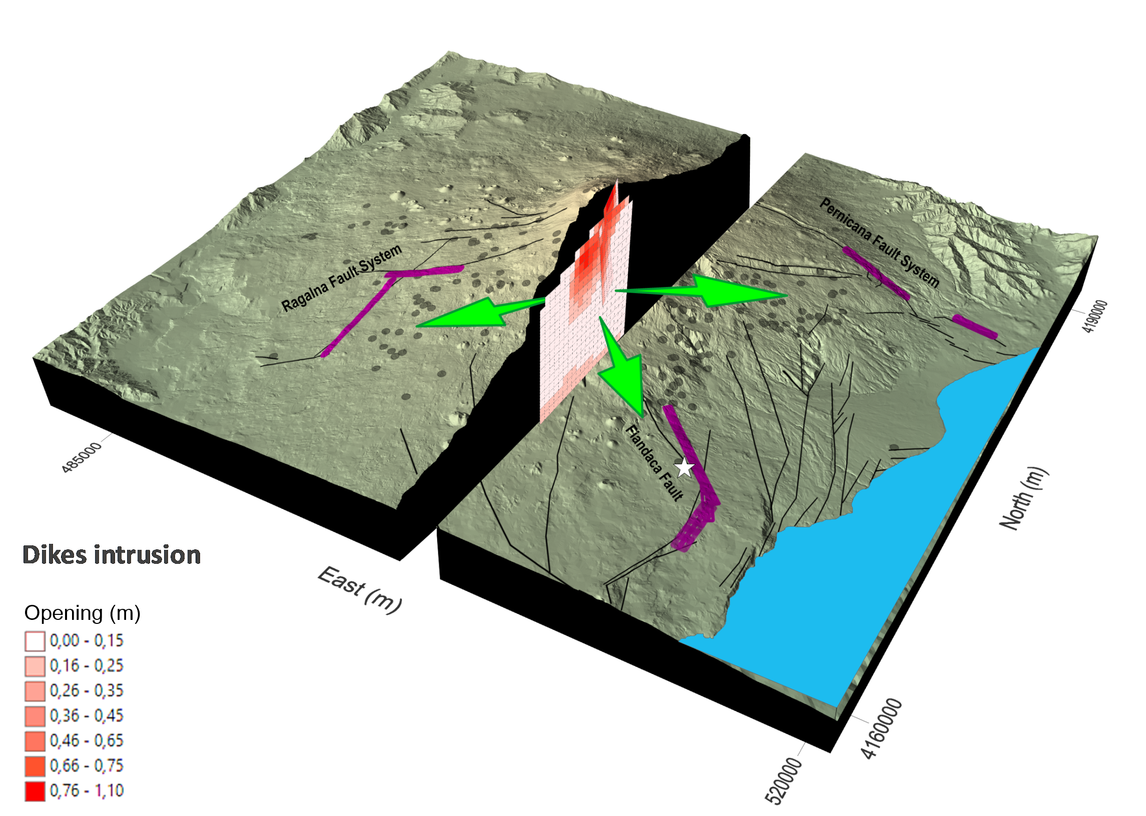
Figure 3. Three-dimensional view of Mount Etna, which summarizes the results of the model related to the volcano-tectonic events of December 2018. In the cutaway the two modelled magmatic bodies (dikes) were represented: a more surficial one, which caused the opening of the cracks from which the lava flow came out, and a deeper one, which exerted tension on the flanks of the volcano. The small squares that composed the modelled dikes indicate the greater presence (in red) or smaller (in light pink) of magma. The purple lines represent the fault planes calculated by the model, while the black ones represent the tectonic structures that actually emerge on the surface. Finally, the green arrows schematize the pressures exerted by magmatic intrusions, which should have "triggered" the movement of the faults, including the Fiandaca Fault along which the 26 December earthquake occurred (the epicenter is indicated with the white star). |
See the presentation of the results to this link
