
A recent analysis relating to the Morandi bridge shows the absence of deformations, before its collapse, in the results obtained from the satellite radar data of the Italian COSMO-SkyMed constellation. This evidence has been shown by a study conducted by a team of researchers from the CNR Institute for Electromagnetic Sensing of the Environment and published in Remote Sensing. The results are in contrast to previous findings published in the same journal.
On 14 August 2018, the bridge over the Polcevera stream on the A10 Genoa-Savona motorway, built on a design by the engineer Morandi in the 1960s, collapsed, resulting in the death of 43 people.
Following the tragic event, a team of researchers from the Institute for Electromagnetic Sensing of the Environment (IREA, Naples) of the National Research Council (CNR) conducted an in-depth study, based on the processing of satellite radar data, on possible pre-collapse movements associated with the area affected by the disastrous event, as part of the activities carried out as a Center of Competence for the Italian Civil Protection Department for the study of ground deformation phenomena through satellite measurements.
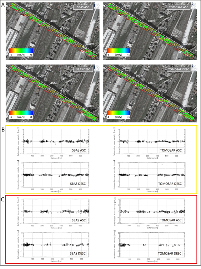
"The processing through advanced InSAR techniques of SAR data acquired by the COSMO-SkyMed constellation of the Italian Space Agency in the period immediately preceding the collapse (January 2011 - August 2018)" explains Riccardo Lanari, acting director of the CNR-IREA, "allowed us to generate deformation time series relating to the viaduct area which revealed the absence of significant surface movements precursors of the collapse of the bridge."
"The characteristics of these sensors, particularly the very high spatial resolution (a few m) and the very short wavelength (about 3 cm)" adds Diego Reale, an IREA researcher participating in the team, "made it possible to carry out a detailed analysis of the deformations relating to a complex infrastructure such as the Morandi bridge, in terms of density of measurement points and the ability to monitor the behavior of the entire structure, with millimeter accuracy."
"The products of the interferometric processing obtained using two independent and alternative approaches, such as the Small BAseline Subset (SBAS) technique and the SAR Tomography technique, showed a significant consistency and similarity between them, in terms of both spatial coverage and extent of measured deformation ”underlines Manuela Bonano, another IREA researcher member of the team, "confirming the substantial absence of superficial movements that were precursors of the collapse of the Morandi bridge."
The results obtained were presented in the work entitled “Comment on “Pre-Collapse Space Geodetic Observations of Critical Infrastructure: The Morandi Bridge, Genoa, Italy”, by Milillo et al. (2019)”, published in the same scientific journal Remote Sensing in December 2020.
Cover photo: LaPresse
