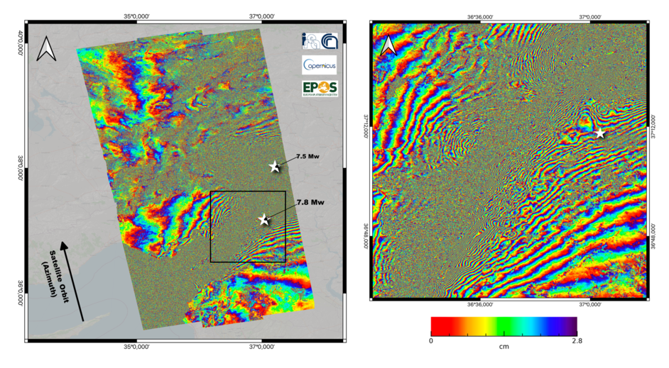
 Following the two seismic events of February 6, 2023, that devastated South-East Turkey and Northern Syria and caused tens of thousands of victims and incalculable damage, a team of researchers from the Institute for Electromagnetic Sensing of the Environment of the National Research Council (IREA-CNR) has detected the surface deformation field induced by the considered seismic events by applying the Differential SAR Interferometry (DInSAR) technique. This result has been achieved thanks to a system developed by IREA-CNR as part of EPOS (European Plate Observing System) activities, the European research infrastructure for the solid Earth study. This system makes it possible to generate DInSAR products automatically, following particularly significant seismic events.
In particular, a co-seismic interferogram was generated (see Figure 1) by analyzing the radar images of the European Sentinel-1A sensor that operates at a wavelength of about 5.6 cm in the C-band of the microwaves. The images were acquired on January 28 and February 9, 2023. Each "fringe" of the interferogram in the Figure, i.e. each color cycle, corresponds to a shift in the sensor Line Of Sight (LOS) of about 2.8 cm, equal to half the wavelength used. The investigated area extends for 130,000 Km2, of which about 35,000 are affected by significant deformation phenomena testified by the presence of interferometric fringes that in many areas are very dense (see the zoom in Figure 1) due to the displacements, even of several meters, caused by seismic events.
New images of the Sentinel-1A sensor, taken from different orbits, are expected in the next few days and will allow further analyses. Furthermore, a series of acquisitions of radar images carried out by the radar sensors of the Argentine constellation SAOCOM-1, operating in the L-band of microwaves with about 23 cm of wavelength, have already been programmed in collaboration with the Italian and Argentine Space Agencies. They will further extend the results obtained thanks to the analysis based on Sentinel-1A data.
The generated results will be made available through the EPOS portal
Sentinel-1 data was provided through the European Copernicus programme
Figure 1: Sentinel-1 co-seismic interferogram relating to the acquisitions of January 28 and February 9, 2023, carried out along ascending orbits. The image on the right shows a zoom relative to the area corresponding to the black box. The white stars indicate the position of the epicenters of the two seismic events of magnitude 7.8 and 7.5 that occurred on February 6, 2023.


