
Maria Consiglia Rasulo
-
October 24, 2021. Submission of regular papers and SRC research abstracts
- October 25, 2021. Submission of tutorial proposals
-
November 20, 2021. Notification of tutorials acceptance
-
December 10, 2021. Notification of paper acceptance/rejection
-
December 10, 2021. Notification of SRC acceptance/rejection
-
December 21 , 2021. Camera-ready copies of accepted papers/SRC
-
December 21, 2021 Author registration due date
-
April 26, 2022. SRC Poster exhibit
-
April 27, 2022. SRC Non-SRC Poster program
-
April 28, 2022. SRC Oral presentation
For further information, download the Call for Papers

Call For Papers for the Special Issue "Data Fusion for Remote Sensing of Fires and Floods in the Sentinels Era" of the MDPI Remote Sensing.
Guest Editors: Gloria Bordogna e Daniela Stroppiana
Deadline for manuscript submissions: 30 December 2021.
On 29 December 2020 (11:19:54 UTC), a Mw 6.4 earthquake struck the central Croatia, close to the town of Petrinja, killing seven people, injuring hundreds, and causing widespread damage. This is the largest earthquake occurred in Croatia since the advent of modern seismometers.
This event nucleated along a right-lateral strike-slip fault, known in literature as Petrinja fault, and was preceded by two earthquakes of magnitude 4.7 and 5.2, which occurred on 28 December. In the following hours and days, there were also numerous aftershocks that reached a maximum magnitude of 4.8.
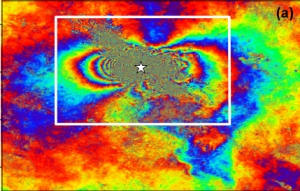
By using the Differential Synthetic Aperture Radar Interferometry (DInSAR) technique, a team of researchers at the Institute for Electromagnetic Sensing of the Environment of the National Research Council of Naples (IREA-CNR) has studied the surface deformation field induced by the considered seismic event. In particular, the data employed to generate the co-seismic interferograms were acquired by the European satellite Sentinel-1 on 18 and 30 December 2020 and on 23 December 2020 and on 4 January 2021 along ascending and descending orbits, respectively (Figure 1a and 1b). Each fringe corresponds to a LOS-displacement of about 2.8 cm, with a maximum deformation of about 40 centimeters.
Starting from these interferograms, the corresponding deformation maps were then derived (Figure 1c and 1d) through appropriate phase unwrapping procedures. In particular, the ascending track (Figure 1c) presents a deformation pattern characterized by LOS negative values down to about −32 cm and LOS positive values up to about 38 cm, indicating a sensor-to-target distance increase and decrease, respectively; moreover, the descending track (Figure 1d) shows a deformation pattern characterized by both negative LOS displacement values down to about −16 cm and positive LOS displacement values up to about 29 cm.
The availability of both ascending and descending SAR dataset and their consequent combination allow to discriminate the vertical and east–west components of the displacement. In particular, the vertical displacement map shows (Figure 1e) an area affected by a maximum subsidence of -13 cm and an uplifted one with maximum values of 19 cm; moreover, the horizontal displacement map shows a maximum displacement of 43 cm to the west and 42 cm to the east.
The activity has been conducted as part of the 2019-2021 CNR-IREA and DPC (Department of Civil Protection) agreement, the EPOS (European Plate Observing System) project, and I-AMICA (High Technological Infrastructure for Integrated Monitoring of Climate and Environment) project, which is funded by MIUR under the National Operative Programme (PON). The Sentinel-1 data have been provided through the Copernicus Program of the European Union.
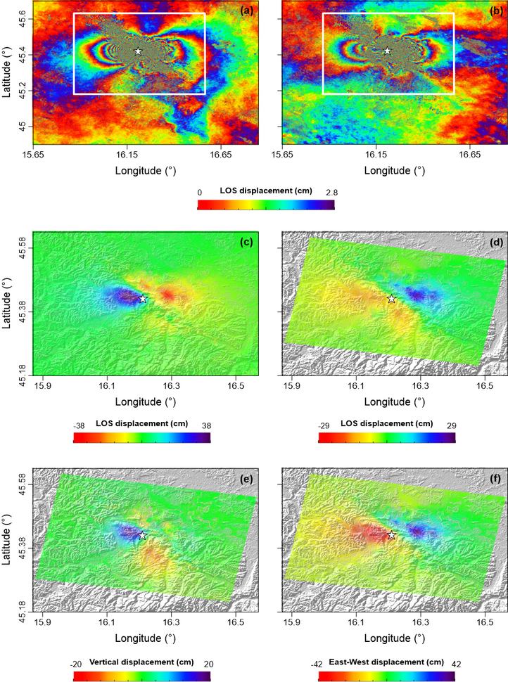
Figure 1. a) Sentinel-1 interferogram relevant to the 18122020-30122020 ascending pair (Track 146). b) Sentinel-1 interferogram relevant to the 23122020-04012021 descending pair (Track 124). The white rectangle represents the area shown in the following panels. c) Line-of-sight (LOS) displacement map computed from the Sentinel-1 interferogram of Figure 1a. d) LOS displacement map computed from the Sentinel-1 interferogram of Figure 1b. (e) Vertical and (f) East-West ground displacements maps. The white star indicates the location of the Mw 6.4 earthquake epicenter occurred on 29 December 2020.
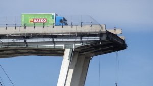
A recent analysis relating to the Morandi bridge shows the absence of deformations, before its collapse, in the results obtained from the satellite radar data of the Italian COSMO-SkyMed constellation. This evidence has been shown by a study conducted by a team of researchers from the CNR Institute for Electromagnetic Sensing of the Environment and published in Remote Sensing. The results are in contrast to previous findings published in the same journal.
On 14 August 2018, the bridge over the Polcevera stream on the A10 Genoa-Savona motorway, built on a design by the engineer Morandi in the 1960s, collapsed, resulting in the death of 43 people.
Following the tragic event, a team of researchers from the Institute for Electromagnetic Sensing of the Environment (IREA, Naples) of the National Research Council (CNR) conducted an in-depth study, based on the processing of satellite radar data, on possible pre-collapse movements associated with the area affected by the disastrous event, as part of the activities carried out as a Center of Competence for the Italian Civil Protection Department for the study of ground deformation phenomena through satellite measurements.
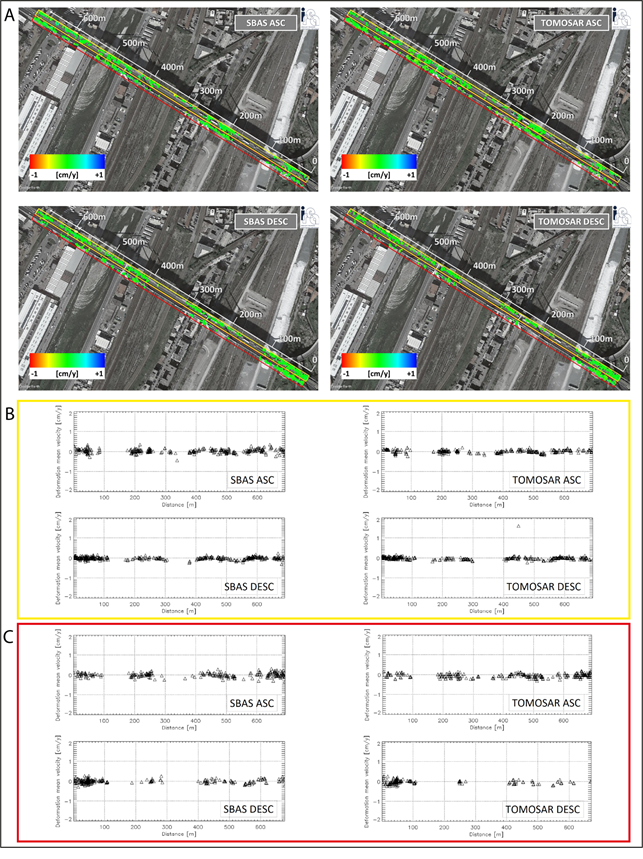
"The processing through advanced InSAR techniques of SAR data acquired by the COSMO-SkyMed constellation of the Italian Space Agency in the period immediately preceding the collapse (January 2011 - August 2018)" explains Riccardo Lanari, acting director of the CNR-IREA, "allowed us to generate deformation time series relating to the viaduct area which revealed the absence of significant surface movements precursors of the collapse of the bridge."
"The characteristics of these sensors, particularly the very high spatial resolution (a few m) and the very short wavelength (about 3 cm)" adds Diego Reale, an IREA researcher participating in the team, "made it possible to carry out a detailed analysis of the deformations relating to a complex infrastructure such as the Morandi bridge, in terms of density of measurement points and the ability to monitor the behavior of the entire structure, with millimeter accuracy."
"The products of the interferometric processing obtained using two independent and alternative approaches, such as the Small BAseline Subset (SBAS) technique and the SAR Tomography technique, showed a significant consistency and similarity between them, in terms of both spatial coverage and extent of measured deformation ”underlines Manuela Bonano, another IREA researcher member of the team, "confirming the substantial absence of superficial movements that were precursors of the collapse of the Morandi bridge."
The results obtained were presented in the work entitled “Comment on “Pre-Collapse Space Geodetic Observations of Critical Infrastructure: The Morandi Bridge, Genoa, Italy”, by Milillo et al. (2019)”, published in the same scientific journal Remote Sensing in December 2020.
Cover photo: LaPresse
 Maria Brovelli, Full Professor of Politecnico di Milano and Associate Member of IREA, has been elected Chair of the UN-GGIM Academic Network, an outstanding expert panel of United Nations focusing on topics and challenges of geospatial information (GI).
UN-GGIM (the Bureau of the United Nations Global Geospatial Information Management) addresses global issues about the exploitation of GI in the development agendas, supports policy in managing such information, and promotes its use to address key global challenges. In order to meet its objectives, UN-GGIM is assisted by the Network of academic experts that is going to be chaired by Professor Brovelli, whose main functions are:
• To provide academic counsel and guidance to UN-GGIM concerning strategic knowledge, research, education and training and to serve as a strategic academic arm for UN-GGIM and its related organizations and affiliated members in achieving their visions and goals;
• To provide a forum for coordination and dialogue among academics and researchers from the GI management community with a view to advance activities related to the administration, management, and use of GI, and to identify and respond to challenges and opportunities in which UN-GGIM and related members can achieve their visions;
• To provide a platform, so that the needs of member countries for GI data, technology, training and education, and the information of the capacities of academic network members are shared;
• To undertake work that is able to contribute to the Sustainable Development Goals of the UN (SDG) and other areas as appropriate including, access to land, property rights, ownership, land degradation, rapid urbanization, and climate change, in coordination with other expert entities.
Governance of the Academic Network is sketched in the Figure.The Chair and the Deputy Chair make executive decisions regarding network management, coordination and membership application requirement issues.
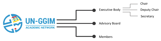
IREA is one out of three Italian members of the UN-GGIM Academic Network, together with Politecnico di Milano and University “La Sapienza” in Rome.
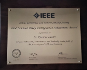
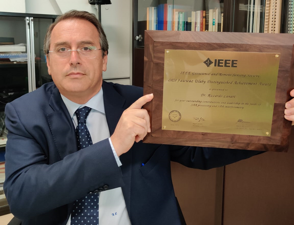 On Monday, 28 September, Riccardo Lanari - acting director of the Institute for Electromagnetic Sensing of the Environment (IREA) of the Italian National Research Council - received the IEEE GRSS Fawwaz Ulaby Distinguished Achievement Award 2020. The prestigious prize is conferred annually to recognize the individual who has made significant technical contributions within the technical scope of the Geoscience and Remote Sensing Society (GRSS) of the Institute of Electrical and Electronics Engineers (IEEE). These are the theory, concepts, and techniques of science and engineering as they apply to the remote sensing of the earth, oceans, atmosphere, and space, as well as the processing, interpretation, and dissemination of this information.
In particular, Riccardo Lanari distinguished himself "for the outstanding contributions and leadership in the fields of SAR processing and SAR interferometry”, as stated in the motivation of his award.
During the virtual ceremony to recognize the major awards, the President of the IEEE Geoscience and Remote Sensing Society said: "Riccardo Lanari has carried out thirty years of research activity in remote sensing, particularly on spaceborne synthetic aperture radar and SAR interferometry. He has given a key contribution to the development of the well-known Small BAseline Subset technique, which is today a reference method for interferometric SAR processing".
Riccardo Lanari, as was also mentioned during the award ceremony, is an IEEE fellow, a distinction reserved for select IEEE members who have distinguished themselves for extraordinary results, of significant impact for society, and who have contributed to progress in the field of engineering, science, and technology. He is also a recipient of the Christiaan Huygens Medal of the European Geosciences Union for significant progress in the area of Geosciences, instrumentation, and data systems.
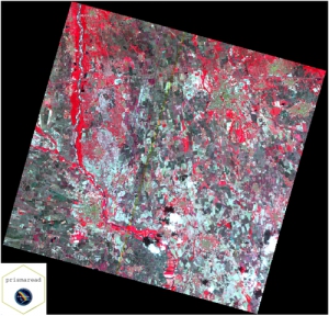
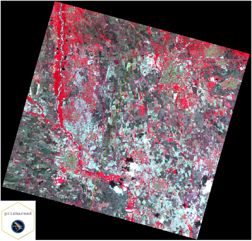 prismaread is an open source software package developed in "R" language by the Institute for Remote Sensing of Environment (IREA) of the National Research Council of Italy with the aim of facilitating access to the data acquired by the innovative PRISMA hyperspectral sensor, recently launched by the Italian Space Agency (ASI).
The new software package allows to access the hyperspectral data (and the corresponding accessory data) provided by ASI in HDF format and convert them into formats more easily usable for subsequent geospatial operations on raster data (ENVI, GeoTiff). It also allows to automatically calculate different spectral indices starting from the reflectance data, and to easily and quickly extract data on regions of interest and calculate the corresponding statistics.
The package is released under the GPL-3 open source license, and can be installed from the github repository at https://github.com/lbusett/prismaread/
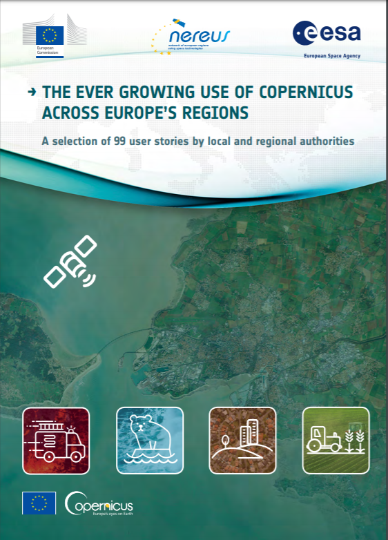 Under ESA flagship, the Project Copernicus4Regions has collected 99 user stories, titled “Ever Growing Use of Copernicus across Europe’s Regions”. They describe from a user perspective how regional public administrations in Europe have used data and information from the Copernicus Programme to face their challenges, and show benefits to citizens’ lives. The printed collection of sheets is available at the link
NEREUS, the Network of European regions dealing with space, after encouraging story collection with ESA, has now created a Search Engine (Copernicus4Regions Search Engine) to let public express queries choosing among the following parameters:
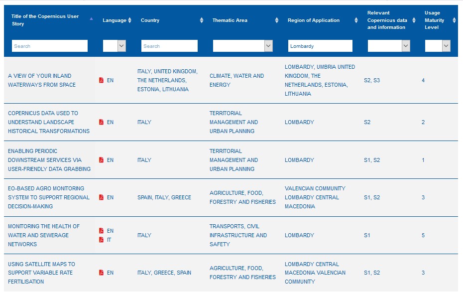
Researchers in IREA have provided some stories, in the thematic areas of Agriculture, Water, Civil Protection, with a focus on Lombardy and Campania Regions. In these application domains IREA research in remote sensing has a long-standing background and tradition, generating products with an advanced operational level, well appreciated by end users.
Copernicus4Regions Search Engine offers a friendly way to explore and outreach Copernicus benefits at regional scale, which are still unknown also to policy and decision makers, who are poorly aware of the effective downstream usage of Copernicus Programme. It is hosted in NEREUS platform and aims at helping the general audience as well as policymakers, experts, and researchers to explore the use case of their interest in one of the most spoken languages of the Network: Dutch, English, French, German, Italian, Portuguese, Spanish.
For further information, download the Call for Papers below
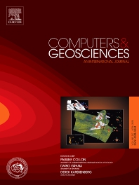 sen2r is an R package developed by the Institute of Remote Sensing of Environment (IREA) of the Italian National Research Council, with the aim to simplify and speed up several steps commonly needed to process Sentinel-2 data. Recently, an important recognition to the worth and usefulness of this tool came from the ISI journal Computers & Geosciences, publishing the scientific paper “sen2r”: An R toolbox for automatically downloading and preprocessing Sentinel-2 satellite data.
Up to the 14th of May 2020, it is possible to get free access to the manuscript at this link: https://authors.elsevier.com/a/1ao0SMMTPaksz.
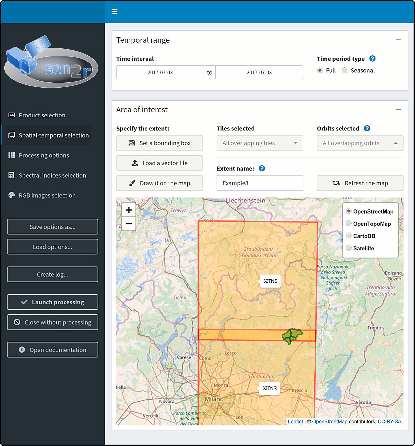 The paper provides an overview of the functionalities of the package: the steps performed by a standard processing chain are described, from the search and download of the available Sentinel-2 products over an area of interest and in a specific time window, to the actual preprocessing operations (clipping, reshaping and reprojecting, masking clouds, computing spectral indices and RGB images), to the description of the package operation through graphical user interface or command line instructions. Further details can be found at this link.
Last section of the manuscript shows a real sen2r use case as Service-Oriented Architecture backend, implemented in the framework of the SATURNO project, devoted to demonstrate a precision farming service infrastructure. This example illustrates how the package can be used, by defining and scheduling a custom processing chain, to provide added value information to end-users on the project geoportal.
sen2r is released with license GNU GPL-3, so it can be freely accessed and modified by users. The complete reference to the article, here reported, is to be used in scientific works that exploit the package:
L. Ranghetti, M. Boschetti, F. Nutini, L. Busetto (2020). “sen2r: An R toolbox for automatically downloading and preprocessing Sentinel-2 satellite data”. Computers & Geosciences, 139, 104473. DOI: 10.1016/j.cageo.2020. 104473, URL: http://sen2r.ranghetti.info.