
Maria Consiglia Rasulo

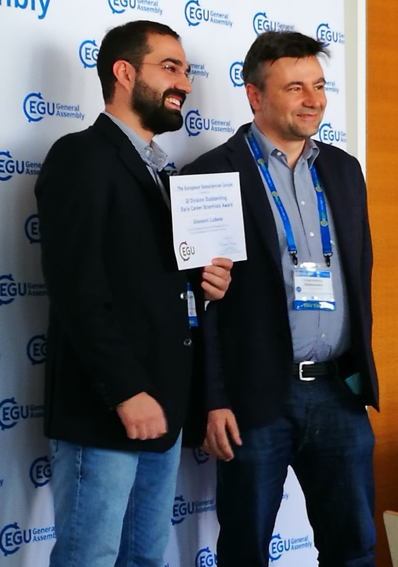
During the 2018 General Assembly of the EGU (European Geosciences Union), the largest and most important European event in the field of geosciences, held in Vienna from 8 to 13 April, Giovanni Ludeno, a temporary Researcher at IREA in Naples, received the "Division Outstanding Early Career Scientists Award", the prize that recognises scientific achievements in the field covered by the related division made by an early career scientist, in the field of Geosciences Instrumentation and Data Systems.
Ludeno’s research activity – we read in the explanatory statement to the award - highlights his capacity to significantly contribute to the methodological advances in the challenging scientific field of radar data processing for environmental monitoring. He is a worthy recipient of this award.
Giovanni Ludeno received his PhD degree in electronic and computer engineering at the Industrial and Information Engineering Department of the Second University of Naples, Italy, in 2015. Since November 2011, he is based at the Institute for Electromagnetic Sensing of the Environment (IREA) of the National Research Council of Italy.
His area of expertise regards the field of the applied electromagnetics, with a focus on the development of inversion methodologies for radar data processing. He has been mostly involved in the development and assessment of innovative strategies for the estimation of sea state parameters, such as surface currents and bathymetry, from high resolution marine X-band radar data. These methodologies have been applied in operative scenarios, such as the control of sea state parameters during the removal of the Costa Concordia ship wreck at the Isola del Giglio.
Now, he is also working in the field of inverse electromagnetic scattering for radar data processing, in subsoil investigations from ground-based platforms and from drones. Another of his fields of research regards the use of terahertz waves for material characterisation in several fields ranging from vegetation monitoring to archaeology.
He has participated in several European and Italian research projects, among which the flagship initiative ‘RITMARE: the Italian research for the sea’, PONHABITAT (HArBour traffIc opTimizAtion sysTem), and the H2020 project HEritage Resilience Against CLimate Events on Site (HERACLES).
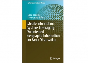
In January 2018, the book “Mobile Information Systems Leveraging Volunteered Geographic Information for Earth Observation”, has been published by Spinger, with editors Gloria Bordogna and Paola Carrara Researchers at IREA. It reports on cutting-edge mobile technologies used to acquire, analyze and manage volunteered geographic information (VGI), outlining new methods and tools to help overcome the main drawbacks of using VGI in Earth observation. It also discusses relevant case studies and addresses practical issues.
The volume includes papers by IREA authors (“Can VGI and Mobile Apps Support Long-Term Ecological Research? A Test in Remote Areas of the Alps”, Criscuolo, Laura et al., “VGI Imperfection in Citizen Science Projects and Its Representation and Retrieval Based on Fuzzy Ontologies and Level-Based Approximate Reasoning”, Bordogna, Gloria et al.) and one paper by Professor Maria Brovelli, IREA associate, et al. (“Mapping Parties at FOSS4G Europe: Fun, Outcomes and Lessons Learned”).
The book is divided into three parts, the first of which presents case studies on the implementation of VGI for Earth observation, discusses the characteristics of volunteers’ engagement in relation with their expertise and motivation, analyzes the tasks they are called upon to perform, and examines the available tools for developing VGI. In turn, the second part introduces readers to essential methods, techniques and algorithms used to develop mobile information systems based on VGI for distinct Earth observation tasks, while the last part focuses on the drawbacks and limitations of VGI with regard to the above-mentioned tasks and proposes innovative methods and techniques to help overcome them.
Given its breadth of coverage, the book offers a comprehensive, practice-oriented reference guide for researchers and practitioners in the field of geo-information management.

![]()
The International Journal of Geo-Information (IJGI) - ISSN 2220-9964, 2016, Impact Factor 1.502 - is the open access journal of the International Society for Photogrammetry and Remote Sensing (ISPRS) and is published monthly online by MDPI. IJGI provides an advanced forum for geographical information science. The scope of the journal covers all aspects of geographical information science, as well as relevant developments in other disciplines of remote sensing, photogrammetry, computer science and geography.
This Special Issue, whose Guest Editor is Gloria Bordogna Senior Researcher at Irea in Milan, is dedicated to exploring current experiences and trends with regards to the conceptual, methodological, and technological approaches defined and used in citizen science projects for processing and analyzing geoinformation, and of the social aspects related with their application.
We call for original papers from researchers worldwide, both in geoinformatic communities and citizen science associations and projects.
Further details can be found at this link
The submission Deadline is 31 March 2018.

The EU Education, Audiovisual and Culture Executive Agency (EACEA) has approved the project EO4GEO- Towards and innovative strategy for skills development and capacity building in the space geo-information sector supporting Copernicus user uptake.
EO4GEO is an Erasmus+ Sector Skills Alliance gathering 26 partners (and initially 22 associated partners, looking forward to new adhesions) from 16 countries from academia, private and public sector active in the education/training and space/geospatial sectors. It is coordinated by the Association GISIG and will run over four years, starting from 1st January 2018.
EO4GEO aims to help bridging the skills gap between supply and demand of education and training in the space/geospatial sector by reinforcing the existing ecosystem and fostering the uptake and integration of space/geospatial data and services in end-user applications. EO4GEO will work in an multi- and interdisciplinary way and apply innovative solutions for its education and training actions including: case based and collaborative learning scenarios; learning-while-doing in a living lab environment; on-the-job training; the co-creation of knowledge, skills and competencies; etc.
The 2 full days - that will be held at the CNR headquarters in Milan, Via Alfonso Corti 12 (Expo hall) - are the start of the activities involving the 26 project Partners and the Officiers of the European Commission Erasmus+ The schedule for the next 4 years will be presented with definition of the immediate activities of the first year. The 10 Work Pakages will be discussed and analysed and duties defined for each Partner. IREA-CNR is coordinator of the task 6.4 in WP 4: - Developing a long-term Action Plan (Dissemination and Expoitation) - Task 6.4 - Defining the long-term roll-out and maintenance plan'., and will contribute in several other WPs.
 Pasquale Imperatore and Romeo Bernini, researchers at the Institute for Electromagnetic Sensing of the Environment (IREA), are among the editors of the Special Issue "In Situ and Remote Sensors toward Integrated Earth Sensing” of Journal of Sensors.
The special issue is dedicated to recent advances, developments and applications in the field of Earth Sensing, including in-situ measurements and remote observations. A particular emphasis is placed on innovative integrated strategies for the analysis and exploitation of multisource data, towards characterization, interpretation and understanding of the physical, chemical and biological processes taking place on our planet.
Information on paper submission are available at the following URL:
Paper Submissions deadline: June 1, 2018.
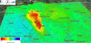
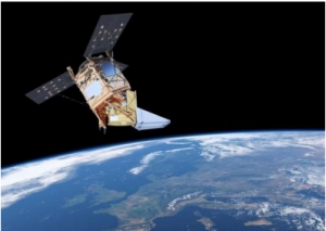
By exploiting the data of the Japanese satellite ALOS 2, obtained through scientific projects, a team of CNR and INGV researchers (coordinated by Riccardo Lanari, director of CNR-IREA, and by Stefano Salvi, technologist manager of INGV), measured with high precision the permanent ground displacements occurred during the earthquake, using the Differential Interferometry technique. This technique allows detecting deformations of the ground surface with centimeter accuracy by comparing radar images acquired before the event with those after the earthquake.
In particular, a ground subsidence with the shape of a "spoon" has been pointed out, which extends for about 20 km northwards and has a maximum value of about 20 centimeters at the Accumoli area.

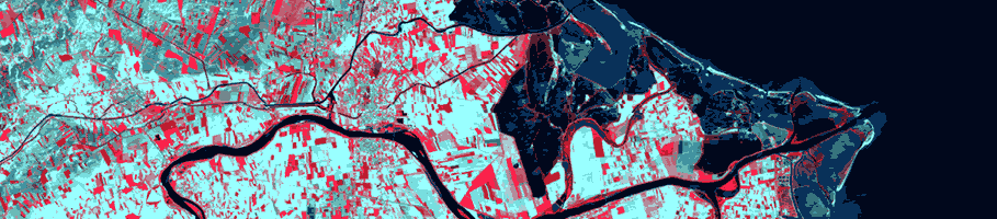
Deformation map obtained by elaborating, with the differential interferometry technique, the radar images of the satellite ALOS 2 acquired on 09/09/2015 (pre-event) and 24/08/2016 (post-event); the red area highlights the area affected by subsidence due to the seismic events, which reaches approximately 20 centimeters at Accumoli.
The ground displacement map was then used to develop the physical-mathematical models of the fault that originated the earthquake. Faults can be visualized as fracture planes along which two blocks of the Earth's crust are sliding: when the movement is very rapid an earthquake is generated. The fault that originated the Amatrice earthquake lies a few miles deep in the area between Amatrice and Norcia, under Accumuli. It is a 25 km long fracture plan that drifts southwest (towards Rieti) with a tilt of 50°. This plan corresponds to a fault already known by surface geological studies. A detailed knowledge of the location and characteristics of seismic sources is a key element for emergency management and is also important for the development of more reliable seismic hazard maps.
It is worth noting that obtaining in a short time a synoptic picture of ground deformations and displacements caused by an earthquake in the epicenter area is one of the objectives of the Civil Protection Department during a seismic emergency. In this specific case, the obtained outcomes are the result of the long and consolidated collaboration promoted by the Department among its Competence Centers - in this case, CNR-IREA and INGV. Based on their expertise, these centers support the DPC in the use of satellite data and information and their integration with in situ data. This activity has enabled the development of products, methods, and procedures that have improved the capabilities of the national alert and emergency response system. The results of this first interferometric monitoring are available for the entire National Civil Protection System through the Civil Protection Department, which is involved in the coordination of emergency management.
Download the file to see the deformation map in Google Earth
The study of the ground deformations and seismic sources related to the events of 24 August 2016 is going on. Thie activity is coordinated by the Department of Civil Protection (DPC) and is carried out by a team of researchers from the National Research Council (Institute for Electromagnetic Sensing of the Environment, CNR-IREA of Naples) and the National Institute of Geophysics and Vulcanology (INGV), centers of competence in satellite radar data processing and seismology, respectively, with the support of the Italian Space Agency (ASI).
After the first products obtained by using the radar data of the Japanese satellite ALOS 2, the analysis has also been enriched by the results of radar image processing obtained most recently by sensors (operating in C-band) of the Sentinel-1 constellation of the European Copernicus program and those (operating in X-band) of the Italian constellation COSMO-SkyMed developed by the Italian Space Agency in co-operation with the Ministry of Defense. In particular, applying the Differential SAR Interferometry technique to the joint use of Sentinel-1A and Sentinel-1B images acquired by ascending (South-North) and descending (North-South) orbits, it was possible to estimate the ground displacements along the two lines of sight of the radars, and from these, to extract the vertical and east-west components of deformations (Figure 1). The obtained results confirm the ground subsidence with the characteristic shape of a "spoon" that extends for about 20 km northwards, already observed from the analysis of ALOS 2 data, with a deformation of about 20 cm located at the area of Accumoli. Note also that the East-West component concerns an area larger than the vertical one (about 20 x 25 km2); it is characterized by the presence of four alternating displacement areas (blue towards the west and red toward the east, as shown in Figure 1), with maximum deformation values of about 16 cm westward.

Figure 1. At the top are the two co-seismic deformation maps (in the radar view lines) obtained from ascending and descending orbits, with the Differential SAR Interferometry technique, starting from the Sentinel-1A and 1B radar data acquired on 15/08/2016 and 21/08/2016 (pre-event images) and 27/08/2016 (post-event images). Below are shown the maps of the vertical and east-west components of the ground displacement, obtained by jointly using ascending (South-North) and descending (North-South) passages. The blue line represents the trace on the ground of the fault.
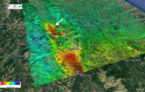
In addition to Sentinel-1 data, CNR and INGV researchers benefited from the radar acquisitions of the Italian constellation COSMO-SkyMed X-band sensors. It is emphasized that, thanks to the high spatial resolutions of this system, it is possible to obtain information on the ground deformation pattern with a great spatial detail. In this regard, Figure 2 shows the map of co-seismic deformation, generated from radar data acquired on descending orbits on 20/08/2016 (pre-event) and 28/08/2016 (post-event), relating to the zone stretching from Tufo and Pescara del Tronto to the area of Castelluccio. Note that the best spatial resolution also allows identifying localized deformation effects (landslides, reactivated faults) such as, for example, the ground displacement (identified by the arrow in Figure 2) relating to an area extending approximately 800 x 600m on the side of Mount Vettore, probably linked to a slope instability. The information obtained is particularly relevant for the analysis of geological and geophysical processes underway and for the study of the fault behaviour through the development of advanced physical-mathematical models.


Wildfires records for 2017 summer season indicate that Italy, in Europe, had the highest number of fire events, while in terms of forest area burned, Portugal was the most affected country, where sadly this year’s fires have caused the loss of 40 people.
In the frame of the conference "Protecting the forests from the fires: proposals and actions for the preservation and recovery of the territory. Case Study: Vesuvius "(Naples, October 16, 2017), organized by the General Command of Carabinieri, Dr. Bruno Petrucci of the Directorate General for the Protection of Nature and Sea (DGPNM) of the Ministry of the Environment and Territorial Protection and the Sea (MATTM) held an invited presentation with the contribution of the work done by CNR-IREA researchers.
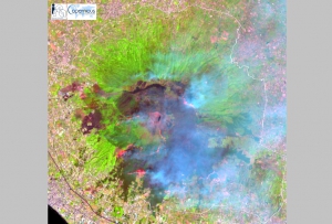
In particular, CNR-IREA has been responsible for processing Copernicus Sentinel-2 satellite imagery to detect areas affected by wildfires that hit the Vesuvius National Park during the 2017 summer season. Images of Figure 2 show the effects of the wildfire on the vegetation cover within the National Park area.

Figure 2 – Vesuvius National Park: comparison between images acquired by ESA Sentinel 2A satellite (natural colors RGB: 432 red, green, blue with 10 m ground spatial resolution) before and after the major fire events of summer 2017. (a) data acquired on May 18, 2017; (b) data acquired on August 26, 2017. Sentinel 2 data are Copernicus copyright (2017). National Park Perimeter (DGPNM / MATTM).
Figure 3 shows maps of fire affected areas produced by processing Sentinel 2A and Sentinel 2B satellite data acquired by ESA. Each color represents the date when the area was first detected as burned. The automatic mapping algorithm is based on the fuzzy integration of spectral indices, e.g. binary combinations of S2 spectral bands (Stroppiana et al., 2012; http://dx.doi.org/10.1016/j.isprsjprs.2012.03.001). The algorithm was applied exclusively to "natural vegetation areas" extracted from the Corine Land Cover map (2012) and within the boundaries of the Vesuvius National Park (DGPNM / MATTM).
IREA researchers are committed to developing new methodologies for the integrated use of optical and SAR data made available by the ESA Sentinel constellations for better characterization of the effects of wildfires on forested areas.

Figure 3 - Vesuvius National Park: Burned area maps derived from ESA Sentinel 2A and 2B images acquired during 2017 summer season. Sentinel 2 data are Copernicus copyright (2017). National Park Perimeter (DGPNM / MATTM).
The study of The Earth's deformations and seismic sources continues, focusing on the events of October 26. This activity is coordinated by the Department of Civil Protection (DPC) and is carried out by a team of researchers from the Institute for Electromagnetic Sensing of the Environment of the National Research Council (CNR-IREA of Naples) and the National Institute of Geophysics and Vulcanology (INGV), centers of competence in satellite radar data processing and seismology, with the support of the Italian Space Agency (ASI).
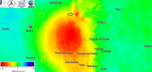
"Using the data from the Japanese satellite ALOS 2, the team of CNR-IREA and INGV researchers measured also on this occasion and with high precision, the permanent ground movements originated during the earthquake by using differential interferometry," explains the director of CNR-IREA Riccardo Lanari. "In this case, the bandwidth used (L band) from the radar operating on board the ALOS 2 satellite allowed us to detect the ground deformations despite the affected area was particularly covered by vegetation. These deformations occur about 8 kilometers further north than those caused by Amatrice's earthquake on August 24, and characterize an area that extends about 20 km northward and have a maximum subsidence of about 18 cm (corresponding to 22 centimeters away, compared to the radar line of sight) at the Vallestretta area".

“Ground movements, along with other geological and seismological data, are now undergoing analysis to elaborate physical-mathematical models through which it will be possible to identify the fault responsible for the earthquake and characterize its profound activity. The first results seem to indicate that the fault activated on October 26 is part of the same geological structure that caused the earthquake of Amatrice. The fault plane, therefore, is inclined to the west about 50 °, lies between 10 and 3 kilometers in depth and does not reach the surface," explains Stefano Salvi of INGV. "Starting from the Colfiorito sequence in 1997, radar satellite data have been used many times in Italy to detect seismic and volcanic sources, thanks also to the techniques developed by CNR-IREA researchers, who are now at the international forefront."
The purpose of the Civil Protection Department, during a seismic emergency, is to quickly obtain a picture of ground deformations and displacements caused by the earthquake in the epicenter area. The CNR-IREA and INGV Competence Centers, thanks to their specific skills, support the Department in the use of satellite data and information and their integration with in situ data. This collaboration enables the development of products, methods, and procedures that improve the national emergency response system and are available to the entire National Civil Protection Service.
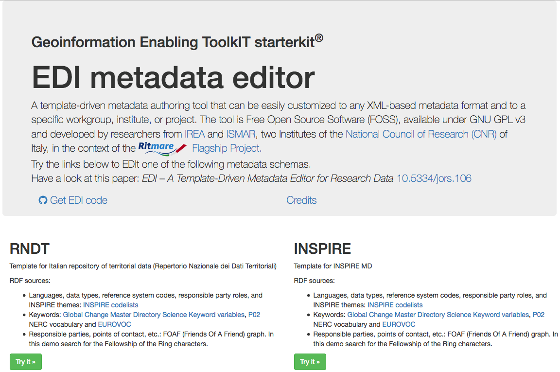 The National Directory of Territorial Data has reported EDI software as a new tool for all Public Administrations committed to enhancing their territorial data heritage.
EDI, developed by IREA-CNR under the RITMARE project, responds in particular to the challenges of quality and coherence of geographic information by giving a variety of modules that guide users to creating metadata in a simple and effective way.
The EDI editor is currently available online and allows a standard compilation according to Italian law (RNDT), but also complying with European and international specifications (INSPIRE and SensorML), thus meeting the needs of different users. Groups, projects or research institutes, but also technicians working in Public Administrations, can take advantage from the product by benefiting from some features that make data management less burdensome.
The software, licensed under Free Open Source (FOSS) GNU GPL v3, is fully customizable. Aspects that were recognized by EDI in the RNDT portal, today a public register of national territorial information certified and available precisely thanks to its metadata.
For more information and technical details of the instrument refer to the paper: Pavesi, F., A. Basoni, C. Fugazza, S. Menegon, A. Oggioni, M. Pepe, P. Tagliolato, and P. Carrara. “EDI – A Template-Driven Metadata Editor for Research Data.” Journal of Open Research Software - JORS 4 (October 25, 2016). doi: 10.5334/jors.106.
