
Maria Consiglia Rasulo
Publications in journals: 2010, 2011, 2012, 2013, 2014, 2015
-
Valente A, Sathyendranath S, Brotas V, Groom S, Grant M, Taberner M, Antoine D, Arnone R, Balch WM, Barker K, Barlow R, Belanger S, Berthon JF, Besiktepe S, Brando V, Canuti E, Chavez F, Claustre H, Crout R, Frouin R, Garcia-Soto C, Gibb SW, Gould R, Hooker S, Kahru M, Klein H, Kratzer S, Loisel H, McKee D, Mitchell BG, Moisan T, Muller-Karger F, O'Dowd L, Ondrusek M, Poulton AJ, Repecaud M, Smyth T, Sosik HM, Twardowski M, Voss K, Werdell J, Wernand M, Zibordi G, “A compilation of global bio-optical in situ data for ocean-colour satellite applications”, Earth System Science Data, Vol. 8 (1), pp 235-252.
-
Bevacqua MT, Scapaticci R, "A compressive sensing approach for 3d breast cancer microwave imaging with magnetic nanoparticles as contrast agent “, IEEE Transactions on Medical Imaging, Vol. 35 (2), pp 664-673.
-
De Novellis V, Castaldo R, Lollino P, Manunta M, Tizzani P, “Advanced three-dimensional finite element modeling of a slow landslide through the exploitation of DInSAR measurements and in situ surveys”, Remote Sensing, Vol. 8 (8), doi:10.3390/rs8080670.
-
Borgogno-Mondino E, Lessio A, Gomarasca MA, “A fast operative method for NDVI uncertainty estimation and its role in vegetation analysis”, European Journal of Remote Sensing, Vol 49, pp 137-156.
-
Minardo A, Bernini R, Zeni L, “Analysis of SNR penalty in Brillouin optical time-domain analysis sensors induced by laser source phase noise”, Journal of Optics, Vol. 18 (2), doi:10.1088/2040-8978/18/2/025601.
-
Pepe A, Solaro G, Calò F, Dema C, “A Minimum Acceleration Approach for the Retrieval of Multiplatform InSAR Deformation Time Series”, IEEE Journal of Selected Topics in Applied Earth Observations and Remote Sensing, Vol. 9 (8), pp 3883-3898.
-
Bellizzi G, “A New Formulation for the Radiation Operator: Application to the Fast Computation of the Singular Value Decomposition”, IEEE Transactions on Antennas and Propagation, Vol. 64 (8), pp 3478-3486.
-
Di Donato L, Palmeri R, Sorbello G, Isernia T, Crocco L, “A New Linear Distorted-Wave Inversion Method for Microwave Imaging via Virtual Experiments”, IEEE Transactions on Microwave Theory and Techniques, Vol 64 (8), pp 2478-2488.
-
Loperte A, Soldovieri F, Palombo A, Santini F, Lapenna V, “An integrated geophysical approach for water infiltration detection and characterization at Monte Cotugno rock-fill dam (southern Italy)”, Engineering Geology, Vol. 211, pp 162-170.
-
Punzo M, Lanciano C, Tarallo D, Bianco F, Cavuoto G, De Rosa R, Di Fiore V, Cianflone G, Dominici R, Iavarone M, Lirer F, Pelosi N, Giordano L, Ludeno G, Natale A, Marsella E, “Application of X-Band Wave Radar for Coastal Dynamic Analysis: Case Test of Bagnara Calabra (South Tyrrhenian Sea, Italy)”, Journal of Sensors, Volume 2016, 2016, doi:10.1155/2016/6236925.
-
Azar R, Villa P, Stroppiana D, Crema A, Boschetti M, Brivio PA, “Assessing in-season crop classification performance using satellite data: A test case in Northern Italy”, European Journal of Remote Sensing, Vol. 49, pp 361-380.
-
Zinno I, Mossucca L, Elefante S, De Luca C, Casola V, Terzo O, Casu F, Lanari R, “Cloud computing for earth surface deformation analysis via spaceborne radar imaging: A case study”, IEEE Transactions on Cloud Computing, Vol. 4 (1), pp 104-118.
-
Gennarelli G, Vivone G, Braca P, Soldovieri F, Amin MG, “Comparative Analysis of Two Approaches for Multipath Ghost Suppression in Radar Imaging”, IEEE Geoscience and Remote Sensing Letters, Vol 13 (9), pp 1226-1230.
-
Solaro G, De Novellis V, Castaldo R, De Luca C, Lanari R, Manunta M, Casu F, “Coseismic fault model of Mw 8.3 2015 Illapel earthquake (Chile) retrieved from multi-orbit Sentinel1-A DInSAR measurements”, Remote Sensing, Vol. 8 (4), doi:10.3390/rs8040323.
-
Gómez-Enri J, Scozzari A, Soldovieri F, Coca J, Vignudelli S, “Detection and characterization of ship targets using CryoSat-2 altimeter waveforms”, Remote Sensing, Vol. 8 (3), doi:10.3390/rs8030193.
-
Euillades LD, Euillades PA, Riveros NC, Masiokas MH, Ruiz L, Pitte P, Elefante S, Casu F, Balbarani S, “Detection of glaciers displacement time-series using SAR”, Remote Sensing of Environment, Vol. 184, pp 188-198.
-
Greco F, Currenti G, Palano M, Pepe A, Pepe S, "Evidence of a shallow persistent magmatic reservoir from joint inversion of gravity and ground deformation data: The 25-26 October 2013 Etna lava fountaining event”, Geophysical Research Letters, Vol. 43 (7), pp 3246-3253.
-
Soldovieri F, Gennarelli G, “Exploitation of ubiquitous Wi-Fi devices as building blocks for improvised motion detection systems”, Sensors, Vol. 16 (3), doi:10.3390/s16030307.
-
Bevacqua M, Crocco L, Donato LD, Isernia T, Palmeri R, “Exploiting sparsity and field conditioning in subsurface microwave imaging of nonweak buried targets”, Radio Science, Vol 51 (4), pp 301-310.
-
Diao F, Walter TR, Solaro G, Wang R, Bonano M, Manzo M, Ergintav S, Zheng Y, Xiong X, Lanari R, “Fault locking near Istanbul: Indication of earthquake potential from InSAR and GPS observations”, Geophysical Journal International, Vol. 205 (1), pp 490-498.
-
Casu F, Manconi A, “Four-dimensional surface evolution of active rifting from spaceborne SAR data”, Geosphere, Vol. 12 (3), pp 697-705.
-
Fiumara V, Fusco A, Iadarola G, Matta V, Pinto IM, “Free-Space Antenna Pattern Retrieval in Nonideal Reverberation Chambers”, IEEE Transactions on Electromagnetic Compatibility, Vol. 58 (3), pp 673-677.
-
Stevanović MN, Crocco L, Djordjević AR, Nehorai A, “Higher Order Sparse Microwave Imaging of PEC Scatterers”, IEEE Transactions on Antennas and Propagation, Vol. 64 (3), pp 988-997.
-
Minardo A, Coscetta A, Bernini R, Zeni L, “Heterodyne slope-assisted Brillouin optical time-domain analysis for dynamic strain measurements”, Journal of Optics, Vol. 18 (2), doi:10.1088/2040-8978/18/2/025601.
-
Romeo S, Sannino A, Scarfì MR, Massa R, Dangelo R, Zeni O, "Lack of effects on key cellular parameters of MRC-5 human lung fibroblasts exposed to 370 mT static magnetic field”, Scientific Reports, Vol. 6, doi:10.1038/srep19398.
-
Rana FM, Adamo M, Pasquariello G, De Carolis G, Morelli S, “LG-mod: A modified local gradient (LG) method to retrieve SAR sea surface wind directions in marine coastal areas”, Journal of Sensors, Vol. 2016, doi:10.1155/2016/9565208.
-
Catapano I, Affinito A, Guerriero L, Bisceglia B, Soldovieri F, “Majolica imaging with THz waves: preliminary results”, Applied Physics A: Materials Science and Processing, Vol. 122 (5), doi:10.1007/s00339-016-0055-2.
-
Giardino C, Bresciani M, Fava F, Matta E, Brando VE, Colombo R, “Mapping submerged habitats and mangroves of Lampi Island Marine National Park (Myanmar) from in situ and satellite observations”, Remote Sensing, Vol. 8 (1), doi:10.3390/rs8010002.
-
Busetto L, Ranghetti L, “MODIStsp: An R package for automatic preprocessing of MODIS Land Products time series”, Computers and Geosciences, Vol. 97, pp 40-48.
-
Campos-Taberner M, García-Haro FJ, Confalonieri R, Martínez B, Moreno Á, Sánchez-Ruiz S, Gilabert MA, Camacho F, Boschetti M, Busetto L, “Multitemporal monitoring of plant area index in the valencia rice district with PocketLAI”, Remote Sensing, Vol. 8 (3), doi:10.3390/rs8030202.
-
Bellizzi G, Bucci OM, Chirico G, “Numerical assessment of a criterion for the optimal choice of the operative conditions in magnetic nanoparticle hyperthermia on a realistic model of the human head”, International Journal of Hyperthermia, Vol. 32 (6), pp 688-703.
-
Bucci OM, Crocco L, Scapaticci R, Bellizzi G, “On the Design of Phased Arrays for Medical Applications”, Proceedings of the IEEE, Vol. 104 (3), pp 633-648.
-
Scifoni S, Bonano M, Marsella M, Sonnessa A, Tagliafierro V, Manunta M, Lanari R, Ojha C, Sciotti M, “On the joint exploitation of long-term DInSAR time series and geological information for the investigation of ground settlements in the town of Roma (Italy)”, Remote Sensing of Environment, Vol 182, pp 113-127.
-
Iero DAM, Crocco L, Isernia T, "On the Role and Choice of Source Polarization in Time-Reversal Focusing of Vector Fields”, IEEE Antennas and Wireless Propagation Letters, Vol. 15, pp 214-217.
-
Grimaldi IA, Testa G, Persichetti G, Loffredo F, Villani F, Bernini R, “Plasma functionalization procedure for antibody immobilization for SU-8 based sensor “, Biosensors and Bioelectronics, Vol. 86, pp 827-833.
-
Di Martino G, Iodice A, Natale A, Riccio D, “Polarimetric Two-Scale Two-Component Model for the Retrieval of Soil Moisture under Moderate Vegetation via L-Band SAR Data”, IEEE Transactions on Geoscience and Remote Sensing, Vol. 54 (4), pp 2470-2491.
-
Cherukuru N, Davies PL, Brando VE, Anstee JM, Baird ME, Clementson LA, Doblin MA, “Physical oceanographic processes influence bio-optical properties in the Tasman Sea”, Journal of Sea Research, Vol. 110, pp 1-7.
-
Gennarelli G, Ludeno G, Soldovieri F, “Real-time through-wall situation awareness using a microwave doppler radar sensor”, Remote Sensing, Vol. 8 (8), doi:10.3390/rs8080621.
-
Imperatore P, Pepe A, Lanari R, "Spaceborne Synthetic Aperture Radar Data Focusing on Multicore-Based Architectures”, IEEE Transactions on Geoscience and Remote Sensing, Vol. 54 (8), pp 4712-4731.
-
Perna S, Esposito C, Amaral T, Berardino P, Jackson G, Moreira J, Pauciullo A, Junior EV, Wimmer C, Lanari R, “The InSAeS4 airborne X-band interferometric SAR system: A first assessment on its imaging and topographic mapping capabilities”, Remote Sensing, Vol. 8 (1), doi:10.3390/rs8010040.
-
Brando VE, Lovell JL, King EA, Boadle D, Scott R, Schroeder T, “The potential of autonomous ship-borne hyperspectral radiometers for the validation of ocean color radiometry data”, Remote Sensing, Vol. 8 (2), doi:10.3390/rs8020150.
-
Gennarelli G, Solimene R, Soldovieri F, Amin MG, "Three-Dimensional Through-Wall Sensing of Moving Targets Using Passive Multistatic Radars”, IEEE Journal of Selected Topics in Applied Earth Observations and Remote Sensing, Vol. 9 (1), pp 141-148.
-
Arcaini P, Bordogna G, Ienco D, Sterlacchini S, “User-driven geo-temporal density-based exploration of periodic and not periodic events reported in social networks”, Information Sciences, Vol 340-341, pp 122-143.
-
Persichetti G, Bernini R, “Water monitoring by optofluidic Raman spectroscopy for in situ applications”, Talanta, Vol. 155, pp 145-152.
Naples is again among the 158 cities of the world in which the fifth International Space Apps Challenge, the big event sponsored by NASA, which will take place on April 23 and 24 at the Faculty of Engineering in Via Nuova Agnano 11.
Thanks to the organization supported by IREA, Department of Industrial Engineering, University of Naples Federico II, and US Consulate General for Southern Italy, many young people will have an opportunity to participate in an exciting global event and contribute their projects for one of the most prestigious institutions in the world such as NASA.
The International Space Apps Challenge is an event in which teams of students, technologists, scientists, designers, entrepreneurs, or simply enthusiasts of science and technology, work together and collaborate for 48 hours in various cities in the world to design innovative solutions to global challenges on Earth and in space.
The first Space Apps Challenge took place in 2012 among 25 cities around the world. Over the years, the event has involved a growing number of cities and participants. In 2015, it counted 13,918 participants in 133 cities globally, with 949 projects, and became the biggest hackathon ever made. For the first time, Napoli became part of this great event in 2015 and continues the active participation also for the current year.
Registration has already been started and it is absolutely free and open to everyone. At the end of the event, on Sunday afternoon, April 24, two teams will be selected as local winners. In addition, one People's Choice will be announced on the Space Apps Event. Among all the local winners, NASA will select the global winners in each of the five finalist categories: Best Use of Data, Best Use of Hardware, Best Mission Concept, Galactic Impact and Most Inspirational.
For information download the brochure:
For registration and detailed information follow the link: https://2016.spaceappschallenge.org/locations/napoli-italy
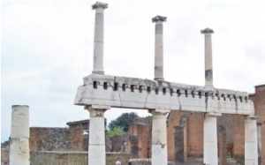

In the fascinating setting of Pompeii archaeological area, the school "Geophysics and Remote Sensing for Archaeology" will be held from 9 to 13 May 2016.
The course is organised by two Institutes of the National Research Council of Italy, i.e. CNR-IBAM and CNR-IREA, and Soprintendenza Speciale Beni Archeologici Pompei, Ercolano e Stabia.
The School aims at giving the opportunity to scholars, Ph.D. students, researchers and specialists in Geophysics, Remote Sensing and Archaeology to deepen their knowledge and expertise with geophysical and remote sensing techniques for archaeology and cultural heritage documentation and management. The school consists of lectures and on-field practical work.
For more information about contents and timing of courses, registration and Participation download the brochure:
![]()
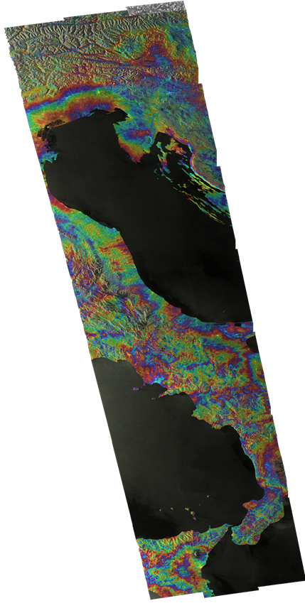
Continental scale mapping capabilities of Sentinel-1 sensor: the 12-days InSAR coherence over Europe
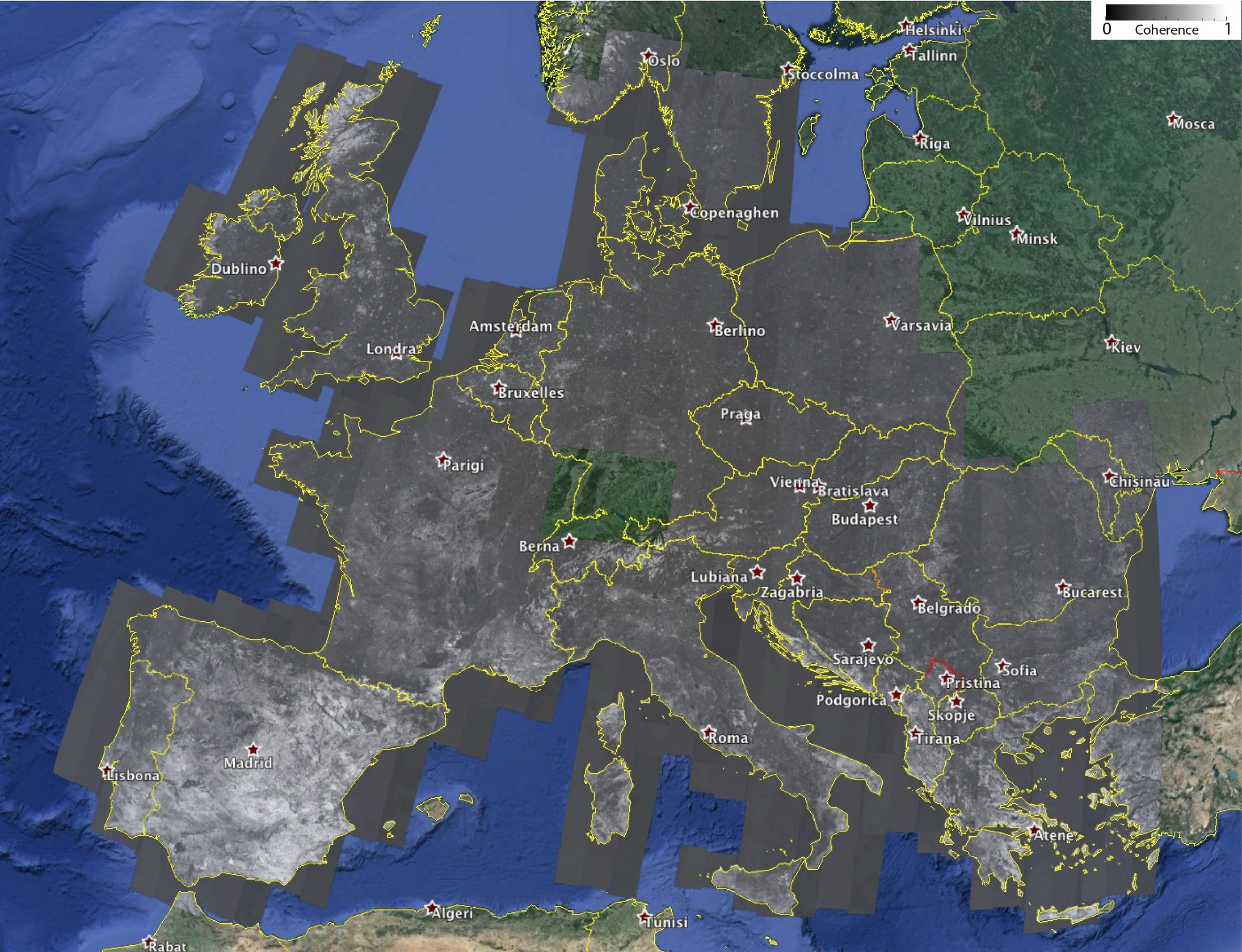 Sentinel-1 is the first satellite of the Copernicus program and is equipped with a Synthetic Aperture Radar (SAR) sensor that is able to provide day-night acquisitions nearly over the whole World. The Sentinel-1 operational mode on land is the so-called Interferometric Wide Swath (IWS), which guarantees the Earth’s global coverage with a revisit time of 12 days, thus making Sentinel-1 as a powerful system for surface displacement monitoring at global scale through Interferometric SAR (InSAR) technique.
In this context, scientists of IREA-CNR processed 380 Sentinel-1 imagery, acquired over Europe during the June-July 2015 period and coupled in 190 12-days interferometric pairs with 2 looks in azimuth and 10 in range, with the final aim to analyse the InSAR characteristics of the European Continent. Such a study permits to assess the Sentinel-1 InSAR performances as well as to have an idea of the expected InSAR measurements quality over the Europe. As a result, in Figure 1 the 12-days Interferometric Coherence map of almost the entire Europe is shown; note that white and black areas correspond to high (close to 1) and low (close to 0) coherence values, respectively.
“This work demonstrates the high capabilities of Sentinel-1 system for surface displacement detection at global scale”, states Francesco Casu, researcher at IREA-CNR, “and represents the first step towards the generation of continental scale Earth’s surface deformation maps and time series”.
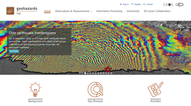
This study has been carried out by exploiting the automated and unsupervised IREA-CNR processing tools integrated within the Geohazards Exploitation Platform (GEP), an ESA initiative for fostering the creation of a novel and dynamic scientific environment where are at user disposal, at the same time and in the same place, data, computing facilities and processing tools.
“The GEP environment, that hosts the IREA-CNR InSAR tools freely accessible to the scientific community”, says Michele Manunta, researcher at IREA-CNR, “permits researchers to change the way they do science, opening new scenarios in terms of data access, processing capacity and result sharing, thus fostering the creation of knowledge”. Within the GEP, the main IREA-CNR task is to set-up an automated service for the systematic generation and update of SBAS-InSAR displacement time series originated from Sentinel-1 data.
This study, realized with the support of the ESA GEP, TEP-QW and G-POD projects, as well as of the Italian Department of the Civil Protection, paves the way for the implementation, in the near future, of new services and products addressed to the scientific community (as for instance the EPOS one), as well as to the National Departments of Civil Protection.
 In the frame of the next AGU 2015 Fall meeting IREA-CNR organized a training event on “Training on the SBAS-DInSAR web tool for Earth surface deformation analysis through the ESA Geohazard Exploitation Platform”.
The event originates in the context of space-borne geodetic techniques, and will focus on Differential Synthetic Aperture Radar Interferometry (DInSAR), which has already demonstrated its capability to measure surface displacements in different conditions and scenarios. In particular, the advanced DInSAR time series processing methods, as for instance the Small BAseline Subset (SBAS) one that allows studying both the spatial and temporal variability of the surface displacements, have proven to be particularly suitable in different contexts, as for natural hazards (volcanoes, earthquakes and landslides) and human-induced deformation (subsidence due to aquifer exploitation, mining operations, and building of large infrastructures).
Recently, the IREA-CNR implementation of the SBAS algorithm has been fully integrated (http://goo.gl/KE9Qna) within the ESA's Grid Processing on Demand (G-POD) environment, which is part of the Geohazards Thematic Exploitation Platform (GEP) of ESA. The GEP is an R&D activity on the ESA EO ground segment to demonstrate the benefit of new techniques for large scale processing of EO data. This encompasses both user driven on-demand processing as well as systematic processing, to address common information needs of the geohazards community as a whole. Accordingly, the GEP is sourced with data, computing resources and processing tools, including SBAS-DInSAR, relevant to the geohazard theme.
The integration of the SBAS-DInSAR algorithm within GEP resulted in a web-based tool freely available to the scientific community. This tool allows users to process, from their own laptops, the European SAR data archives (ERS, ENVISAT and Sentinel-1) for obtaining surface displacement maps and time series in a completely unsupervised way, without caring about data download and processing facility procurements.
More information about the training event at https://www.eventbrite.com
 During the "1st World Congress on Electroporation and Pulsed Electric Fields in Biology, Medicine and Food & Environmental Technologies", which was held in in Portoroz (Slovenia) from 5 to 10 September 2015, Dr. Stefania Romeo, a research fellow at IREA in Naples, received the second prize in the category Medicine and Biology of the Young Investigator Competition reserved to young researchers under 35.
The work presented, entitled "Electroporation of a bladder cancer cell line in presence of calcium: efficacy dependence on electric field strength and calcium concentration" (authors: Stefania Romeo, Emilie L. Hansen, Stine K. Frandsen, Julie Gehl), deals with the use of intense pulsed electric fields to facilitate the massive entry of calcium into the tumor cells so as to induce death. This technique is very promising in the field of cancer therapy, being the calcium nontoxic and cheaper than the commonly used drugs for electrochemotherapy.
The methodology was used for the first time by the group of Dr. Julie Gehl from the Department of Oncology at the University of Copenhagen, with whom Dr. Romeo worked in May 2014 in the framework of a short term scientific mission funded by COST TD1104 (European Network for the development of Electroporation-based Technologies and Treatments). During the period of co-operation an experimental work with subsequent analysis of data was done, to optimize some parameters of the technique (electric field intensity and concentration of calcium) in order to increase the efficiency of the treatment.
The results of this work have been published in the journal Plosone http://journals.plos.org/plosone/article?id=10.1371/journal.pone.0122973
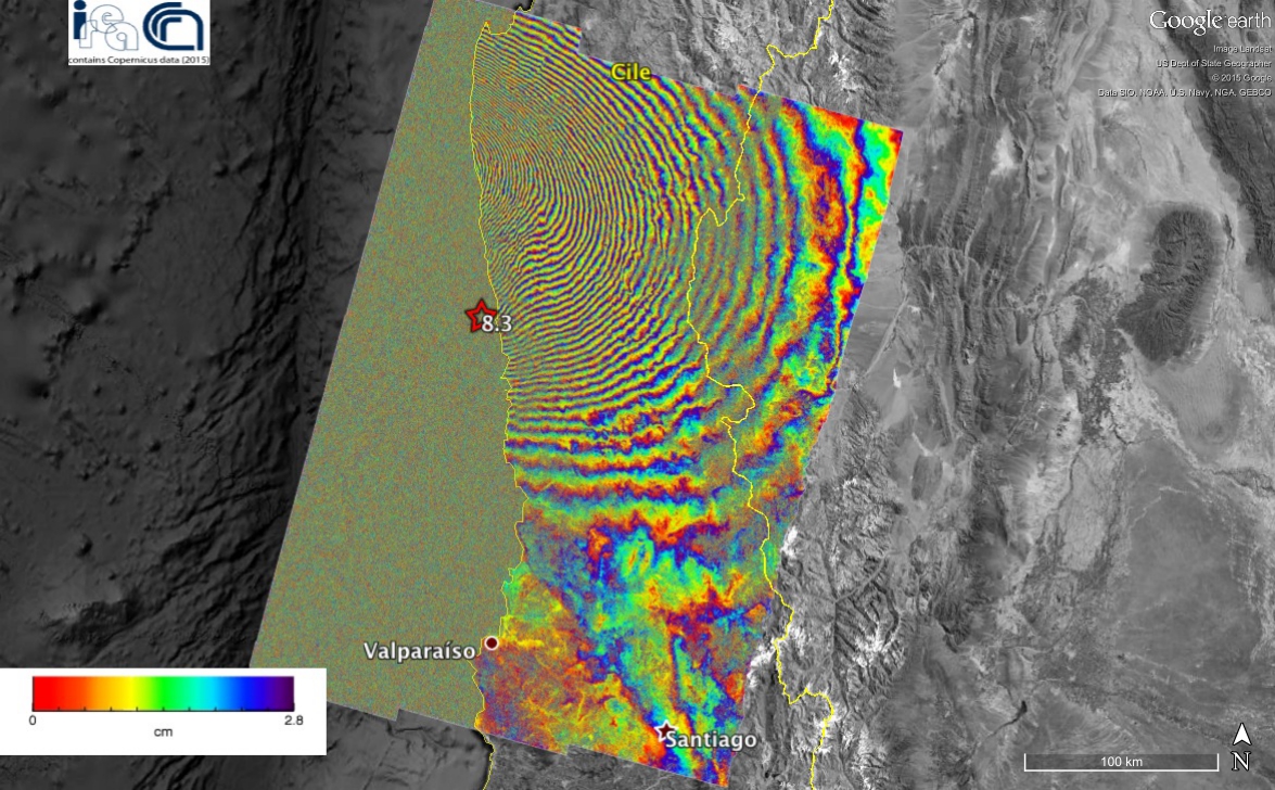 An earthquake of magnitude 8.3 struck the central region of Chile, 46 km west of the city of Illapel, at 22:54:33 (UTC) on September 16, 2015. The area is considered one of the regions at highest seismic risk in the world. The seismic activity in the region is caused by the convergence of the Nazca and South America plates with a relative movement between the two plates of about 74 mm / year (source: USGS).
The earthquake is the result of a movement along a reverse fault dipping eastward, having a length of approximately 250 km and a width of about 100 km.
Via differential radar interferometry, researchers at the Institute for Electromagnetic Sensing of the Environment have studied the field of surface deformation caused by the quake. In particular, they used the data acquired on July 31 and September 17, 2015 (immediately after the event) by the European satellite Sentinel-1A, that have made it possible to generate the displacement map (interferogram) shown in the figure. Each color band (fringe) indicates a ground shift of approximately 2.8 centimeters, with a maximum deformation of about 140 centimeters.
The activity has been conducted as part of the agreement between IREA-CNR and the Italian Department of Civil Protection (DCP), the TEP-QuickWin project of the European Space Agency (ESA) and the project "High Technological Infrastructure for Integrated Monitoring of Climate and Environment" (I-AMICA) funded by the Italian Ministry of Education, University and Research as part of the National Operational Programme (PON). The presented results contain Copernicus data 2015.
A new technique can calculate, through Satellites and GPS data, how the deep magma goes up inside the ground of Campi Flegrei, creating even millimeter deformations of the Earth's surface. A mechanism probably common to other calderas (Yellowstone in the US and Rabaul in Papua New Guinea). The study, published in Scientific Reports, provides new monitoring systems useful to deal with possible future volcanic crises.
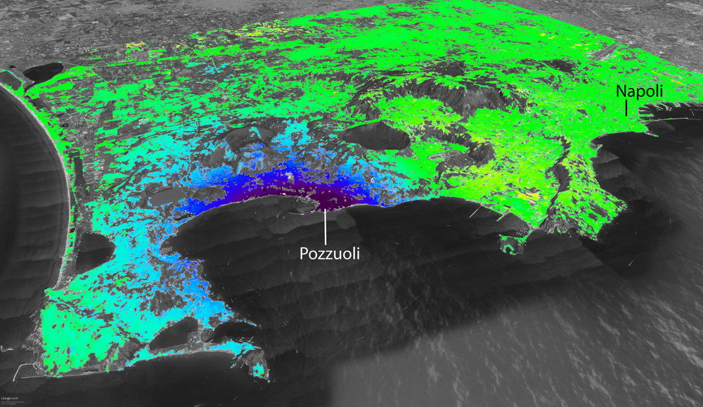
The data acquired from satellites and GPS receivers of the network of sensors placed in the Campi Flegrei area are used to monitor the Earth's surface deformations and to know, in real time, the trend of the ground uplift in the caldera. This is the new monitoring technique developed by a team of researchers from the Institute for Electromagnetic Sensing of the Environment of the National Research Council (CNR-IREA) and the Vesuvius Observatory of the National Institute of Geophysics at Volcanology (INGV- OV), in order to better understand the uplift phenomena occurred in recent years at Campi Flegrei. The study, which is part of the monitoring activities promoted by the Italian Department of Civil Protection (DPC) and those undertaken under the European project MED-SUV (MEDiterraneanSUpersite Volcanoes), was published in Scientific Reports.
"Thanks to the data acquired by the Cosmo-SkyMed satellites (launched by the Italian Space Agency since 2007), equipped with radar systems, and by GPS receivers of the INGV-OV geodetic surveillance network, composed by 14 sensors spread in the Campi Flegrei area", says Susi Pepe, researcher at CNR-IREA," it has been possible to study the deformations, even millimetric, of the Earth's surface and know the trend of the ground uplift in the caldera in correspondence to the receivers".
In the past millennia the Campi Flegrei caldera produced eruptions of gigantic dimensions: forty thousand years ago the Campanian ignimbrite and fifteen thousand years ago the Neapolitan Yellow Tuff, which made the superficial part of the volcano collapse for hundreds of meters, forming the current structure. "After the last eruption in 1538 that produced the Monte Nuovo crater", says Luca D'Auria, the researcher in charge of the Vesuvius Observatory monitoring room, "the ground of the Campi Flegrei began to sink slowly for centuries, untill around 1950, when the area started to raise. This phenomenon, known as bradyseism, showed all its violence between 1982 and 1985, the period when the ground raised almost 2 meters, with accompanying earthquakes, resulting in the evacuation of thousands of residents of the town of Pozzuoli. In 2005 the ground restarted to rise slowly and earthquakes, of low magnitude, reappeared."
Over the past 10 years, the ground has risen almost 30 cm., so much so that in December 2012, based on indications of the Commission Great Risk, the Civil Protection raised the alert level of Campi Flegrei from green (repose) to yellow (warning). "Regarding the origin of the flegrean bradyseism" continues D'Auria, "the scientific community agrees that between 1985 and 2012 the ground uplift was linked to the placing of hydrothermal fluids (water and gas) within the caldera rocks and the progressive heating of the latter. About the most recent episode, between 2012 and 2013, the phenomenon would instead be attributed to the rise of magma at shallow depth (approximately 3 km) that is injected into the subsurface rocks, forming a thin layer, known as the sill, a small "lake underground", with a radius of 2-3 km. The sill was already in the ground and it was probably active during the bradiseismic crises of the past decades when amount of magma, even ten times higher, arrived in this small shallow magma chamber."
The magma within the sill, however, can cool down quickly, thus making it less able to produce explosive eruptions. This mechanism, observed at Campi Flegrei, is probably common to other calderas (for example, Yellowstone in the US and Rabaul in Papua New Guinea) and may explain some behaviors apparently 'bizarre' observed in these volcanoes. "The predictions of volcanic eruptions in the calderas often presents greater difficulties than other volcanoes" adds D'Auria. "The lift and the intrusion of magma within the sill may, in fact, be the normal life cycle of the calderas."
The results of the study are of great importance for the interpretation of the data acquired by the new generations of satellites (like those of the constellation Sentinel of the European Program Copernicus, carried out by the European Space) and the innovative technologies of geophysical monitoring at Campi Flegrei. "These new monitoring systems, integrated with the new methods of analysis, may provide a useful tool to address possible, future volcanic crises at Campi Flegrei" says Susi Pepe at CNR.
Link to the article: www.nature.com/articles/srep13100
Researchers at the Institute for Electromagnetic Sensing of the Environment (IREA) have obtained a drastic improvement in mapping surface deformations thanks to data acquired by the year-old European satellite Sentinel-1A. The result, which opens new perspectives for earthquake and volcano monitoring, has been recently reported on the European Space Agency website.
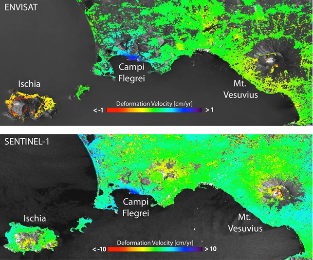
"Our study - said Riccardo Lanari, Director of IREA - clearly demonstrates that we can dramatically increase the spatial coverage of deformation maps, in terms of pixel density, in comparison to the results obtained with previous generations of SAR systems such as ERS and Envisat."
This is evident when comparing the mean deformation velocity maps generated from Sentinel-1A and Envisat data over Napoli Bay (Italy), where three main volcanic complexes – Mount Vesuvius, Campi Flegrei Caldera and Ischia island – are located. In particular, the Sentinel-1A maps clearly show the volcano’s ‘spreading effect’ at the summit of Mount Vesuvius, which was only partially visible with previous products from ERS and Envisat. Also evident is the improvement of the measurement density achieved over the Campi Flegrei Caldera, characterized by an ongoing uplift.
The result has been achieved thanks to the SBAS (Small BAseline Subset) technique developed by IREA researchers, which permits the generation of spatially dense and highly accurate mean deformation velocity maps.
Already worldwide used, this technique is getting a growing interest. This is evidenced, for instance, by the large use of a version of the SBAS technique implemented in the Grid Processing On Demand (GPOD) portal of the ESA Geohazards Exploitation Platform (GEP), which allows users to perform automatic and user-friendly advanced analysis of the Earth's surface deformations by using ERS and Envisat data, and, in a near future, also Sentinel-1 data.
“The possibility to access Sentinel-1 SAR data, with the large coverage and a free and open access data policy, opens new perspectives in civil protection scenarios,” noted Michele Manunta, a researcher of IREA. “For instance, we may already generate, in an operational context, interferograms of nearly the entire Italian territory.”
Surface deformation mapping will be further improved with the upcoming launch of Sentinel-1A’s sister satellite – Sentinel-1B – that will shorten the revisit time from 12 to six days.
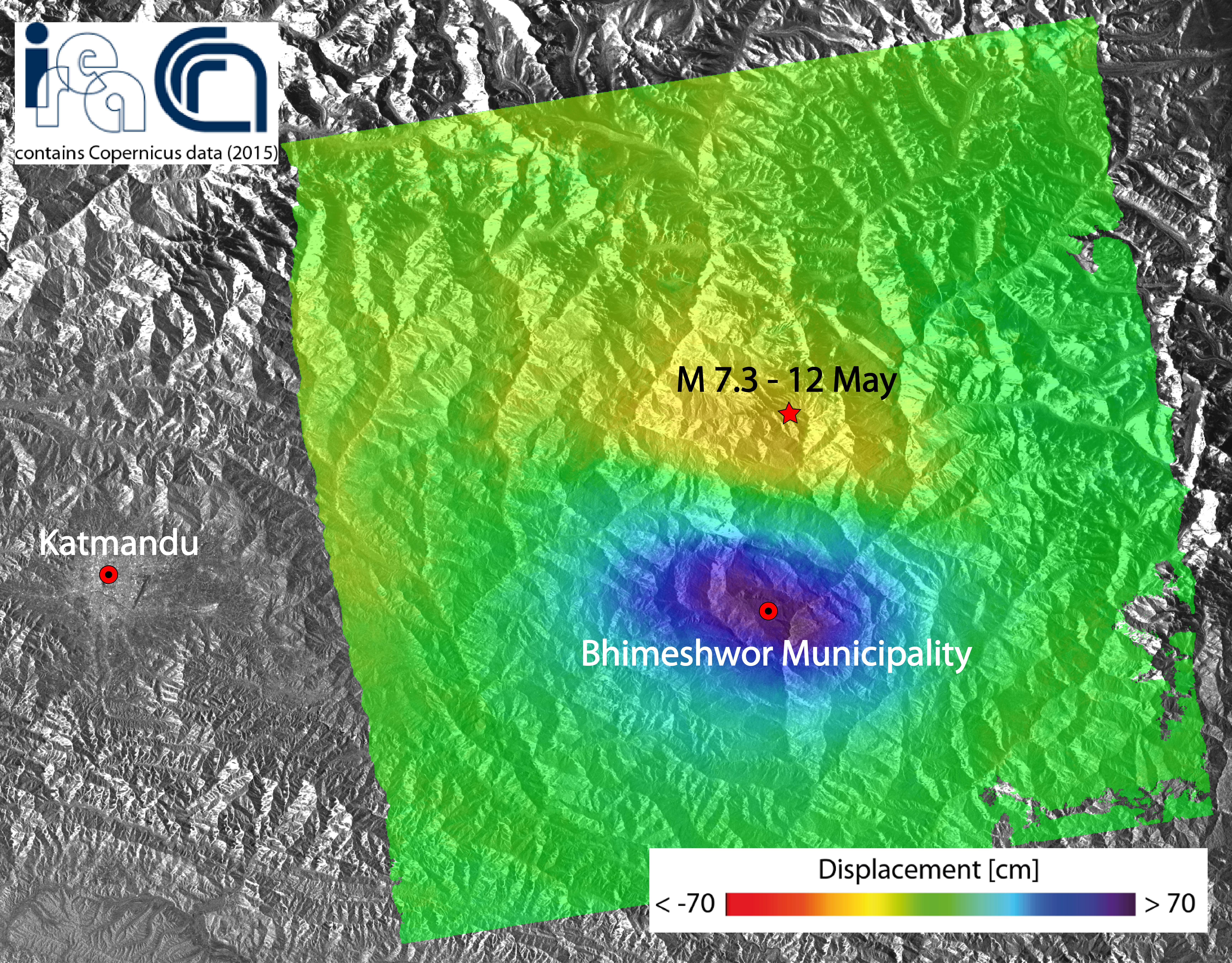
A new earthquake of magnitude 7.3 struck the Nepal area on 12 May 2015 and it is the one that, among all the aftershocks, released the biggest energy after the main event of the last April 25th.
Researchers at the Institute for the Electromagnetic Sensing of the Environment of the Italian National Research Council generated a map of the ground displacement induced by this new earthquake through the Differential SAR interferometry technique, by exploiting data acquired by the Sentinel-1A satellite of the European program Copernicus.
The deformed area extends for about 40 x 60 km2 Eastward of Katmandu. The detected displacement is of about 70 cm toward the satellite in the maximum deforming area (blue zone in the figure).
The measured displacement field has been very likely induced by the same structures involved in the main shock of the last April 25th, and it is compatible with the migration towards East of the aftershocks.
The activity has been conducted as part of the agreement between IREA-CNR and the Civil Protection Department (DPC), and in the framework of the Geohazards Exploitation Platform (GEP) project (ESA) and I-AMICA (High Technological Infrastructure for Integrated Monitoring of Climate and Environment) project, which is funded by MIUR under the National Operative Programme (PON).
To see the image on google earth click here
