
Maria Consiglia Rasulo
A new technique can calculate, through Satellites and GPS data, how the deep magma goes up inside the ground of Campi Flegrei, creating even millimeter deformations of the Earth's surface. A mechanism probably common to other calderas (Yellowstone in the US and Rabaul in Papua New Guinea). The study, published in Scientific Reports, provides new monitoring systems useful to deal with possible future volcanic crises.
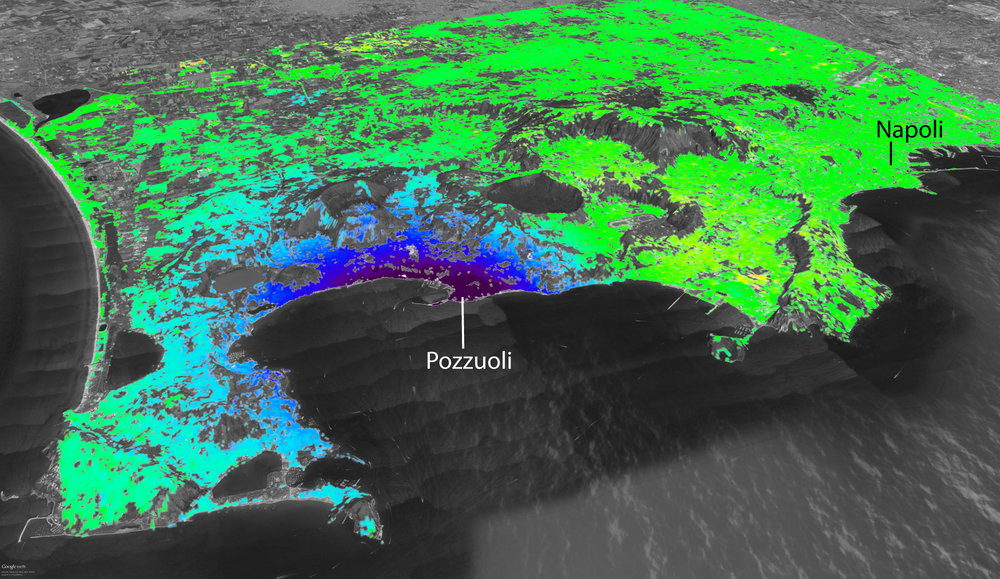
The data acquired from satellites and GPS receivers of the network of sensors placed in the Campi Flegrei area are used to monitor the Earth's surface deformations and to know, in real time, the trend of the ground uplift in the caldera. This is the new monitoring technique developed by a team of researchers from the Institute for Electromagnetic Sensing of the Environment of the National Research Council (CNR-IREA) and the Vesuvius Observatory of the National Institute of Geophysics at Volcanology (INGV- OV), in order to better understand the uplift phenomena occurred in recent years at Campi Flegrei. The study, which is part of the monitoring activities promoted by the Italian Department of Civil Protection (DPC) and those undertaken under the European project MED-SUV (MEDiterraneanSUpersite Volcanoes), was published in Scientific Reports.
"Thanks to the data acquired by the Cosmo-SkyMed satellites (launched by the Italian Space Agency since 2007), equipped with radar systems, and by GPS receivers of the INGV-OV geodetic surveillance network, composed by 14 sensors spread in the Campi Flegrei area", says Susi Pepe, researcher at CNR-IREA," it has been possible to study the deformations, even millimetric, of the Earth's surface and know the trend of the ground uplift in the caldera in correspondence to the receivers".
In the past millennia the Campi Flegrei caldera produced eruptions of gigantic dimensions: forty thousand years ago the Campanian ignimbrite and fifteen thousand years ago the Neapolitan Yellow Tuff, which made the superficial part of the volcano collapse for hundreds of meters, forming the current structure. "After the last eruption in 1538 that produced the Monte Nuovo crater", says Luca D'Auria, the researcher in charge of the Vesuvius Observatory monitoring room, "the ground of the Campi Flegrei began to sink slowly for centuries, untill around 1950, when the area started to raise. This phenomenon, known as bradyseism, showed all its violence between 1982 and 1985, the period when the ground raised almost 2 meters, with accompanying earthquakes, resulting in the evacuation of thousands of residents of the town of Pozzuoli. In 2005 the ground restarted to rise slowly and earthquakes, of low magnitude, reappeared."
Over the past 10 years, the ground has risen almost 30 cm., so much so that in December 2012, based on indications of the Commission Great Risk, the Civil Protection raised the alert level of Campi Flegrei from green (repose) to yellow (warning). "Regarding the origin of the flegrean bradyseism" continues D'Auria, "the scientific community agrees that between 1985 and 2012 the ground uplift was linked to the placing of hydrothermal fluids (water and gas) within the caldera rocks and the progressive heating of the latter. About the most recent episode, between 2012 and 2013, the phenomenon would instead be attributed to the rise of magma at shallow depth (approximately 3 km) that is injected into the subsurface rocks, forming a thin layer, known as the sill, a small "lake underground", with a radius of 2-3 km. The sill was already in the ground and it was probably active during the bradiseismic crises of the past decades when amount of magma, even ten times higher, arrived in this small shallow magma chamber."
The magma within the sill, however, can cool down quickly, thus making it less able to produce explosive eruptions. This mechanism, observed at Campi Flegrei, is probably common to other calderas (for example, Yellowstone in the US and Rabaul in Papua New Guinea) and may explain some behaviors apparently 'bizarre' observed in these volcanoes. "The predictions of volcanic eruptions in the calderas often presents greater difficulties than other volcanoes" adds D'Auria. "The lift and the intrusion of magma within the sill may, in fact, be the normal life cycle of the calderas."
The results of the study are of great importance for the interpretation of the data acquired by the new generations of satellites (like those of the constellation Sentinel of the European Program Copernicus, carried out by the European Space) and the innovative technologies of geophysical monitoring at Campi Flegrei. "These new monitoring systems, integrated with the new methods of analysis, may provide a useful tool to address possible, future volcanic crises at Campi Flegrei" says Susi Pepe at CNR.
Link to the article: www.nature.com/articles/srep13100
Researchers at the Institute for Electromagnetic Sensing of the Environment (IREA) have obtained a drastic improvement in mapping surface deformations thanks to data acquired by the year-old European satellite Sentinel-1A. The result, which opens new perspectives for earthquake and volcano monitoring, has been recently reported on the European Space Agency website.
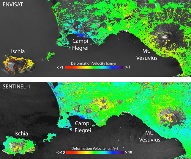
"Our study - said Riccardo Lanari, Director of IREA - clearly demonstrates that we can dramatically increase the spatial coverage of deformation maps, in terms of pixel density, in comparison to the results obtained with previous generations of SAR systems such as ERS and Envisat."
This is evident when comparing the mean deformation velocity maps generated from Sentinel-1A and Envisat data over Napoli Bay (Italy), where three main volcanic complexes – Mount Vesuvius, Campi Flegrei Caldera and Ischia island – are located. In particular, the Sentinel-1A maps clearly show the volcano’s ‘spreading effect’ at the summit of Mount Vesuvius, which was only partially visible with previous products from ERS and Envisat. Also evident is the improvement of the measurement density achieved over the Campi Flegrei Caldera, characterized by an ongoing uplift.
The result has been achieved thanks to the SBAS (Small BAseline Subset) technique developed by IREA researchers, which permits the generation of spatially dense and highly accurate mean deformation velocity maps.
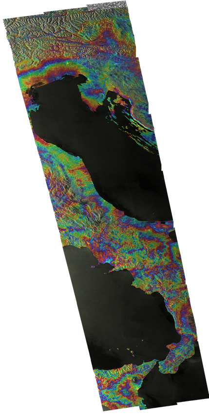
Already worldwide used, this technique is getting a growing interest. This is evidenced, for instance, by the large use of a version of the SBAS technique implemented in the Grid Processing On Demand (GPOD) portal of the ESA Geohazards Exploitation Platform (GEP), which allows users to perform automatic and user-friendly advanced analysis of the Earth's surface deformations by using ERS and Envisat data, and, in a near future, also Sentinel-1 data.
“The possibility to access Sentinel-1 SAR data, with the large coverage and a free and open access data policy, opens new perspectives in civil protection scenarios,” noted Michele Manunta, a researcher of IREA. “For instance, we may already generate, in an operational context, interferograms of nearly the entire Italian territory.”
Surface deformation mapping will be further improved with the upcoming launch of Sentinel-1A’s sister satellite – Sentinel-1B – that will shorten the revisit time from 12 to six days.
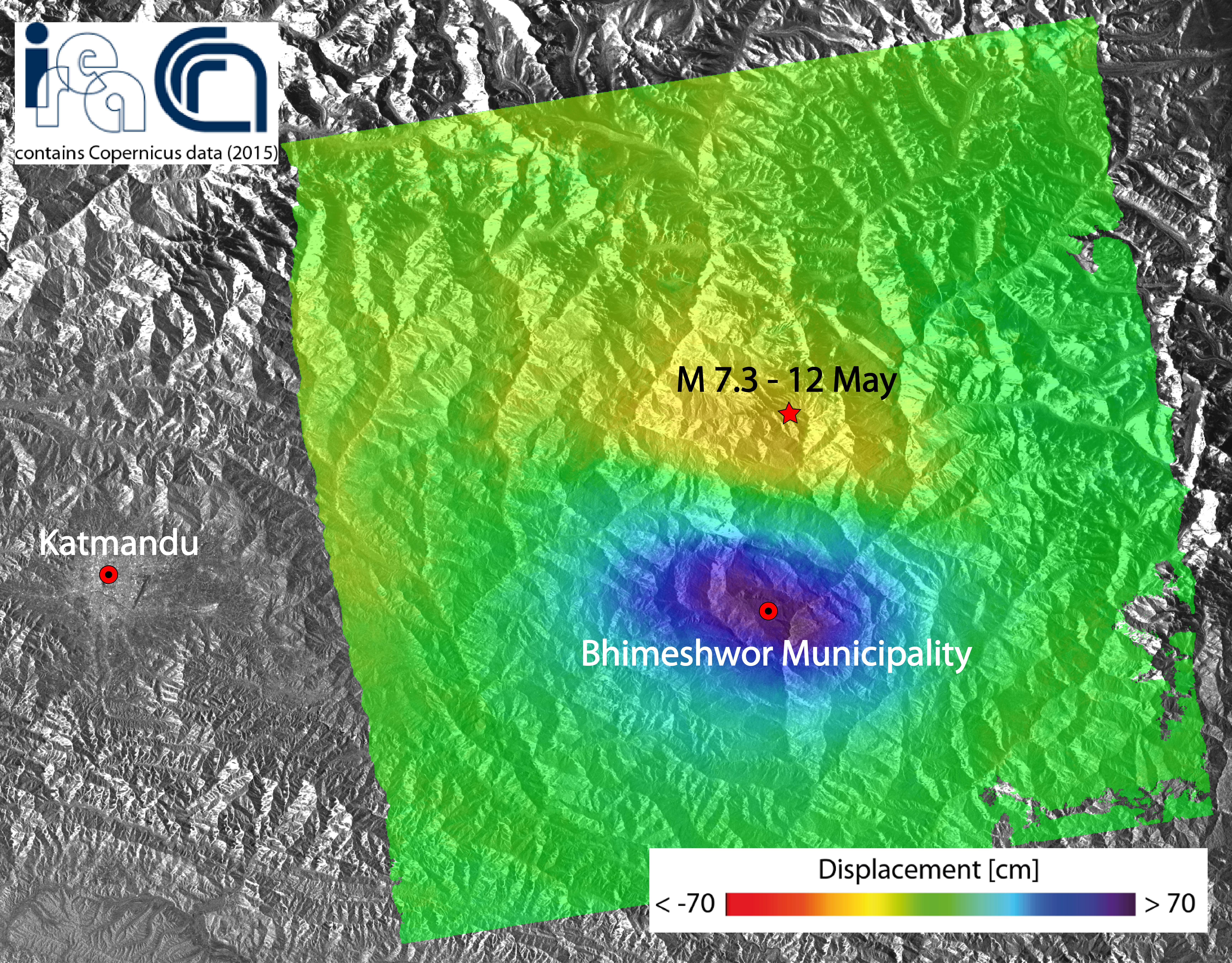
A new earthquake of magnitude 7.3 struck the Nepal area on 12 May 2015 and it is the one that, among all the aftershocks, released the biggest energy after the main event of the last April 25th.
Researchers at the Institute for the Electromagnetic Sensing of the Environment of the Italian National Research Council generated a map of the ground displacement induced by this new earthquake through the Differential SAR interferometry technique, by exploiting data acquired by the Sentinel-1A satellite of the European program Copernicus.
The deformed area extends for about 40 x 60 km2 Eastward of Katmandu. The detected displacement is of about 70 cm toward the satellite in the maximum deforming area (blue zone in the figure).
The measured displacement field has been very likely induced by the same structures involved in the main shock of the last April 25th, and it is compatible with the migration towards East of the aftershocks.
The activity has been conducted as part of the agreement between IREA-CNR and the Civil Protection Department (DPC), and in the framework of the Geohazards Exploitation Platform (GEP) project (ESA) and I-AMICA (High Technological Infrastructure for Integrated Monitoring of Climate and Environment) project, which is funded by MIUR under the National Operative Programme (PON).
To see the image on google earth click here
![]()
The radar acquisitions of the new generation satellite Sentinel-1A of the European Program Copernicus allowed us to analyze the ongoing seismic phenomena and the permanent effects of the ground movements caused by the violent earthquake of magnitude 7.8 that struck Nepal on April 25, 2015.
The study has been conducted by a team of researchers at the Institute for Electromagnetic Sensing of the Environment of the National Research Council of Naples (IREA-CNR) using differential radar interferometry, the technique which allows to measure ground deformations even in the order of a few centimeters on very large areas from space.
The figure shows the obtained interferogram, ie the map of the surface deformation induced by the earthquake, which is in a time interval ranging from April 17 to April 29, 2015. Each color band (fringe) indicates a ground shift of approximately 3 cm, with a maximum deformation of about 1 m. The displacement occurred as a result of the earthquake and subsequent shocks. It is the surface response to the fault plane displacement in depth.
The activity has been conducted as part of the agreement between IREA-CNR and the Civil Protection Department (DPC), and in the framework of the TEP-Quick Win project (ESA) and I-AMICA (High Technological Infrastructure for Integrated Monitoring of Climate and Environment) project, which is funded by MIUR under the National Operative Programme (PON).
To see the image on google earth click here
Contributions in conference proceedings: 2010, 2011, 2012, 2013, 2014, 2015
- Casu F, Manconi A, Bonano M, De Luca C, Elefante S, "3-D Ground Displacement Monitoring of very fast-moving Landslides in Emergency Scenario", European Geosciences Union (EGU) General Assembly.
- Castaldo R, Tizzani P, Solaro G, Pepe S, Riccardo L, "3D Faulting Numerical Model Related To 2009 L'Aquila Earthquake Based On DInSAR Observations", European Geosciences Union (EGU) General Assembly.
- Bevacqua M, Isernia T, Crocco L, Di Donato L, "A (CS)2 approach to inverse scattering", IEEE Conference on Antenna Measurements Applications (CAMA)
- Partescano E, Giorgetti A, Fanara C, Crise A, Oggioni A, Brosich A, Carrara P, “A (Near) Real-time Validation and Standardization System Tested for MAMBO1 Meteo-marine Fixed Station”, 3rd International Conference on Sensor Networks (SENSORNETS 2014).
- Gennarelli G, Catapano I, Persico R, Soldovieri F, “A comparison between two measurement configurations for full 3D GPR imaging”, 8th European Conference on Antennas and Propagation, EuCAP 2014.
- Comite D, Catapano I, Soldovieri F, Galli A, “A customized numerical procedure for accurate target reconstruction through GPR surveys”, European Radar Conference (EuRAD).
- Zeni G, Pepe A, Zhao Q, Bonano M, Gao W, Li X, Ding X “A Differential Sar Interferometry (DINSAR) Investigation of the Deformation Affecting the Coastal Reclaimed Areas of the Shangai Megacity”, International Geoscience and Remote Sensing Symposium (IGARSS).
- Attardo EA, Vecchi G, Crocco L, “A finite element based hybrid source-type scheme for Microwave Imaging”, IEEE International Symposium on Antennas and Propagation Society
- Fugazza C, Oggioni A, Pepe M, Pavesi F, Carrara P, “A holistic, semantics-aware approach to Spatial Data Infrastructures”, DATA 2014 (3rd International Conference on Data Management Technologies and Applications).
- Perna S, Esposito C, Berardino P, Lanari R, Pauciullo A, “A joint approach for phase offset estimation and residual motion error compensation in airborne SAR interferometry”, International Geoscience and Remote Sensing Symposium (IGARSS).
- Berrettoni C, Trono C, Berneschi S, Giannetti A, Tombelli S, Bernini R, Grimaldi AI, Persichetti G, Testa G, Bolzoni L, Porro G, Becker H, Gärtner C, Baldini F, “A newly designed optical biochip for a TDM-POCT device”, Proceedings of SPIE, the International Society for Optical Engineering.
- Noviello C, Fornaro G, Martorella M, Reale D, “A Novel approach for Motion Compensation in ISAR System”, EUSAR 2014; 10th European Conference on Synthetic Aperture Radar.
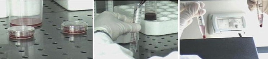
- Lamberti P, Romeo S, Sannino A, Scarfì MR, Tucci V, Zeni O, “A numerical and experimental analysis of electroporation in mammalian cells exposed to ns pulsed electric fields”, III Convegno Nazionale Interazioni tra Campi Elettromagnetici e Biosistemi.
- Romeo S, Sannino A, Zeni O, Scarfì MR, Massa R, Cerciello V, d'Angelo R, “A numerical tool to evaluate occupational exposure in MRI”, III Convegno Nazionale Interazioni tra Campi Elettromagnetici e Biosistemi.
- Crocco L, Ferrara V, “A review on ground penetrating radar technology for the detection of buried or trapped victims”, International Conference on Collaboration Technologies and Systems (CTS).
- Manunta M, Calò F, De Luca C, Elefante S, Farres J, Guzzetti F, Imperatore P, Lanari R, Lengert W, Zinno I, Casu F, “A sustainability model based on cloud infrastructures for core and downstream Copernicus services”, European Geosciences Union (EGU) General Assembly.
- Romeo S, Zeni O, Sannino A, Zeni L, Scarfì MR, “A versatile, nanosecond electric pulse generation system for in vitro bioelectric research studies”, III Convegno Nazionale Interazioni tra Campi Elettromagnetici e Biosistemi.
- Fontanelli G, Crema A, Azar R, Stroppiana D, Villa P, Boschetti M, “Agricultural crop mapping using optical and SAR multi-temporal seasonal data: A case study in Lombardy region, Italy”, International Geoscience and Remote Sensing Symposium (IGARSS).
- Boschetti M, Nelson A, Confalonieri R, Manfron G, Busetto L, Nutini F, Pagani V, Raviz J, Rala A, Mabalay M, Quilang J, Bacong A, Barbieri M, “An automatic approach to analyse optical satellite imagery time series for rice monitoring and status assessment: applications in yield estimation in Senegal and rapid assessment of typhoon damages in Philippines”, 4th International Rice Congress.
- Romeo S, D'Avino C, Pinchera D, Zeni O, Scarfì MR, Massa R, “An exposure system for in vitro bioelectromagnetic studies under multiple-frequency scenarios”, III Convegno Nazionale Interazioni tra Campi Elettromagnetici e Biosistemi.
- Comite D, Galli A, Catapano I, Soldovieri F, Pettinelli E, “An improved tomographic approach for accurate target reconstruction from GPR numerical data”, 15th International Conference on Ground Penetrating Radar (GPR).
- Bernini R, Catapano I, Soldovieri F, Crocco L, “An integrated sensing technique for smart monitoring of water pipelines”, European Geosciences Union (EGU) General Assembly.
- Nicodemo G, Ferlisi S, Peduto D, Cascini L, Gullà G, Borrelli L, Fornaro G, “Analisi di livello preliminare delle conseguenze indotte agli edifice da frane a cinematica lenta”, Incontro Annuale Ricercatori di Geotecnica - IARG.
- Balik Sanli F, Calò F, Abdikan S, Pepe A, Gorum T, “Analysis of deformation patterns through advanced DINSAR techniques in Istanbul megacity”, ISPRS Technical Commission VII Symposium.
- Minardo A, Bernini R, Zeni L, “Analysis of the Brillouin gain spectrum in a graded-index multimode fiber”, Mediterranean Photonics Conference.
- Villa P, Boschetti M, Scozzari A, Vignudelli S, “Analysis of vegetation dynamics in middle east area during 2002-2013 in relation to the 2007-2009 drought episode”, International Geoscience and Remote Sensing Symposium (IGARSS).
- Sica F, Alparone L, Argenti F, Fornaro G, Lapini A, Reale D, “Benefits of blind speckle decorrelation for InSAR processing”, XIV Conference on SAR Image Analysis, Modeling, and Techniques.
- Pepe M, Basoni A, Bastianini M, Fugazza C, Menegon S, Oggioni A, Pavesi F, Sarretta A, Carrara P, “Bottom-up capacity building for data providers in RITMARE”, European Geosciences Union (EGU) General Assembly.
- Nobile A, Pepe S, Ruch J, Trippanera D, Casu F, Castaldo R, Tizzani P, Aoki Y, Geshi N, Acocella V, Sansosti E, Siniscalchi V, Borgstrom S, Zoffoli S, “Caldera deformation in Kyushu island (SW Japan) through InSAR data”, EGU General Assembly.
- Mossucca L, Zinno I, Elefante S, De Luca C, Casola V, Terzo O, Casu F, Lanari R, “Cloud Platform for Scientific Advances in Earth Surface Interferometric SAR Image Analysis”, IEEE 6th International Conference on Cloud Computing Technology and Science (CloudCom).
- Bevacqua MT, Di Donato L, Crocco L, Isernia T, “Conditioning Inverse Scattering Problems by Means of Suitably Designed Synthetic Experiments”, 8th European Conference on Antennas and Propagation, EuCAP.
- Azar R, Fontanelli G, Villa P, “Crop monitoring using X-band SAR interferometry in the lombardy region, Italy”, SPIE Remote Sensing 2014.
- Manzo M, Walter TR, “Deforming Merapi: High resolution InSAR time series reveals displacement occurrence at the volcano summit and at the volcano flanks”, Cities on Volcanoes.
- Hestir EL, Bresciani M, Giardino C, Brando V, Matta E, Villa P, Dekker A, “Detection and monitoring capabilities of future satellite sensors for lakes and reservoirs”, 15th World Lake Conference WLC) - Lakes: the mirrors of the earth.
- Minardo A, Picarelli L, Coscetta A, Zeni G, Esposito G, Sacchi M, Matano F, Caccavale M, Zeni L, “Distributed Fiber Optic Sensors for Early Detection of Rocky Slopes Movements”, European Geosciences Union (EGU) General Assembly.
- Lavender S, Brito F, Aas C, Casu F, Ribeiro R, Farres J, “E-Collaboration for Earth Observation (E-CEO) with the example of Contest #3 that focuses on the Atmospheric Correction of Ocean Colour data”, European Geosciences Union (EGU) General Assembly.
- Casu F, Manunta M, Boissier E, Brito F, Aas C, Lavender S, Ribeiro R, Farres J, “e-Collaboration for Earth observation (E-CEO): the Cloud4SAR interferometry data challenge”, European Geosciences Union (EGU) General Assembly.
- Scarfì MR, “Effetti biologici di co-esposizioni a campi elettromagnetici non ionizzanti e altri agenti chimici o fisici”, 31° Congresso Nazionale di Igiene Industriale.
- Scozzari A, Gómez E, Jesús X, Soldovieri F, Vignudelli S, “Experimentation of a tomographic technique on envisat radar altimetry data: Oil platforms as an opportunity target”, International Geoscience and Remote Sensing Symposium (IGARSS).
- Marsella M, Scifoni S, Scutti M, Sonnessa A, Bonano M, Ojha C, Manunta M, Pepe A, Solaro G, “Exploitation of the results of an extend DInSAR analysis performed since 1992 in the urban area of Roma”, European Geosciences Union (EGU) General Assembly.
- Di Donato L, Bevacqua MT, Crocco L, Isernia T, “Exploiting Compressive Sensing in Microwave Tomography and Inverse Scattering”, 8th European Conference on Antennas and Propagation, EuCAP.
- Minardo A, Picarelli L, Avolio B, Coscetta A, Papa R, Zeni G, Di Maio C, Vassallo R, Zeni G, “Fiber Optic Based Inclinometer for Remote Monitoring ff Landslides: On Site Comparison with Traditional Inclinometers“, International Geoscience and Remote Sensing Symposium (IGARSS).
- Zamparelli V, Agram PS, Fornaro G, “Focusing of COSMO/SkyMed spotlight data with discrete antenna steering”, International Geoscience and Remote Sensing Symposium (IGARSS).
- Di Martino G, Franceschetti G, Iodice A, Riccio D, Ruello G, Zinno I, “Fractal dimension estimation from fully polarimetric SAR data”, International Geoscience and Remote Sensing Symposium (IGARSS).
- Riccio D, Di Martino G, Iodice A, Ruello G, Zinno I, “Fractal dimension images from SAR images”, IEEE International Conference on Image Processing (ICIP).
- Candiani G, Manfron G, Pepe M, Courault D, Boschetti M, “From multi-temporal mapping to time series analysis with high spatial resolution data: evaluation of SPOT4 take5 data to simulate sentinel-2 contribution”, EARsEL 2014 - 5th Land Use & Land Cover Workshop.
- Catapano I, Soldovieri F, Affinito A, Hugenschmidt J, “Full 3D Microwave Tomography enhanced GPR surveys: a case study”, European Geosciences Union (EGU) General Assembly.
- Bonano M, Arangio S, Calò F, Di Mauro M, Marsella M, Manunta M, “Fully exploitation of SBAS-DInSAR deformation time series for assessing structural damage: the case study of Rome, Italy”, European Geosciences Union (EGU) General Assembly.
- Candiani G, Bordogna G, Manfron G, Boschetti M, Pepe M, “Fusion of remote sensing dataset with heterogeneous spatio-temporal resolution: simulation of sentinel-2 time series of vegetation indexes for agricultural monitoring”, SENTINEL-2 for Science Workshop.
- Candiani G, Manfron G, Boschetti M, Busetto L, Nutini F, Crema A, Pepe M, Bordogna G, “Fusione di immagini telerilevate provenienti da dataset eterogenei: ricostruzione di serie temporali ad alta risoluzione spazio-temporale”, 18a Conferenza Nazionale ASITA.
- Bordogna G, Ienco D, “Fuzzy Core DBScan Clustering Algorithm”, Information Processing And Management of Uncertainty in Knowldge Based Systems (IPMU).
- Massa R, Pugliese M, Quarto M, Roca V, Romeo S, Scarfì MR, Zeni O, "General public exposure to electromagnetic fields and radon in urban environment”, III Convegno Nazionale Interazioni tra Campi Elettromagnetici e Biosistemi.
- Almeida ER, Porsani JL, Catapano I, Gennarelli G, Soldovieri F, “GPR data analysis enhanced by microwave tomography for forensic archaeology”, 15th International Conference on Ground Penetrating Radar (GPR).
- Persico R, Gennarelli G, Soldovieri F, “GPR prospecting on circular surfaces: preliminary results”, 15th International Conference on Ground Penetrating Radar.
- Bonano M, Calò F, Manunta M, Marsella M, Scifoni S, Sonnessa A, Tagliafierro V, “Ground settlement assessment in urban areas through SBAS-DInSAR measurements: the case study of Roma (Italy)”, IAEG XII Congress.
- Lengert W, Farres J, Lanari R, Casu F, Manunta M, Lassalle-Balier G, “Helix Nebula: Enabling federation of existing data infrastructures and data services to an overarching cross-domain e-infrastructure”, European Geosciences Union (EGU) General Assembly.
- Casteleyn S, Granell Canut C, Trilles Oliver S, Huerta Guijarro J, Boschetti M, Busetto L, Pepe M, Katsantonis D, Confalonieri R, Holecz F, García Haro J, Gitas I, “How Earth Observation, Crop Modeling, and ICT can help rice cultivation: the ERMES project”, International Conference on Geographic Information Science.
- Pompilio L, Pepe M, Candiani G, “Hyperdimensional data exploitation through parametric reduction”, 6th Workshop on Hyperspectral Image and Signal Processing: Evolution in remote Sensing.
- Giardino C, Bresciani M, Matta E, Brando V, "Hyperspectral Observations of Optical Properties in Lakes in Perspective of Future Satellite Sensors - A Case Study in Italy”, Whispers.
- Galli A, Comite D, Catapano I, Soldovieri F, “Implementation of a synthetic imaging technique for GPR non-destructive testing”, European Geosciences Union (EGU) General Assembly.
- Fornaro G, Pauciullo A, Reale D, Verde S, “Improving SAR Tomography Urban Area Imaging and Monitoring with CAESAR", 10th European Conference on Synthetic Aperture Radar (EUSAR).
- Fornaro G, Pauciullo A, Reale D, Verde S, “Improving SAR tomography via CAESAR for built structures monitoring: An application to COSMO-SKYMED data”, International Geoscience and Remote Sensing Symposium (IGARSS).
- Cilia C, Panigada C, Rossini M, Pepe M, Candiani G, Colombo R, “Individuazione di coperture in cemento-amianto e del loro deterioramento da immagini iperspettrali”, 18a Conferenza Nazionale ASITA.
- Boschetti L, Smith A, Keefe R, Hudak A, Brivio PA, “Industrial forest mapping: a Landsat Spatial and Temporal Approach”, 6th Int. Conference ForestSAT.
- Solaro G, Castaldo R, Casu F, De Luca C, Marsella M, Pepe A, Pepe S, Ruch J, Sansosti E, Scifoni S, Tizzani P, Zeni G, “Insights Into The Dynamics Of Aeolian Volcanic Islands From DInSAR COSMO-SkyMed Observations”, European Geosciences Union (EGU) General Assembly.
- Gullà G, Fornaro G, Borrelli L, Antronico L, Reale D, Verde S, “Integrazione progressiva di dati geotecnici e da satellite nell'analisi del rischio da frana in area urbana: il quartiere di Ianò-Catanzaro”, XXV Convegno Nazionale di Geotecnica.
- Tizzani P, Battaglia M, Castaldo R, Pepe A, Zeni G, Lanari R, “Interplay Between Tectonics And Volcanic Processes Active In The Yellowstone Caldera Detected Via DInSAR And GPS Time-Series”, European Geosciences Union (EGU) General Assembly.
- Bevacqua M, Isernia T, Crocco L, Di Donato L, “Inverse scattering through Compressive sensing and synthetic experiments”, IEEE International Symposium on Antennas and Propagation Society.
- Noviello C, Fornaro G, Martorella M, Reale D, “ISAR add-on for focusing moving targets in very high resolution spaceborne SAR data”, International Geoscience and Remote Sensing Symposium (IGARSS).
- Frigerio L, Kliment T, Crema A, Stroppiana D, Bordogna G, Boschetti M, Brivio PA, “L'Infrastruttura di Dati Spaziali del progetto Space4Agri a supporto del monitoraggio del settore agricolo in Lombardia”, 18° Conf. Naz. ASITA.
- Persichetti G, Testa G, Bernini R, “Liquid jet waveguide for Raman spectroscopy”, Photonic west.
- Persichetti G, Testa G, Bernini R, “Liquid Jet Waveguide for Spectroscopic Sensors”, 16mo Convegno nazionale delle Tecnologie Fotoniche (Fotonica 2014).
- Oggioni A, Basoni A, Bastianini M, Fugazza C, Menegon S, Pavesi F, Pepe M, Sarretta A, Carrara P, “Lo StarterKit RITMARE: uno strumento abilitante per la costruzione bottom-up di un'infrastruttura di dati marini”, 18a Conferenza Nazionale ASITA.
- Bucci OM, Bellizzi G, Crocco L, Scapaticci R, Di Massa G, Costanzo S, Borgia A, “Magnetic Nanoparticle Enhanced Microwave Imaging: Towards an Experimental Feasibility Assessment”, 8th European Conference on Antennas and Propagation (EuCAP).
- Catapano I, Soldovieri F, Gonzalez-Huici M, “A Microwave tomography enhanced Forward Looking GPR: A feasibility analysis”, 15th International Conference on Ground Penetrating Radar (GPR).
- Romeo S, Sannino A, Zeni O, Scarfì MR, Massa R, Cerciello V, d'Angelo R, “Monitoraggio dell'esposizione dei lavoratori in risonanza magnetica: analisi numerica e sperimentale”, 31° Congresso Nazionale di Igiene Industriale.
- Busetto L, Strobl P, Huston Durrant T, Boca R, Boccacci F, Camia A, San Miguel-Ayanz J, “Monitoring post-fire vegetation green vegetation cover dynamics in European Burnt Areas from MODIS scaled NDVI time series”, ForestSAT.
- Guglielmino F, Puglisi G, Bonforte A, Cocorullo C, Sansosti E, Pepe S, Solaro G, Casu F, Acocella V, Ruch J, Nobile A, Zoffoli S, "Mt. Etna ground deformation detected by SISTEM approach using GPS data and multiple SAR sensor”, European Geosciences Union (EGU) General Assembly.
- Bevacqua M, Isernia T, Crocco L, Di Donato L, “New approaches to inverse scattering exploiting synthetic experiments”, IEEE International Symposium on Antennas and Propagation Society.
- Crocco L, Di Donato L, Sorbello G, “New tomographic imaging strategies for GPR surveys”, 15th International Conference on Ground Penetrating Radar (GPR).
- Pinardi M, Soana E, Bresciani M, Villa P, Bartoli M, “Nitrogen removal in a fluvial wetland: macrophyte-bacteria interactions and relevance at the basin scale”, Wetlands.
- Pepe S, Castaldo R, De Luca C, Casu F, Tizzani P, Sansosti E, “Ongoing Active Deformation Processes At Fernandina Volcano (Galapagos) Detected Via Multi-Orbital CosmoSkyMed SAR Sensors Analysis”, European Geosciences Union (EGU) General Assembly.
- Berrettoni C, Berneschi S, Bernini R, Giannetti A, Grimaldi IA, Persichetti G, Testa G, Tombelli S, Trono C, Baldini F, “Optical Monitoring of Therapeutic Drugs with a Novel Fluorescence- Based POCT Device”, EUROSENSORS 2014, the 28th European Conference on Solid-State Transducers.
- Testa G, Persichetti G, Bernini R, “Optimization of a hybrid silicon-polymer optical ring resonator”, Secondo Convegno Nazionale Sensori.
- Testa G, Persichetti G, Sarro P, Bernini R, “Optofluidic hybrid platform with integrated solid core waveguides”, SPIE, the International Society for Optical Engineering.
- Persichetti G, Testa G, Bernini R, “Optofluidic jet waveguide sensor for raman spectroscopy”, Secondo Convegno Nazionale Sensori.
- Persichetti G, Testa G, Bernini R, “Optofluidic jet waveguides as new tool for sensing”, EUROPTRODE XII Conference on Optical Chemical Sensors & Biosensors.
- Basoni A, Bordogna G, Carrara P, Criscuolo L, Frigerio L, Fugazza C, Kliment T, Lella S, Menegon S, Mangioni E, Oggioni A, Pavesi F, Pepe M, Rampini A, Sterlacchini S, Tagliolato P, “Personalization and Contextualization of Access to Spatial Data Infrastructures”, Convegno Nazionale "GIT- Geosciences and Information Technology".
- Granström K, Natale A, Vraca P, Ludeno G, Serafino F, “PHD extended target tracking using an incoherent X-band radar: Preliminary real-world experimental results”, Fusion.
- Diao F, Walter TR, Wang R, Manzo M, Lanari R, “Postseismic deformation near Istanbul: evidence from long-term InSAR observation and modelling”, European Geosciences Union (EGU) General Assembly.
- Fornaro G, Reale D, Verde S, Peduto D, Arena L, Ferlisi S, “Potentialities of the use of spaceborne radar systems in the monitoring of structures and infrastructures”, IEEE Workshop on Environmental, Energy and Structural Monitoring Systems.
- Sannino A, Zeni O, Romeo S, Massa R, Vijayalaxmi, Scarfì MR, “Protective effects of non-ionizing radiofrequency fields in mammalian cells damaged by mutagens: a possible involvement of DNA repair mechanism”, III Convegno Nazionale Interazioni tra Campi Elettromagnetici e Biosistemi.
- Di Donato L, Crocco L, Bevacqua M, Isernia T, “Quasi Invisibility via inverse scattering techniques”, IEEE Conference on Antenna Measurements Applications (CAMA).
- Catapano I, Affinito A, Crocco L, Soldovieri F, “Radar Systems for Infrastructures Diagnostics: A Review”, EWSHM-7th European Workshop on Structural Health Monitoring.
- Fugazza C, Oggioni A, Pepe M, Carrara P, “Rappresentare Ricercatori e Istituti del Progetto RITMARE nel Web Semantico”, 18a Conferenza Nazionale ASITA.
- Persico R, Gennarelli G, Soldovieri F, “Reconstruction of buried objects embedded in circular opaque structures”, European Geosciences Union (EGU) General Assembly.
- Fugazza C, Basoni A, Menegon S, Oggioni A, Pavesi F, Pepe M, Sarretta A, Carrara P, “RITMARE: Semantics- Aware harmonisation of data in Italian marine research”, Current Research Information Systems 2014 (CRIS2014).
- Imperatore P, Zinno I, Elefante S, De Luca C, Manunta M, Casu F, “Scalable performance analysis of the parallel SBAS-DInSAR algorithm”, International Geoscience and Remote Sensing Symposium (IGARSS).
- Costa F, Sannino A, Bucci OM, “Selective Targeting of Magnetic Nanoparticles for Contrast Enhanced Microwave Imaging: a Preliminary Study”, III Convegno Nazionale Interazioni tra Campi Elettromagnetici e Biosistemi.
- Oggioni A, Bastianini M, Carrara P, Minuzzo T, Pavesi F, “Sensing Real-Time observatories in marine sites: a proof-of-concept”, 3rd International Conference on Sensor Networks (SENSORNETS).
- Bisquert M, Bordogna G, Boschetti M, Poncelet P, Teisseire M, “Soft Fusion of Heterogeneous Image Time Series”, Information Processing And Management of Uncertainty in Knowldge Based Systems (IPMU).
- Nutini F, Stroppiana D, Bellingeri D, Boschetti M, Brivio PA, Zini E, “Stima della frazione evaporativa delle colture in Lombardia da dati meteo e satellitari MODIS nell'ambito del progetto Space4Agri”, 18a Conferenza Nazionale ASITA.
- Manzo M, Del Gaudio C, De Martino P, Ricco C, Tammaro U, Castaldo R, Tizzani P, Lanari R, “Surface deformation time-series analysis at Ischia Island (South Italy) carried out via multi-platform monitoring systems”, European Geosciences Union (EGU) General Assembly.
- Bordogna G, Brivio PA, Boschetti M, Carrara P, Crema A, Frigerio L, Kliment T, L'Astorina A, Oggioni A, Pepe M, Rampini A, Stroppiana D, Tomasoni I, Villa P, “Tecnologie e Agricoltura: l'esperienza nel progetto Space4Agri applicata al caso di Bergamo”, Convegno Internazionale "BERGAMO S-LOW AGRI AND GREEN SPACES IN THE CITY".
- Perna S, Amaral T, Berardino P, Esposito C, Pauciullo A, Vaz JE, Wimmer C, Lanari R, “Telaer airborne SAR system upgraded to the interferometrio mode: Flight test result”, International Geoscience and Remote Sensing Symposium (IGARSS).
- Perna S, Amaral T, Berardino P, Esposito C, Jackson G, Pauciullo A, Vaz JE, Wimmer C, Lanari R, “TELAER: a multi-mode/multi-antenna interferometric airborne SAR system”, European Geosciences Union (EGU) General Assembly.
- Catapano I, Soldovieri F, “Terahertz spectroscopy and imaging for cultural heritage management: state of art and perspectives”, European Geosciences Union (EGU) General Assembly.
- Casu F, Castaldo R, De Luca C, Solaro G, “The 2014 Napa Earthquake Imaged Through A Full Exploitation Of SAR Data”, AGU Fall Meeting.
- Salvi S, Tolomei C, Pezzo G, Lanari R, Pepe A, Marchetti PG, Della Vecchia A, Mantovani S, “The InSAR Italy portal for open access to crustal deformation data”, European Geosciences Union (EGU) General Assembly.
- Castaldo R, Tizzani P, Lollino P, Calò F, Ardizzone F, Manunta M, Guzzetti F, Lanari R, “The Ivancich active landslide process (Assisi, Central Italy) analysed via numerical modeling jointly optimized by DInSAR and inclinometric data”, IAEG XII Congress.
- Zinno I, De Luca C, Elefante S, Imperatore P, Manunta M, Casu F, “The Parallel SBAS-DInSAR algorithm: an effective and scalable tool for Earth's surface displacement retrieval”, European Geosciences Union (EGU) General Assembly.
- Fugazza C, Menegon S, Oggioni A, Pepe M, Carrara P, "The RITMARE Starter Kit: Bottom-up capacity building for geospatial data providers”, ICSOFT 2014 (9th International Conference on Software Paradigm Trends).
- Manunta M, Berardino P, Bonano M, De Luca C, Elefante S, Fusco A, Lanari R, Manzo M, Pepe A, Sansosti E, Zinno I, Casu F, “The SBAS-DInSAR processing chain for Interferometric Wide Swath Sentinel-1 data”, Sentinel-1 INSARAP Workshop.
- Baldini F, Berneschi S, Bernini R, Berrettoni C, Giannetti A, Grimaldi IA, Persichetti G, Testa G, Tombelli S, Trono C, “Therapeutic drug monitoring using a POCT format: The NANODEM European Project”, EUROPTRODE XII Conference on Optical Chemical Sensors & Biosensors.
- Elefante S, Manconi A, Bonano M, De Luca C, Casu F, “Three-dimensional ground displacements retrieved from SAR data in a landslide emergency scenario”, International Geoscience and Remote Sensing Symposium (IGARSS).
- Crocco L, Di Donato L, Iero D, Isernia T, Scapaticci R, “Three-dimensional Power Focusing and Shaping for Effective Hyperthermia Treatment Planning”, 8th European Conference on Antennas and Propagation (EuCAP).
- Beck P, Busetto L, San Miguel-Ayanz J, Boca R, Boccacci F, “Towards multi-sensor operational monitoring of the European fire regime”, AGU Fall Meeting.
- Basoni A, Carrara P, Crema A, L'Astorina A, Pepe M, “Una metodologia per l'analisi di bisogni e requisiti degli utenti del Progetto Space4Agri”, 18a Conferenza Nazionale ASITA.
- Scapaticci R, Kosmas P, Crocco L, “Wavelet-based Distorted Born Iterative Method for Accurate Microwave Imaging of Breast Tissues”, 8th European Conference on Antennas and Propagation (EuCAP).
Contributions in conference proceedings: 2010, 2011, 2012, 2013, 2014, 2015
- Petrazzuoli L, Persichetti G, Onorato G, Grimaldi IA, Testa G, Bernini R, "A fuel level sensor for aeronautical applications", Proceedings of SPIE, Photonic Instrumentation Engineering II.
- L'Astorina A, Tomasoni I, "A participative model for undertaking and evaluating scientific communication in Earth Observation researches", EGU General Assembly 2015.
- Tombelli S, Trono C, Adinolfi B, Chiavaioli F, Giannetti A, Eugen-Olsen J, Bernini R, Grimaldi IA, Persichetti G, Testa G, Baldini F, "Optical heterogeneous bioassay for the detection of the inflammatory biomarker suPAR", Photonic West 2015.
- L'Astorina A, Tomasoni I, "Researchers go to School: understanding the content and the procedures of science through a new dialogue among students, teachers and scientists", EGU General Assembly 2015
- Casu F, Manconi A, Elefante S, Zinno I, "Surface Displacement Time Series Retrieved by Fully Exploiting Space-Borne SAR Data", XII IAEG Congress.
- Ferlisi S, Peduto D, Gullà G, Nicodemo G, Borrelli L, Fornaro G, "The use of DInSAR data for the analysis of building damage induced by slow-moving landslides", Engineering Geology for Society and Territory.
-
Brivio PA, Boschetti M, Carrara P, Stroppiana D, "Continental wide assessment of vegetation cover anomalies from time series of satellite products", in "Remote Sensing Optical Observations of Vegetation Properties", Maselli F, Menenti M, Brivio PA (Eds), Research Signpost, Trivandrum (India), pp 165-187.
-
Crocco L, "Detection of Concealed Targets in Through-the-Wall Imaging", in "Through the Wall Radar Imaging", Amin M (Ed.), CRC Press, pp 449-470.
-
Soldovieri F, Solimene R, "Ground Penetrating Radar Subsurface Imaging of Buried Objects", in "Radar Technology", Kouemou G (Ed.), InTech, DOI: 10.5772/7176.
-
Sarabandi K, Thiel M, Dehmollaian M, Solimene R, Soldovieri F, "Inverse Scattering Approaches in Through-the-Wall Imaging", in "Through-the-Wall Radar Imaging", Amin M (Ed.), CRC Press, pp 185-215.
-
Bernini R, Zeni L, "Optoelectronics", in "Handbook of Optofluidics", Hawkins AR, Schmidt H (Eds.), CRC Press, pp 5-1 ; 5-33.
-
L'Astorina A, "Sperimentazione di VIS rapida simultanea", in "La Valutazione di Impatto sulla Salute (VIS) - Quaderni di Moniter" Collana di documentazione a cura di Servizio Comunicazione, Educazione alla sostenibilità, Autori: Ballarini A, Bedeschi M, Bianchi F, Cori L, Linzalone N, Natali M, Regione Emilia-Romagna, pp 53-57.
-
Zeni O, Sannino A, Romeo S, Scarfì MR, Coderoni L, Micciulla F, Sacco I, Bellucci S, “Cytotoxicity of Multiwalled Carbon Nanotube Buckypaper in Human Lymphocytes”, in Sensors and Microsystems, Lecture notes in electrical engineering, Vol. 91, pp 489-493.
-
Soldovieri F, Lapenna V, Bavusi M, “Electromagnetic methods and sensors for water monitoring”, in Water Security in the Mediterranean Region, Andrea Scozzari, Bouabid El Mansouri (Eds), NATO Science for Peace and Security Series C: Environmental Security, pp 65-86.
-
Soldovieri F, Crocco L, “Electromagnetic Tomography”, in Subsurface Sensing, A. S. Turk, K. A. Hocaoglu, A. A. Vertiy (Eds), Wiley Series in Microwave and Optical Engineering, John Wiley & Sons, pp 228-255.
-
Stroppiana D, Fava F, Boschetti M, Brivio PA, “Estimation of nitrogen content in crops and pastures using hyperspectral vegetation indices”, in Hyperspectral Remote Sensing of Vegetation, Alfredo Thenkabail , Prasad S . Lyon , and John G . Huete (Eds), CRC Press, pp 245–262.
-
Bordogna G, Bucci F, Carrara P, Pepe M, Rampini A, “Flexible Querying of Imperfect Temporal Metadata in Spatial Data Infrastructures”, in Advanced Database Query Systems: Techniques, Applications and Technologies, Li Yan and Zongmin Ma (Eds), IGI Global, pp 140-159.
-
Bordogna G, Boschetti M, Brivio PA, Carrara P, Pagani M, Stroppiana D, “Fusion Strategies based on the OWA Operator in Environmental Applications”, in Recent Developments in the Ordered Weighted Averaging Operators: Theory and Practice, Kacprzyk J, Yager RR, Beliakov G, (Eds), Sprinter Verlag, pp 189-207.
-
Crocco L, Soldovieri F, “Nonlinear Inversion Algorithms”, in Subsurface Sensing, A. S. Turk, K. A. Hocaoglu, A. A. Vertiy (Eds), Wiley Series in Microwave and Optical Engineering, John Wiley & Sons, pp 365-387.
-
L'Astorina A, “Ricercare e Comunicare - Indagine conoscitiva sulle attività di comunicazione negli istituti di ricerca del Consiglio Nazionale delle Ricerche”, in La scienza condivisa - idee e pratiche di ricercatori che comunicano la scienza, Valente A (a cura di), Scienza Express edizioni, Milano.
-
De Carolis G, Adamo M, De Pasquale V, Pasquariello G, “The detection of marine oil slicks in VNIR satellite images: the role of sunglint”, in Marine Research at Cnr, Brugnoli E, Cavarretta G, Mazzola S, Trincardi F, Ravaioli M, Santoleri R (a cura di), Consiglio Nazionale delle Ricerche, Dipartimento Terra e Ambiente, Volume DTA/06-2011, pp 1625-1637.
-
Giardino C, Bresciani M, Bartoli M, “Water quality remote sensing of the largest European lagoon”, in Marine Research at CNR, Edito da Brugnoli E. et al., Consiglio Nazionale delle Ricerche, Dipartimento Terra e Ambiente, Volume DTA/06-2011, pp 2415-2427.
-
Pepe A, “Advanced Multitemporal Phase Unwrapping Techniques for DInSAR Analyses”, in Recent Interferometry Applications in Topography and Astronomy, Ivan Padron (Ed.), InTech, pp 57-82.
-
Zeni O, Scarfì MR, “Experimental Requirements for in vitro Studies Aimed to Evaluate the Biological Effects of Radiofrequency Radiation”, in Microwave Materials Characterization, Sandra Costanzo (Ed.), InTech, pp 121-138.
-
Bresciani M, Giardino C, Villa P, “Il Telerilevamento applicato allo studio del Lago Trasimeno”, in Tutela Ambientale del Lago Trasimeno, Martinelli A. (Ed.), ARPA Umbria, pp 157-201.
-
Pasi G, Bordogna G, Jain L, “An introduction to quality issues in the management of web information”, in “Quality Issues in the Management of Web Information”, Pasi G, Bordogna G, Jain L (Eds,), Springer Berlin Heidelberg, pp 1-3.
-
Villa P, Molina R, Gomarasca MA, “Data harmonisation in the context of the European spatial data infrastructure: the HUMBOLDT project framework and scenarios”, in “Earth Observation of Global Changes (EOGC)”, Krisp JM, Meng L, Pail R, Stilla U (Eds.), Springer Berlin Heidelberg, pp 179-191.
-
Bavusi M, Lapenna V, Loperte A, Gueguen E, De Martino G, Adurno I, Catapano I, Soldovieri F, “Groundwater Monitoring and Control by Using Electromagnetic Sensing Techniques”, in “The Handbook of Environmental Chemistry”, Springer Berlin Heidelberg, DOI 10.1007/698_2013_243.
-
Rampini A, Bordogna G, Carrara P, Pepe M, Antoninetti M, Mondini A, Reichenbach P, “Modelling Landslides Susceptibility by Fuzzy Emerging Patterns”, IN “Landslide Science and Practice. Volume 1: Landslide Inventory and Susceptibility and Hazard Zoning”, Margottini C, Canuti P, Sassa K (Eds.), Springer Berlin Heidelberg, , pp 363-370.
-
Antoninetti M, “Remote Sensing: Pollution”, in “Encyclopedia of Environmental Management”, Taylor & Francis, pp. 2275-2290 Pasi G, Bordogna G, “The Role of Fuzzy Sets in Information Retrieval”, in “On Fuzziness. Studies in Fuzziness and Soft Computing”, Seising R, Trillas E, Moraga C, Termini S, Springer Berlin Heidelbergpp 525-532.
-
Pasi G, Bordogna G, “The Role of Fuzzy Sets in Information Retrieval”, in On Fuzziness Homage to Lotfi A. Zadeh, Seising R, Trillas E, Moraga C, Termini S (Eds), Springer-Verlag, pp 95-103.