
Maria Consiglia Rasulo
![]()
Following a public Invitation to Tender open to all DIAS (Data and Information Access Services) platforms, CNR-IREA has signed a new one-year contract with ONDA, one of the DIAS providers, for the provision of Cloud Computing resources in support of a very large surface deformation analysis over Europe carried out with Sentinel-1 images.
The ONDA solution, tailored on our needs, includes the procurement of five Virtual Servers with relevant storage volumes and advanced computing capabilities. In addition to the default direct access to all public datasets, ONDA proposal also comprises access to Very High-Resolution KOMPSAT-5 SAR data, which are provided in partnership with SI Imaging Services (SIIS) in the framework of the ONDA Data Relay Service.
CNR-IREA takes advantage of ONDA resources for the second consecutive year for a big Earth Observation project aimed at retrieving centimeter to millimeter ground movements covering a large part of the European territory. In particular, the goal of the project is to investigate deformation phenomena due to natural and anthropogenic hazards, such as seismic events, volcanic activity, mass movements, landslides, mining activity, oil and gas extraction and storage, water resources exploitation, and tunneling excavations. Thanks to the availability of the SAR data acquired by the Sentinel-1 Copernicus Mission, Cloud Computing resources are used for massive parallel computational processes for Interferometric SAR (InSAR) applications. The European area is analyzed with an 80 x 80 squared meter resolution to retrieve displacement time series relevant to the last 5 years.
This project is developed in the framework of the activities foreseen by the European Plate Observing System (EPOS) infrastructure and the H2020 ENVRI-FAIR project.

 From April 30 to May 3, 2020, at the “Ettore Majorana Foundation and Center for Scientific Culture” in Erice (Sicily), the 9th International THz-Bio Workshop will take place, in the framework of the activities of the International School of Bioelectromagnetis. Directors of the School are Prof. Ferdinando Bersani, University of Bologna, and Dr. Maria Rosaria Scarfì, CNR-IREA.
The aim of the “THz-Bio Workshop” is to bring together scientists from different communities to discuss a broad range of scientific issues in the Terahertz and adjacent parts of the Microwave and Infrared spectral regions. The co-chairs of the workshop are Gian Piero Gallerano (ENEA, Centro Ricerche Frascati) e Olga Zeni (CNR-IREA, Napoli).
For more information, see the presentation and workshop program and the International School of Bioelectromagnetism website Original research articles and reviews are encouraged.

Olga Zeni e Stefania Romeo, researchers at IREA-CNR, announce the call of the Special Issue "Advanced Electromagnetic Biosensors for Medical, Environmental and Industrial Applications" of Sensors journal.
The interest in and potential of electromagnetic technologies for sensing purposes in medical, environmental, and industrial contexts has been increasing exponentially. The benefits of electromagnetic biosensors include minimally invasive, label-free, and cost-effective monitoring, probing, and treatment. For instance, wearable and implantable sensors for monitoring of vital signs and neural activity represent the key enablers towards personalized medicine and electroceuticals. Furthermore, radiofrequency and terahertz sensors are increasingly used for quality control in the food industry and for the detection of environmental pollutants. The purpose of this Special Issue is to provide an update on the recent research advancements in the field of electromagnetic biosensors covering the band from low frequencies to terahertz. Original research articles and reviews are encouraged.
The scope of this Special Issue includes, but is not limited, to:
Wearable and implantable electromagnetic sensors
Antennas for in- and on-body sensors
RFID sensors
Wireless power transfer for autonomous sensors
Bio-inspired sensors
Electromagnetic characterization applied to biosensors
Biocompatibility of implantable devices
Nanomaterials for sensing purposes
The deadline for submitting the articles is November 30, 2020.
For all information go to this link.
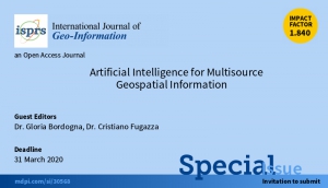

Gloria Bordogna and Cristiano Fugazza of IREA-CNR announce the call of the Special Issue "Artificial Intelligence for Multisource Geospatial Information" of the International Journal of GeoInformation (IJGI), an international open-access peer-reviewed journal published by MDPI.
The Special Issue is devoted to collecting original research contributions focused on the definition and application of Artificial Intelligence methods for acquisition, filtering, management, analysis, discovery, and visualization of geospatial information from multiple sources, i.e., geospatial big data. Key applications are Earth observation for territorial monitoring and change detections, including urban and land use dynamics and anomaly detection; social conditions and habits detection, characterization, monitoring and prediction regarding, for example, poverty locations, citizens mobility, work, and recreation; event detection and forecasting for emergency preparedness and management, and many more. This field, also named geospatial artificial intelligence (or geoAI), applies many techniques of the most general artificial intelligence (AI), such as machine learning, deep learning, semantic representation and analysis, knowledge discovery, data mining, and soft computing. However, the specificities and importance of the geospatial dimension, its heterogeneity, the need for representing distinct semantics of locations, as well as to analyze the role of their temporal changes by performing geospatial and temporal reasoning pose new challenges and opportunities that AI has to face.
The deadline for submitting the articles is March 31st, 2020.
For all information go to this link.
 Brno, Czech Republic March 30-April 3, 2020
For further information, download the Call for Papers below
 What produced the recent Mount Etna volcanic-tectonic crisis, culminating with the ML 4.8 earthquake occurred along the Fiandaca Fault on the southeastern flank of the volcano? The main cause could be the ascent of deep magma, which could have put under tension the flanks of the volcano, triggering relevant seismic swarms along the Ragalna Fault System (southwest flank), the Pernicana Fault System (northeast flank) and, more violently, along the Fiandaca Fault (southeast flank), where the seismic swarm also produced a widespread surficial faulting and damage. The same ascent of deep magma could also have triggered the brief eruption of Mount Etna on 24-27 December 2018; the entire intrusive and deformative process may not have been completely exhausted (Figure 1 on the left).
This hypothesis is formulated in a study conducted by a team of researchers from the Institute for Electromagnetic Sensing of the Environment of the National Research Council (IREA-CNR, Naples) and the National Institute of Geophysics and Volcanology (INGV, Catania and Rome), in collaboration with the Department of Civil Protection (DPC, Rome).
The results of this research are based on the analysis of the radar images of the Sentinel-1 satellites belonging to the constellation of the Copernicus European program, processed through the interferometric technique (InSAR), with which the Mount Etna ground deformations induced by the eruptive and seismic activity were measured with centimetre accuracy. "The availability of satellite radar data of the Sentinel-1 constellation, from the Copernicus European program, and of the COSMO-SkyMed constellation of the Italian Space Agency (ASI) and the Ministry of Defense", highlights Riccardo Lanari, director of IREA-CNR, "has allowed detecting in detail the ground movements that affected the Mount Etna volcanic edifice during the 24-27 December 2018 eruption. The identification of both magmatic and seismogenic sources, which caused the deformations detected by satellites, has been possible thanks to a multidisciplinary approach, which integrated the seismological and field data with the satellite radar data processed by IREA-CNR " (Figure 2).
Through a process called "data inversion" and with the help of mathematical models, the volcanic and seismic sources that generated the deformations were reconstructed, succeeding in demonstrating the causal link between eruption and earthquakes. "The analytical modeling", says Vincenzo De Novellis, IREA-CNR researcher "has allowed us to distinguish two different deformative sources connected with the magma intrusion: a very surficial one, which caused the opening of the observed cracks from which the lava has flown, and a deeper one (from 3 to 8.5 km) which exercised a tension on the volcano flanks, triggering the fault movement and, therefore, generating the numerous earthquakes recorded by the monitoring network of the INGV ” (Figure 3).
"That the strong subsidence of the area close to La Montagnola (about 3 km south of the Mount Etna summit crater area) was a secondary effect of the deep magmatic intrusion was only understood thanks to the analytical modeling" adds Simone Atzori, INGV researcher. "With the same technique," continues Atzori, "we have analyzed and quantified the interactions that occurred between the magma ascent and the surrounding faults, including the Fiandaca, Pernicana and Ragalna structures".
"Understanding the cause-effect relationships between magmatic intrusions and earthquakes has always been an extremely interesting scientific challenge, first of all for the implications that these studies have on the evaluation of seismic and volcanic hazard", concludes Marco Neri, senior researcher at INGV. "And it is not said that it is effectively concluded. By comparing the large ground deformations occurred in the last few months and the small eruption of December, we can suppose that the volcano still has energy to spend. These are important assessments, especially for a densely urbanized area such as the Mount Etna one, where almost a million people live in close contact with one of the most active volcanoes in the world”.
The results of this research, entitled "DInSAR analysis and analytical modeling of Mt. Etna displacements: the December 2018 volcano-tectonic crisis", have just been published on the American journal Geophysical Research Letters (https://doi.org/10.1029/2019GL082467) and are now available to the scientific community and Civil Protection, which has also contributed to the publication: these results will represent a reference point to improve risk estimation in an area with such a high population density.
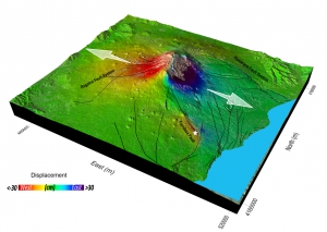
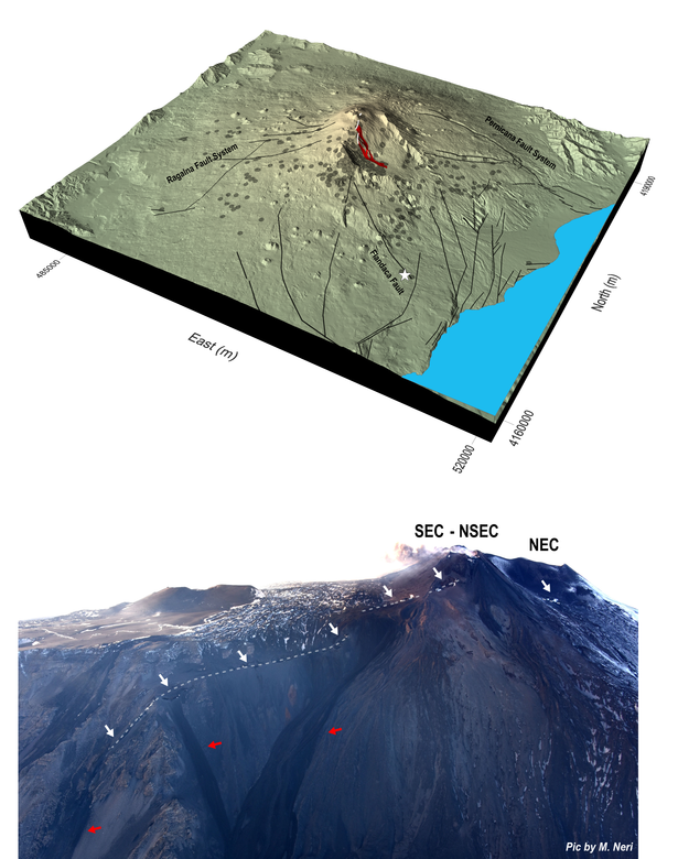
Figure 1. Above: Three-dimensional view of Mount Etna showing the eruptive fissures (white lines) from which the lava (in red) has flown on 24 December 2018, the main structural features of the volcano (black lines) and the 26 December earthquake (white star). The grey circles represent the epicentres of the earthquakes that nucleated from 24 to 27 December. Bottom: photograph acquired during a helicopter flight from west to east, in which it is possible to recognize the eruptive fissures (white dashed lines) and the main lava flow emerging from the cracks (red arrows). SEC: Southeast Crater; NSEC: New Southeast Crater; NEC: Northeast Crater.
|
Figure 2. Three-dimensional view of the horizontal component (in East-West direction) of the reconstructed ground displacements through the analysis of the radar images of the Sentinel-1 satellites belonging to the constellation of the Copernicus European program. The two white arrows indicate the direction of the displacements whose maximum values exceed 30 cm towards west and 50 cm towards east on the top of the volcano. In the area near the epicentre of the 26 December earthquake (white star), the maximum eastward ground displacement is 14 cm, while the corresponding westward shift is of 17 cm. |
|
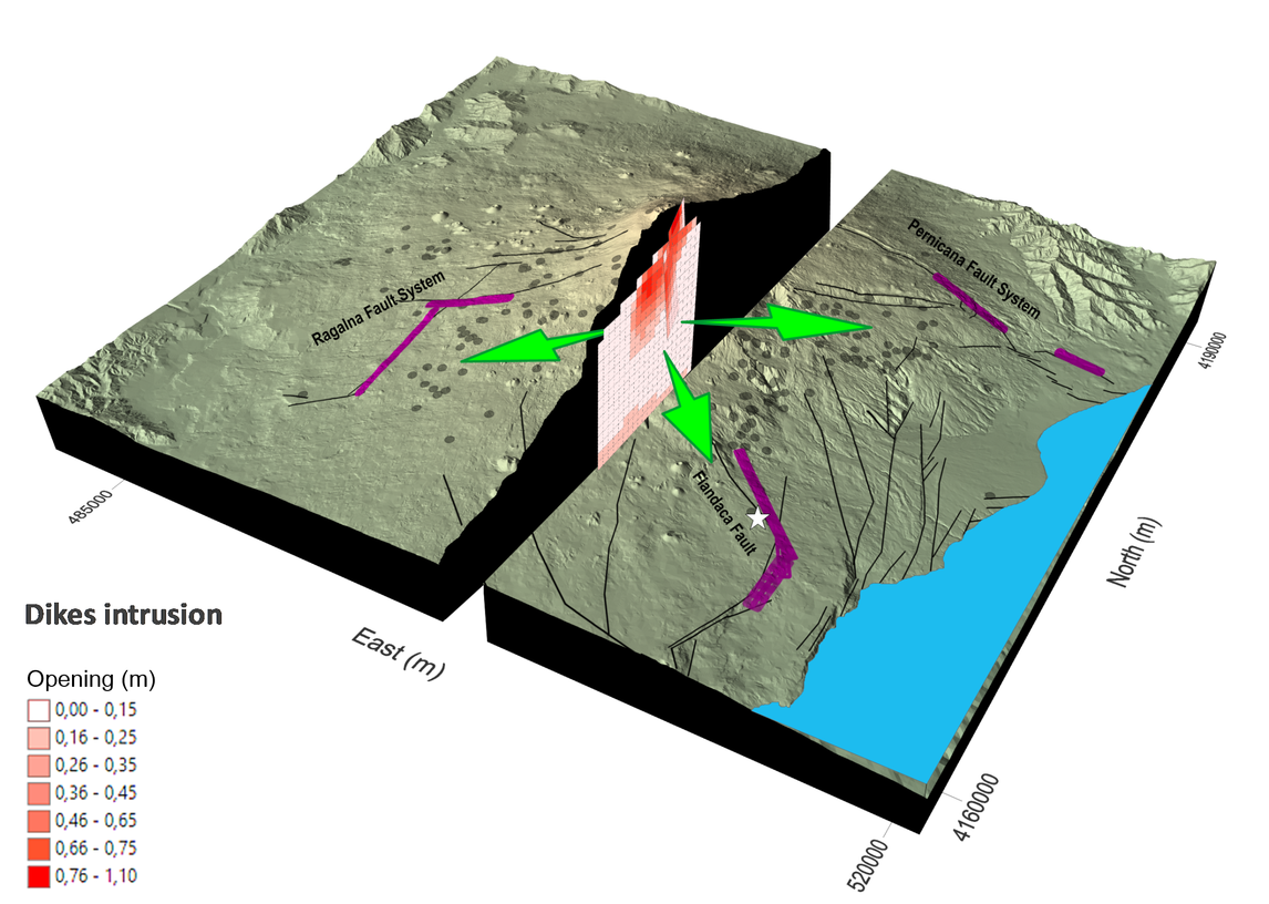
Figure 3. Three-dimensional view of Mount Etna, which summarizes the results of the model related to the volcano-tectonic events of December 2018. In the cutaway the two modelled magmatic bodies (dikes) were represented: a more surficial one, which caused the opening of the cracks from which the lava flow came out, and a deeper one, which exerted tension on the flanks of the volcano. The small squares that composed the modelled dikes indicate the greater presence (in red) or smaller (in light pink) of magma. The purple lines represent the fault planes calculated by the model, while the black ones represent the tectonic structures that actually emerge on the surface. Finally, the green arrows schematize the pressures exerted by magmatic intrusions, which should have "triggered" the movement of the faults, including the Fiandaca Fault along which the 26 December earthquake occurred (the epicenter is indicated with the white star). |

See the presentation of the results to this link


Maria Rosaria Scarfì, a senior researcher of IREA-CNR, was appointed co-director of the International School of Bioelectromagnetics "Alessandro Chiabrera", one of the Schools of the Ettore Majorana Foundation and Center for Scientific Culture (EMFCSC) in Erice (Sicily). From 2003, the year of its establishment, the director was Ferdinando Bersani, professor of Physics at the University of Bologna.
The School proposes every two years a course, organized by two co-directors with recognized experience on the specific topic and by the School co-directors, aimed at young researchers and biologists, engineers and physicists, on different aspects of the interaction between nonionizing radiations and biological systems.
The Ettore Majorana Foundation and Center for Scientific Culture (EMFCSC) is a scientific organization, founded in 1962 by the physicist Antonino Zichichi, who is also its president, and named after the Sicilian physicist Ettore Majorana. Since its establishment in 1962, more than 120,000 scientists - of which many Nobel prizes - from 140 countries have taken part in post-university activities to promote science without secrets and without borders.
Monitoring crustal deformation in active volcanic areas could not be an easy task. Space-borne remote sensing can make the difference with respect to in-situ techniques, due to its capability to provide dense measurements at large spatial scale and at relatively low cost. These results will be presented on April 9th during a scientific talk (Room M2 at 9:30) and a press conference (at 13:00) at the next European Geophysical Union (EGU) General Assembly that will be held from 7th to 12th April in Vienna.
Differential Synthetic Aperture Radar Interferometry (DInSAR) is becoming one of the usual techniques to measure ground deformation with high accuracy and in any atmospheric conditions. The increasing diffusion of the use of DInSAR is due to the recent availability of huge and easily accessible SAR data archives, as those provided, since late 2014, by the Copernicus Sentinel-1 constellation. Sentinel-1 is nowadays providing SAR data every 6 days (in the best case) all over the Earth. It is therefore clear that with such a huge, global, constant and reliable availability of data it is possible to use the DInSAR technique for monitoring purposes, such as those related to the measurements of the ground motion in volcanic areas.
Researchers at the Institute of Electromagnetic Sensing of Environment (IREA) of the Italian National Research Council (CNR) have developed an operative service for monitoring the crustal deformation in active volcanoes through the use of DInSAR technique and Sentinel-1 data. The designed system is fully automatic and the process is triggered by the availability, for every monitored volcano site, of a new acquired Sentinel-1 data. The satellite data are ingested and processed through the well-known Parallel Small BAseline Subset (P-SBAS) DInSAR technique (fully developed at IREA-CNR) in order to generate the displacement time series of the investigated area.
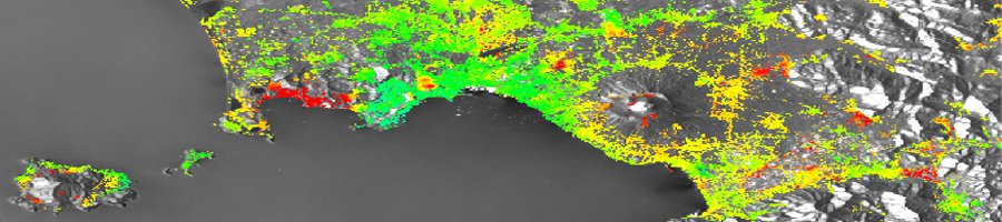
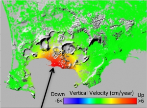
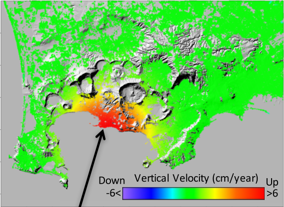
Being a Center of Competence (CoC) of the Italian Department of Civil Protection (DPC), CNR-IREA operates the described service to monitor the ground deformation of the main active Italian volcanoes, such as the Campi Flegrei caldera, Mt. Vesuvius, Ischia, Mt. Etna and Stromboli and provides monthly updates on the volcanoes’ deformation statuses to DPC and others CdC devoted to volcano monitoring. As an example, in the figure is reported the ground deformation affecting the Campi Flegrei caldera, near the city of Naples (Italy), which is experiencing an uplift of about 8.5 cm/year since July 2017.
Although the service is intended to serve the Italian DPC, it has been built to be easily portable and replicable for other volcanoes in the Earth, thus fully benefiting from the DInSAR monitoring capabilities of Sentinel-1.
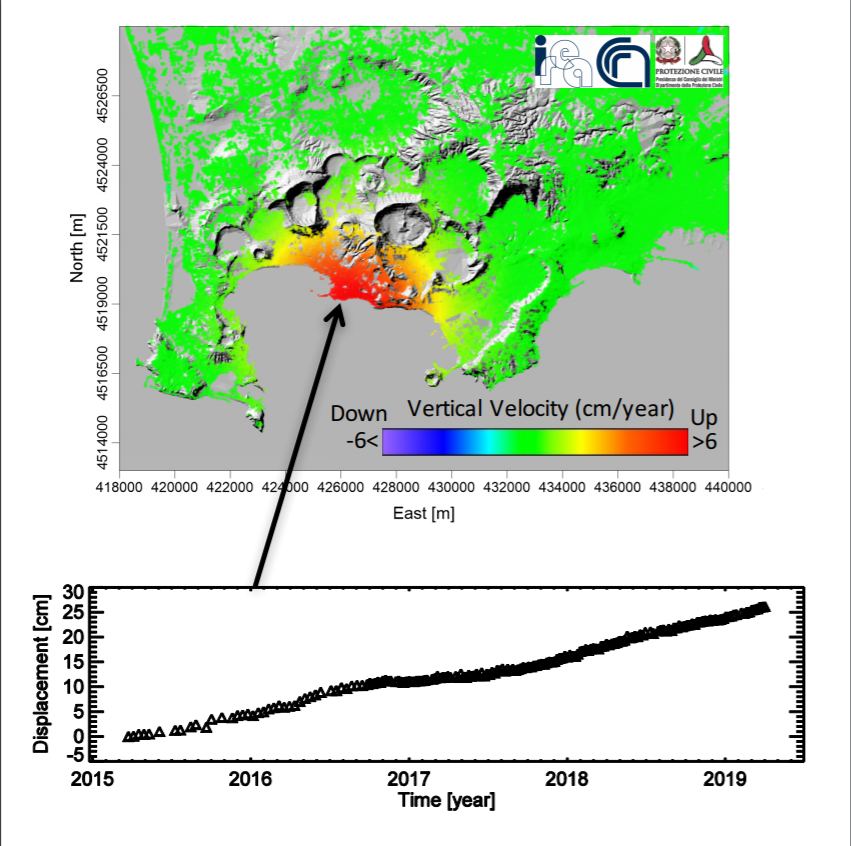
The graph shows the temporal evolution of the deformation that, since March 2015, uplifted of about 25 cm. Contains modified Copernicus data ©2019.
This work is supported by the IREA-CNR and Italian Civil Protection Department 2019-2021 agreement, the H2020 EPOS-IP project (GA 676564), the I-AMICA (PONa3_00363) project, and the IREA-CNR/DGS-UNMIG agreement.

![]() IREA, the Institute for Electromagnetic Sensing of the Environment of the National Research Council (CNR) of Italy, has selected ONDA, through a public invitation to tender open to the DIAS platforms, to provide cloud resources for processing Sentinel-1 data.
IREA, the Institute for Electromagnetic Sensing of the Environment of the National Research Council (CNR) of Italy, has selected ONDA, through a public invitation to tender open to the DIAS platforms, to provide cloud resources for processing Sentinel-1 data.
IREA has already been using the ONDA platform as an early adopter for the development of surface deformation products implementing interferometric SAR (InSAR) techniques.
“We are very pleased to continue our collaboration with ONDA,” said Riccardo Lanari, the IREA director. “We believe that the flexibility and reliability of the ONDA platform will be a benefit for us, especially as regards our developments on large scale InSAR data processing.
Indeed, these characteristics can be particularly relevant for our activities, carried out to support the Civil Protection Department of Italy and the Satellite Data Thematic Core Service of the European Plate Observing System (EPOS), which is the European Research Infrastructure Consortium (ERIC) focused on Solid Earth.”
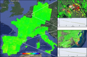
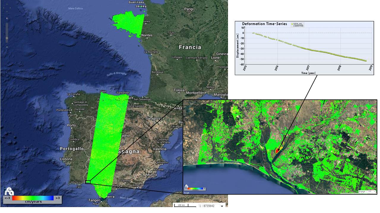
The figure above is an example of the products processed by IREA through the ONDA cloud resources, and shows the results related to the generated mean deformation velocity maps and the corresponding time series of 7 slices of the descending Sentinel-1 track no. 154.
Note that a large area of Spain is mapped through the first 6 slices, while the 7th one covers Normandy. To give an idea of the information content of the generated products, a zoom of a selected area (showing a localized deformation pattern) is also presented, as well as the retrieved deformation time series of one pixel.
The mapped area extends for almost 150000 km2 and for each slice a number of Sentinel-1 images ranging from 142 to 160 were processed.
Learn more:
• IREA Earth surface deformation project on ONDA Marketplace
• IREA (Institute for Electromagnetic Sensing of the Environment)
• CNR (National Research Council)
• Civil Protection Department (Italy)
• European Plate Observing System (EPOS)
• European Research Infrastructure Consortium (ERIC)